 |
|
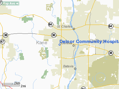
Delnor Community Hospital Heliport |
Location
& QuickFacts
|
FAA
Information Effective: |
2007-07-05 |
|
Airport
Identifier: |
76IL |
|
Airport
Status: |
Operational |
|
Longitude/Latitude: |
088-20-37.0000W/41-53-15.0000N
-88.343611/41.887500 (Estimated) |
|
Elevation: |
770 ft / 234.70 m (Estimated) |
|
Land: |
0 acres |
|
From
nearest city: |
2 nautical miles W of Geneva, IL |
|
Location: |
Kane County, IL |
|
Magnetic Variation: |
01W (1995) |
Owner & Manager
|
Ownership: |
Privately owned |
|
Owner: |
Delnor Community Hospital |
|
Address: |
300 Randall Road
Geneva, IL 60134 |
|
Phone number: |
630-208-3000 |
|
Manager: |
Jerry Wolf |
|
Address: |
300 Randall Road
Geneva, IL 60134 |
|
Phone number: |
630-208-4271 |
Airport
Operations and Facilities
|
Airport
Use: |
Private
MEDICAL USE. |
|
Wind
indicator: |
Yes |
|
Segmented Circle: |
No |
|
Control
Tower: |
No |
|
Lighting
Schedule: |
PHONE REQ
FOR FLOOD LGTS CALL 630-208-4271. |
|
Sectional chart: |
Chicago |
|
Region: |
AGL - Great Lakes |
|
Boundary
ARTCC: |
ZAU - Chicago |
|
Tie-in
FSS: |
IKK - Kankakee |
|
FSS
on Airport: |
No |
|
FSS
Toll Free: |
1-800-WX-BRIEF |
|
Runway Information
Helipad H1
|
Dimension: |
50
x 50 ft / 15.2 x 15.2 m |
|
Surface: |
CONC, Good Condition |
|
|
Runway H1 |
Runway |
|
Traffic
Pattern: |
Left |
Left |
|
Radio Navigation
Aids
|
ID |
Type |
Name |
Ch |
Freq |
Var |
Dist |
|
ME |
NDB |
Deana |
|
350.00 |
00E |
15.0 nm |
|
DKB |
NDB |
Dekalb |
|
209.00 |
02W |
16.5 nm |
|
HK |
NDB |
Ermin |
|
332.00 |
01W |
24.9 nm |
|
MX |
NDB |
Kedzi |
|
248.00 |
01W |
30.6 nm |
|
OIX |
NDB |
Ottawa |
|
266.00 |
01E |
39.0 nm |
|
VYS |
NDB |
Valley |
|
230.00 |
00W |
48.3 nm |
|
DPA |
VOR/DME |
Dupage |
021X |
108.40 |
02E |
0.3 nm |
|
ORD |
VOR/DME |
Chicago O'hare |
086X |
113.90 |
02E |
20.5 nm |
|
OBK |
VOR/DME |
Northbrook |
077X |
113.00 |
02W |
26.6 nm |
|
RFD |
VOR/DME |
Rockford |
045X |
110.80 |
01E |
43.3 nm |
|
ENW |
VOR/DME |
Kenosha |
029X |
109.20 |
02W |
46.5 nm |
|
BUU |
VOR/DME |
Burbun |
092X |
114.50 |
01W |
48.2 nm |
|
JOT |
VORTAC |
Joliet |
070X |
112.30 |
02E |
20.5 nm |
|
CGT |
VORTAC |
Chicago Heights |
089X |
114.20 |
02E |
41.4 nm |
|
EON |
VORTAC |
Peotone |
079X |
113.20 |
02E |
44.7 nm |
|
ORD |
VOT |
Chicago O'hare Intl |
|
112.00 |
|
20.3 nm |
|
MDW |
VOT |
Chicago Midway |
|
111.00 |
|
27.2 nm |
Remarks
- REFER
TO AIRSPACE LTR DATED 1/9/91.
Delnor Community Hospital Heliport
Address:
Kane County, IL
Tel:
630-208-3000, 630-208-4271
Images
and information placed above are from
http://www.airport-data.com/airport/76IL/
We
thank them for the data!
| General
Info |
| Country |
United
States |
| State |
ILLINOIS
|
| FAA ID |
76IL |
| Latitude |
41-53-15.000N
|
| Longitude |
088-20-37.000W
|
| Elevation |
770 feet
|
| Near City |
GENEVA
|
We don't guarantee the information is fresh and accurate. The data may
be wrong or outdated.
For more up-to-date information please refer to other sources.
|
|


