 |
|
| Decatur Airport |
 |
| FAA airport diagram (August 2009) |
| IATA: DEC â ICAO: KDEC â FAA LID: DEC |
| Summary |
| Airport type |
Public |
| Owner |
Decatur Park District |
| Serves |
Decatur, Illinois |
| Elevation AMSL |
682 ft / 208 m |
| Coordinates |
39°50â²04â³N 088°51â²56â³W / 39.83444°N 88.86556°W / 39.83444; -88.86556 |
| Website |
decatur-airport.org |
| Runways |
| Direction |
Length |
Surface |
| ft |
m |
| 6/24 |
8,496 |
2,590 |
Asphalt/Concrete |
| 12/30 |
6,799 |
2,072 |
Asphalt/Concrete |
| 18/36 |
5,299 |
1,615 |
Asphalt |
| Statistics (2008) |
| Aircraft operations |
44,614 |
| Based aircraft |
90 |
| Source: Federal Aviation Administration |
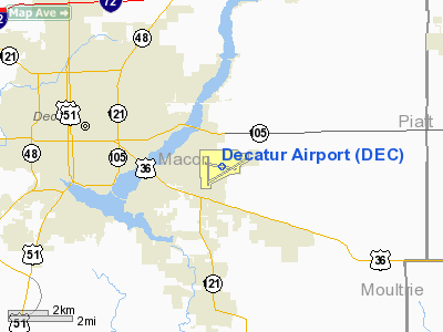
Decatur Airport (IATA: DEC, ICAO: KDEC, FAA LID: DEC) is a public use airport located four nautical miles (7 km) east of the central business district of Decatur, a city in Macon County, Illinois, United States. It is owned by the Decatur Park District.
The airport is used for general aviation, but mostly for one commercial airline. Service is subsidized by the Essential Air Service program. Facilities and aircraft
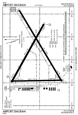
Decatur Airport covers an area of 2,100 acres (850 ha) at an elevation of 682 feet (208 m) above mean sea level. It has three paved runways: 6/24 is 8,496 by 150 feet (2,590 x 46 m); 12/30 is 6,799 by 150 feet (2,072 x 46 m); 18/36 is 5,299 by 150 feet (1,615 x 46 m).
For the 12-month period ending December 31, 2008, the airport had 44,614 aircraft operations, an average of 122 per day: 77.5% general aviation, 16.7% military. 5.7% air taxi, and 0.1% scheduled commercial, At that time there were 90 aircraft based at this airport: 64.4% single-engine, 7.8% multi-engine, 5.6% jet, 6.7% helicopter and 15.6% military.
Decatur Airport maintains a 24,000 square feet (2,200 m) passenger terminal building that contains airline counters, a restaurant, the baggage claim area and a car rental facility.
The Illinois Army National Guard operates an Army Aviation Support Facility (AASF) at the airport. The facility occupies 10 acres (4.0 ha) and has 3 permanent buildings and 1 temporary building on the site.
Airlines and destinations
| Airlines |
Destinations |
| Air Choice One |
Chicago-O'Hare, St. Louis |
Accidents and incidents
- On August 3, 1950 a United States Air Force Douglas C-47D was destroyed by fire after a take-off related accident. All 5 occupants survived the crash and subsequent fire.
- On October 2, 2006 a United States Air Force Learjet C-21A was on a training mission flying a simulated approach to runway 24 when the planes speed unexpectedly dropped and called out "speed" two times. The pilot pulled back the number one engine throttle but the plane began to roll steeply to the right and struck the pavement before proceeding to skid through a grass infield and then across another runway before coming to a stop. Both occupants survived but were also determined to be at fault for the crash.
The above content comes from Wikipedia and is published under free licenses – click here to read more.
Location
& QuickFacts
|
FAA
Information Effective: |
2007-07-05 |
|
Airport
Identifier: |
DEC |
|
Airport
Status: |
Operational |
|
Longitude/Latitude: |
088-51-56.4810W/39-50-04.4250N
-88.865689/39.834562 (Estimated) |
|
Elevation: |
682 ft / 207.87 m (Surveyed) |
|
Land: |
2100 acres |
|
From
nearest city: |
4 nautical miles E of Decatur, IL |
|
Location: |
Macon County, IL |
|
Magnetic Variation: |
01W (2000) |
Owner & Manager
|
Ownership: |
Publicly owned |
|
Owner: |
Decatur Park District |
|
Address: |
Box 1136
Decatur, IL 62525 |
|
Phone number: |
217-428-2423 |
|
Manager: |
Gene Marcinkowski |
|
Address: |
910 Airport Road
Decatur, IL 62521 |
|
Phone number: |
217-428-2423 |
Airport
Operations and Facilities
|
Airport
Use: |
Open
to public |
|
Wind
indicator: |
Yes |
|
Segmented Circle: |
No |
|
Control
Tower: |
Yes |
|
Lighting
Schedule: |
DUSK-DAWN
WHEN ATCT CLSD HIRL RY 06/24 PRESET LOW INTST; TO INCR INTST
& ACTVT MIRL RYS 12/30 & 18/36; PAPI RY 30, TWY
LGTS & MALSR RY 06 - CTAF. |
|
Beacon
Color: |
Clear-Green (lighted land airport) |
|
Landing
fee charge: |
No |
|
Sectional chart: |
St Louis |
|
Region: |
AGL - Great Lakes |
|
Boundary
ARTCC: |
ZKC - Kansas City |
|
Responsible ARTCC: |
ZAU - Chicago |
|
Tie-in
FSS: |
STL - Saint Louis |
|
FSS
Phone: |
636-536-2980 |
|
FSS
Toll Free: |
1-800-WX-BRIEF |
|
NOTAMs
Facility: |
DEC (NOTAM-d service avaliable) |
|
Certification type/date: |
II A S 05/197
24 HRS PPR FOR UNSKED ACR OPNS WITH MORE THAN 30 PSGR SEATS
CALL AMGR 217-428-2423 OR 217-428-8836. PPR FOR ARFF INDEX
B CALL AMGR. |
|
Federal Agreements: |
NGY3 |
Airport Communications
|
CTAF: |
118.900 |
|
Unicom: |
122.950 |
Airport Services
|
Runway Information
Runway 06/24
|
Dimension: |
8496
x 150 ft / 2589.6 x 45.7 m |
|
Surface: |
ASPH-CONC, Good Condition |
|
Surface
Treatment: |
Saw-cut or plastic Grooved |
|
Weight
Limit: |
Single wheel: 75000 lbs.
Dual wheel: 200000 lbs.
Dual tandem wheel: 245000 lbs. |
|
Edge
Lights: |
High |
|
|
Runway 06 |
Runway 24 |
|
Longitude: |
088-52-28.2620W |
088-50-54.7850W |
|
Latitude: |
39-49-37.5510N |
39-50-20.6310N |
|
Elevation: |
672.00 ft |
682.00 ft |
|
Alignment: |
59 |
127 |
|
ILS
Type: |
ILS/DME |
|
|
Traffic
Pattern: |
Left |
Left |
|
Markings: |
Precision instrument, Fair Condition |
Precision instrument, Fair Condition |
|
Crossing
Height: |
0.00 ft |
41.00 ft |
|
VASI: |
|
4-box on left side |
|
Visual
Glide Angle: |
0.00° |
3.00° |
|
RVR
Equipment: |
touchdown |
|
|
Approach
lights: |
MALSR |
|
|
Runway
End Identifier: |
No |
No |
|
Centerline
Lights: |
No |
No |
|
Touchdown
Lights: |
No |
No |
|
Obstruction: |
17 ft road, 885.0 ft from runway, 599 ft left
of centerline, 39:1 slope to clear |
, 50:1 slope to clear |
|
Runway 12/30
|
Dimension: |
6799
x 150 ft / 2072.3 x 45.7 m |
|
Surface: |
ASPH-CONC, Good Condition |
|
Surface
Treatment: |
Saw-cut or plastic Grooved |
|
Weight
Limit: |
Single wheel: 75000 lbs.
Dual wheel: 200000 lbs.
Dual tandem wheel: 245000 lbs. |
|
Edge
Lights: |
Medium |
|
|
Runway 12 |
Runway 30 |
|
Longitude: |
088-52-29.2780W |
088-51-13.1570W |
|
Latitude: |
39-50-28.5200N |
39-49-55.7960N |
|
Elevation: |
678.00 ft |
678.00 ft |
|
Alignment: |
119 |
127 |
|
Traffic
Pattern: |
Left |
Left |
|
Markings: |
Non-precision instrument, Fair Condition |
Nonstandard, Fair Condition |
|
VASI: |
|
4-light PAPI on left side |
|
Runway
End Identifier: |
No |
|
|
Centerline
Lights: |
No |
No |
|
Touchdown
Lights: |
No |
No |
|
Obstruction: |
43 ft tree, 1174.0 ft from runway, 288 ft right
of centerline, 22:1 slope to clear |
, 50:1 slope to clear |
|
Runway 18/36
|
Dimension: |
5299
x 150 ft / 1615.1 x 45.7 m |
|
Surface: |
ASPH, Good Condition |
|
Surface
Treatment: |
Saw-cut or plastic Grooved |
|
Weight
Limit: |
Single wheel: 75000 lbs.
Dual wheel: 115000 lbs.
Dual tandem wheel: 180000 lbs. |
|
Edge
Lights: |
Medium |
|
|
Runway 18 |
Runway 36 |
|
Longitude: |
088-52-27.7390W |
088-52-26.6920W |
|
Latitude: |
39-50-29.2360N |
39-49-36.8750N |
|
Elevation: |
678.00 ft |
672.00 ft |
|
Alignment: |
127 |
127 |
|
Traffic
Pattern: |
Left |
Left |
|
Markings: |
Non-precision instrument, Fair Condition |
Short takeoff and landing, Good Condition |
|
Crossing
Height: |
41.00 ft |
42.00 ft |
|
VASI: |
4-light PAPI on left side |
4-box on left side |
|
Visual
Glide Angle: |
3.00° |
3.00° |
|
Runway
End Identifier: |
|
Yes |
|
Centerline
Lights: |
No |
No |
|
Touchdown
Lights: |
No |
No |
|
Obstruction: |
, 50:1 slope to clear |
50 ft pole, 2344.0 ft from runway, 461 ft left
of centerline, 42:1 slope to clear |
|
Radio Navigation
Aids
|
ID |
Type |
Name |
Ch |
Freq |
Var |
Dist |
|
SYZ |
NDB |
Shelbyville |
|
365.00 |
01E |
25.7 nm |
|
TAZ |
NDB |
Taylorville |
|
395.00 |
00E |
27.8 nm |
|
AAA |
NDB |
Abraham |
|
329.00 |
00E |
29.2 nm |
|
LQ |
NDB |
Licol |
|
375.00 |
01W |
34.3 nm |
|
MT |
NDB |
Zebre |
|
347.00 |
00E |
39.8 nm |
|
SP |
NDB |
Huskk |
|
382.00 |
01W |
41.5 nm |
|
HMJ |
NDB |
Homer |
|
281.00 |
01E |
43.6 nm |
|
MTO |
VOR/DME |
Mattoon |
031X |
109.40 |
03E |
34.3 nm |
|
BMI |
VOR/DME |
Bloomington |
019X |
108.20 |
03E |
39.0 nm |
|
DEC |
VORTAC |
Decatur |
119X |
117.20 |
03E |
5.8 nm |
|
CMI |
VORTAC |
Champaign |
037X |
110.00 |
03E |
29.7 nm |
|
CAP |
VORTAC |
Capital |
074X |
112.70 |
04E |
35.2 nm |
|
SPI |
VORTAC |
Spinner |
74X |
112.70 |
01W |
37.5 nm |
|
VLA |
VORTAC |
Vandalia |
090X |
114.30 |
04E |
46.6 nm |
Remarks
- NORTH
RAMP FROM HANGAR B TO HANGAR G CLOSED TO AIRCRAFT OVER 12500 LBS.
- WHEN
ATCT CLSD BE ALERT FOR INTMT VEHICULAR TFC IN ARPT OPNS AREAS.
- BIRDS;
DEER & OTHER WILDLIFE ON & INVOF ARPT.
- GLIDER
OPNS BY WRITTEN APVL ONLY; CONTACT AMGR 217-428-2423. GLIDER OPNS ALLOWED
ON RYS 06 & 30 ONLY. NO
SOD OPNS.
- SNOW
REMOVAL OPNS IN PROGRESS WINTER MONTHS; VEHICLE OPERATORS WILL BE MONITORING
CTAF; ACFT LNDG/DEP USE CTAF WHEN ATCT CLSD.
- FOR
US CUSTOMS CALL 217-425-4803.
- RY
12 & RY 18 APCH ENDS ARE CLOSELY ALIGNED. RY 06 & RY 36 APCH
ENDS ARE CLOSELY AIGNED. VERIFY
CORRECT RY AND COMPASS HEADING PRIOR TO DEP.
Based
Aircraft
|
Aircraft
based on field: |
98 |
|
Single
Engine Airplanes: |
54 |
|
Multi
Engine Airplanes: |
11 |
|
Jet
Engine Airplanes: |
5 |
|
Helicopters: |
14 |
|
Military: |
14 |
Operational Statistics
Time Period: 2005-01-01
- 2005-12-31
|
Aircraft
Operations: |
114/Day |
|
Commerical: |
6.3% |
|
General
Aviation Local: |
39.9% |
|
General
Aviation Itinerant: |
45.3% |
|
Military: |
8.4% |
Decatur Airport
Address:
Macon County, IL
Tel:
217-428-2423
Images
and information placed above are from
http://www.airport-data.com/airport/DEC/
We
thank them for the data!
| General
Info |
| Country |
United
States |
| State |
ILLINOIS
|
| FAA ID |
DEC |
| Latitude |
39-50-04.425N
|
| Longitude |
088-51-56.481W
|
| Elevation |
682 feet
|
| Near City |
DECATUR
|
We don't guarantee the information is fresh and accurate. The data may
be wrong or outdated.
For more up-to-date information please refer to other sources.
|
|


