 |
|
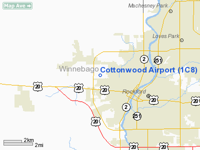
Cottonwood Winnebago Airport |
|
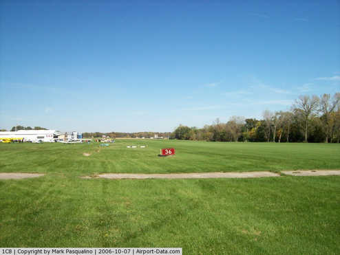 |
(Click on the photo to enlarge) |
|
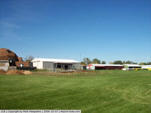 |
(Click on the photo to enlarge) |
Location
& QuickFacts
|
FAA
Information Effective: |
2007-07-05 |
|
Airport
Identifier: |
1C8 |
|
Airport
Status: |
Operational |
|
Longitude/Latitude: |
089-08-10.3860W/42-17-30.0690N
-89.136218/42.291686 (Estimated) |
|
Elevation: |
741 ft / 225.86 m (Surveyed) |
|
Land: |
38 acres |
|
From
nearest city: |
2 nautical miles NW of Rockford, IL |
|
Location: |
Winnebago County, IL |
|
Magnetic Variation: |
00E (1985) |
Owner
& Manager
|
Ownership: |
Privately
owned |
|
Owner: |
Cottonwood Corp |
|
Address: |
5105 Auburn St
Rockford, IL 61101 |
|
Phone
number: |
815-965-3050 |
|
Manager: |
Tom Janusevic |
|
Address: |
231 S. Highland Ave.
Rockford, IL 61104 |
|
Phone number: |
815-397-4995 |
Airport Operations and Facilities
|
Airport
Use: |
Open
to public |
|
Wind
indicator: |
Yes |
|
Segmented Circle: |
Yes |
|
Control
Tower: |
No |
|
Lighting
Schedule: |
DUSK-DAWN |
|
Landing
fee charge: |
No |
|
Sectional chart: |
Chicago |
|
Region: |
AGL - Great Lakes |
|
Traffic
Pattern Alt: |
800 ft |
|
Boundary
ARTCC: |
ZAU - Chicago |
|
Tie-in
FSS: |
IKK - Kankakee |
|
FSS
on Airport: |
No |
|
FSS
Toll Free: |
1-800-WX-BRIEF |
|
NOTAMs
Facility: |
IKK (NOTAM-d service avaliable) |
Airport
Communications
|
CTAF: |
122.800 |
|
Unicom: |
122.800
|
|
Runway Information
Runway 18/36
|
Dimension: |
2540
x 260 ft / 774.2 x 79.2 m |
|
Surface: |
TURF, Good Condition |
|
Edge
Lights: |
Non-standard lighting system
NSTD LIRL S 2250 FT LGTD; VARIABLE INTST AND NON-FRANGIBLE MOUNTS. |
|
|
Runway 18 |
Runway 36 |
|
Longitude: |
089-08-09.8800W |
089-08-09.8800W |
|
Latitude: |
42-17-43.6500N |
42-17-18.5700N |
|
Elevation: |
740.00 ft |
740.00 ft |
|
Traffic
Pattern: |
Right |
Left |
|
Markings: |
None, |
None, |
|
Displaced
threshold: |
0.00 ft |
400.00 ft
DSPLCD THLD MARKED WITH WHITE BARRELS & LGTS. |
|
Runway
End Identifier: |
No |
No |
|
Centerline
Lights: |
No |
No |
|
Touchdown
Lights: |
No |
No |
|
Obstruction: |
, 50:1 slope to clear |
60 ft tree, 265.0 ft from runway, 130 ft left
of centerline, 4:1 slope to clear
RWY 36 APCH RATIO 11:1 TO DSPLCD THR. |
|
Radio Navigation
Aids
|
ID |
Type |
Name |
Ch |
Freq |
Var |
Dist |
|
JVL |
NDB |
Janesville |
|
375.00 |
03E |
19.9 nm |
|
FEP |
NDB |
Freeport |
|
335.00 |
00E |
20.2 nm |
|
DKB |
NDB |
Dekalb |
|
209.00 |
02W |
28.8 nm |
|
LVV |
NDB |
Lake Lawn |
|
404.00 |
00W |
34.3 nm |
|
BOZ |
NDB |
Whiteside |
|
254.00 |
01E |
45.4 nm |
|
MS |
NDB |
Monah |
|
400.00 |
00E |
47.3 nm |
|
RFD |
VOR/DME |
Rockford |
045X |
110.80 |
01E |
4.9 nm |
|
JVL |
VOR/DME |
Janesville |
090X |
114.30 |
03E |
16.1 nm |
|
PLL |
VOR/DME |
Polo |
049X |
111.20 |
03E |
26.1 nm |
|
DPA |
VOR/DME |
Dupage |
021X |
108.40 |
02E |
42.6 nm |
|
BUU |
VOR/DME |
Burbun |
092X |
114.50 |
01W |
44.0 nm |
Remarks
- RY
36: +70' LGTD STADIUM POLES L & R 1300' FM RY END.
- EXISTED
PRIOR TO 1959.
Based
Aircraft
|
Aircraft
based on field: |
43 |
|
Single
Engine Airplanes: |
35 |
|
Helicopters: |
2 |
|
Ultralights: |
6 |
Operational Statistics
Time Period: 2004-01-02
- 2004-12-31
|
Aircraft
Operations: |
174/Week |
|
General
Aviation Local: |
66.7% |
|
General
Aviation Itinerant: |
33.3% |
Cottonwood Winnebago Airport
Address:
Winnebago County, IL
Tel:
815-965-3050,
815-397-4995
Images
and information placed above are from
http://www.airport-data.com/airport/1C8/
We
thank them for the data!
| General
Info |
| Country |
United
States |
| State |
ILLINOIS
|
| FAA ID |
1C8 |
| Latitude |
42-17-30.069N
|
| Longitude |
089-08-10.386W
|
| Elevation |
741 feet
|
| Near City |
ROCKFORD
|
We don't guarantee the information is fresh and accurate. The data may
be wrong or outdated.
For more up-to-date information please refer to other sources.
|
|


