 |
|
Central Il Regional Airport At Bloomington-Normal Airport |
| Central Illinois Regional Airport at Bloomington-Normal |
| IATA: BMI â ICAO: KBMI â FAA LID: BMI |
| Summary |
| Airport type |
Public |
| Owner |
Bloomington-Normal Airport Authority |
| Serves |
Bloomington / Normal, Illinois |
| Elevation AMSL |
871 ft / 265 m |
| Coordinates |
40°28â²38â³N 088°54â²57â³W / 40.47722°N 88.91583°W / 40.47722; -88.91583 |
| Runways |
| Direction |
Length |
Surface |
| ft |
m |
| 2/20 |
8,000 |
2,438 |
Concrete |
| 11/29 |
6,525 |
1,989 |
Asphalt/Concrete |
| Statistics (2007) |
| Aircraft operations |
41,980 |
| Based aircraft |
105 |
| Source: Federal Aviation Administration |
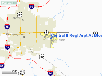
Central Illinois Regional Airport at Bloomington-Normal (IATA: BMI, ICAO: KBMI, FAA LID: BMI) is a public use airport located three nautical miles (6 km) east of the central business district of the city of Bloomington and southeast of the town of Normal, in McLean County, Illinois, United States. It is owned by the Bloomington-Normal Airport Authority. It is also known as Central Illinois Regional Airport and informally known as CIRA. Facilities and aircraft
Central Illinois Regional Airport covers an area of 1,968 acres (796 ha) at an elevation of 871 feet (265 m) above mean sea level. It has two runways: 2/20 with a 8,000 x 150 ft (2,438 x 46 m) concrete surface and 11/29 with a 6,525 x 150 ft. (1,989 x 46 m) asphalt/concrete surface.
For the 12-month period ending September 7, 2007, the airport had 41,980 aircraft operations, an average of 115 per day: 70% general aviation, 23% air taxi, 6% scheduled commercial and <1% military. At that time there were 105 aircraft based at this airport: 78% single-engine, 10% multi-engine and 12% jet.
On November 5, 2001, the airport opened a new $14 million terminal building, which was three times larger than the previous terminal. The new terminal currently has four ground level boarding gates (Gates 1-4) and five second level gates (Gates 5-9). Gates 4, 5, and 8 are equipped with jetways. Gates 6, 7, and 9 are jetway capable, but are not currently equipped. The terminal hosts two baggage carousels on the ground level. In addition, a business center open to the general public, conference rooms and a VIP lounge cater to busy business travelers. Wireless Internet access is available at no charge throughout the building.
Apart from the terminal, CIRA also has a healthy general aviation presence. The Fixed Based Operator on the field, Image Air, offers standard FBO services and amenities, as well as private and advanced flight training.
Hangar rental, fueling, and aircraft maintenance facilities are also available for private plane owners.
Airlines and destinations
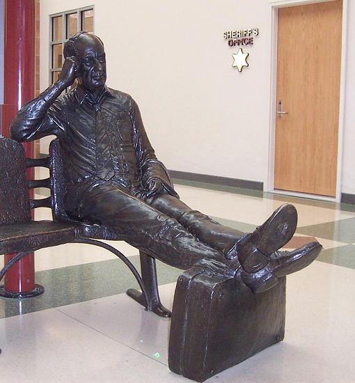 | |
CIRA terminal scene, with statue of statesman Adlai Stevenson |
| Airlines |
Destinations |
| AirTran Airways |
Atlanta, Fort Myers [Begins March 8], Orlando |
| American Connection operated by Chautauqua Airlines |
Chicago O'Hare |
| American Eagle |
Dallas/Ft. Worth |
| Delta Connection operated by Atlantic Southeast Airlines |
Atlanta |
| Delta Connection operated by Freedom Airlines |
Detroit |
| Delta Connection operated by Mesaba Airlines |
Minneapolis/St. Paul |
| Delta Connection operated by Pinnacle Airlines |
Detroit, Minneapolis/St. Paul |
The above content comes from Wikipedia and is published under free licenses – click here to read more.
Location
& QuickFacts
|
FAA
Information Effective: |
2007-07-05 |
|
Airport
Identifier: |
BMI |
|
Airport
Status: |
Operational |
|
Longitude/Latitude: |
088-54-57.3000W/40-28-37.6000N
-88.915917/40.477111 (Estimated) |
|
Elevation: |
871 ft / 265.48 m (Surveyed) |
|
Land: |
1968 acres |
|
From
nearest city: |
3 nautical miles E of Bloomington/normal,
IL |
|
Location: |
Mc Lean County, IL |
|
Magnetic Variation: |
00E (1985) |
Owner & Manager
|
Ownership: |
Publicly owned |
|
Owner: |
Bloomington Normal Arpt Auth |
|
Address: |
3201 Cira Drive
Bloomington, IL 61704 |
|
Phone number: |
309-663-7383 |
|
Manager: |
Carl G. Olson |
|
Address: |
3201 Cira Drive
Bloomington, IL 61704 |
|
Phone number: |
309-663-7383 |
Airport
Operations and Facilities
|
Airport
Use: |
Open
to public |
|
Wind
indicator: |
Yes |
|
Segmented Circle: |
No |
|
Control
Tower: |
Yes |
|
Lighting
Schedule: |
DUSK-DAWN
WHEN ATCT CLSD HIRL RY 11/29 PRESET ON LOW INTST; TO INCR
INTST & ACTVT HIRL RY 02/20, MALSR RYS 02 & 29 &
PAPI RY 02 - CTAF.
ALSF ON WHEN TWR OPEN. |
|
Beacon
Color: |
Clear-Green (lighted land airport) |
|
Landing
fee charge: |
No |
|
Sectional chart: |
Chicago |
|
Region: |
AGL - Great Lakes |
|
Boundary
ARTCC: |
ZAU - Chicago |
|
Tie-in
FSS: |
IKK - Kankakee |
|
FSS
on Airport: |
No |
|
FSS
Toll Free: |
1-800-WX-BRIEF |
|
NOTAMs
Facility: |
BMI (NOTAM-d service avaliable) |
|
Certification type/date: |
I B S 05/1973
48 HR PPR FOR UNSKED ACR OPNS WITH MORE THAN 30 PSGR SEATS;
CALL AMGR 309-663-7383. |
|
Federal Agreements: |
NGY |
Airport Communications
|
CTAF: |
124.600 |
|
Unicom: |
122.950
|
Airport
Services
|
Fuel
available: |
100LLA |
|
Airframe
Repair: |
MAJOR |
|
Power
Plant Repair: |
MAJOR |
|
Bottled
Oxygen: |
LOW |
|
Bulk
Oxygen: |
NONE |
|
Runway Information
Runway 02/20
|
Dimension: |
8000
x 150 ft / 2438.4 x 45.7 m |
|
Surface: |
CONC, Good Condition
SE END OF RY 29 750 FT CONC, REMAINING 5750 FT ASPH. |
|
Surface
Treatment: |
Saw-cut or plastic Grooved |
|
Weight
Limit: |
Single wheel: 75000 lbs.
Dual wheel: 150000 lbs.
Dual tandem wheel: 300000 lbs. |
|
Edge
Lights: |
High |
|
|
Runway 02 |
Runway 20 |
|
Longitude: |
088-54-57.6900W |
088-54-25.8600W |
|
Latitude: |
40-27-50.5900N |
40-29-05.8100N |
|
Elevation: |
857.00 ft |
863.00 ft |
|
Alignment: |
18 |
127 |
|
ILS
Type: |
ILS/DME |
ILS/DME |
|
Traffic
Pattern: |
Left |
Left |
|
Markings: |
Precision instrument, Fair Condition |
Precision instrument, Fair Condition |
|
Crossing
Height: |
50.00 ft |
0.00 ft |
|
VASI: |
4-light PAPI on right side |
|
|
Visual
Glide Angle: |
3.00° |
0.00° |
|
Approach
lights: |
MALSR |
ALSF2 |
|
Centerline
Lights: |
Yes |
Yes |
|
Touchdown
Lights: |
|
Yes |
|
Obstruction: |
, 50:1 slope to clear |
40 ft pline, 2007.0 ft from runway, 770 ft
left of centerline, 45:1 slope to clear |
|
Runway 11/29
|
Dimension: |
6525
x 150 ft / 1988.8 x 45.7 m |
|
Surface: |
ASPH-CONC, Good Condition
SE END OF RY 29 750 FT CONC, REMAINING 5750 FT ASPH. |
|
Surface
Treatment: |
Saw-cut or plastic Grooved |
|
Weight
Limit: |
Single wheel: 75000 lbs.
Dual wheel: 105000 lbs.
Dual tandem wheel: 300000 lbs. |
|
Edge
Lights: |
High |
|
|
Runway 11 |
Runway 29 |
|
Longitude: |
088-55-56.4300W |
088-54-36.0800W |
|
Latitude: |
40-28-59.0700N |
40-28-39.2600N |
|
Elevation: |
872.00 ft |
871.00 ft |
|
Alignment: |
107 |
127 |
|
ILS
Type: |
|
ILS |
|
Traffic
Pattern: |
Left |
Left |
|
Markings: |
Precision instrument, Good Condition |
Precision instrument, Good Condition |
|
Crossing
Height: |
43.00 ft |
0.00 ft |
|
VASI: |
4-box on right side |
|
|
Visual
Glide Angle: |
3.00° |
0.00° |
|
Approach
lights: |
|
MALSR |
|
Runway
End Identifier: |
Yes
OTS INDEFLY. |
No |
|
Centerline
Lights: |
No |
No |
|
Touchdown
Lights: |
No |
No |
|
Radio Navigation
Aids
|
ID |
Type |
Name |
Ch |
Freq |
Var |
Dist |
|
AAA |
NDB |
Abraham |
|
329.00 |
00E |
27.1 nm |
|
PI |
NDB |
Tungg |
|
356.00 |
01E |
31.9 nm |
|
LQ |
NDB |
Licol |
|
375.00 |
01W |
46.4 nm |
|
BMI |
VOR/DME |
Bloomington |
019X |
108.20 |
03E |
0.7 nm |
|
PNT |
VOR/DME |
Pontiac |
033X |
109.60 |
03E |
22.3 nm |
|
RBS |
VOR/DME |
Roberts |
115X |
116.80 |
02E |
34.9 nm |
|
CMI |
VORTAC |
Champaign |
037X |
110.00 |
03E |
39.6 nm |
|
PIA |
VORTAC |
Peoria |
099X |
115.20 |
04E |
41.8 nm |
|
DEC |
VORTAC |
Decatur |
119X |
117.20 |
03E |
44.5 nm |
|
CAP |
VORTAC |
Capital |
074X |
112.70 |
04E |
47.9 nm |
Remarks
- BIRDS
ON AND INVOF ARPT.
- SNOW
REMOVAL OPS IN PROGRESS WINTER MONTHS; EQUIPMENT OPERATORS WILL BE MONITORING
CTAF WHEN TWR CLSD.
- ACFT
LDG/DEPARTING BLOOMINGTON SHOULD ANNOUNCE INTENTIONS ON CTAF WHEN ATCT
CLSD.
- TWYS
C & A WEST OF TWY D & NORTH OF TWY E ARE NOT AUTHORIZED FOR
USE BY SCHEDULED ACR ACFT DESIGNED OVER 10 PAX SEATS, & UNSCHEDULED
ACR ACFT DESIGNED OVER 31 PAX SEATS.
- TWY
C & TWY A WEST OF TWY D AND NORTH OF TWY E ARE NOT AUTHORIZED FOR
USE BY SCHED ACR ACFT DESIGNED FOR OVER 10 PAX SEATS, AND SCHED/UNSCHED
ACR ACFT DESIGNED FOR OVER 31 PAX SEATS.
Based
Aircraft
|
Aircraft
based on field: |
104 |
|
Single
Engine Airplanes: |
79 |
|
Multi
Engine Airplanes: |
10 |
|
Jet
Engine Airplanes: |
15 |
Major Carriers
Serving This Airport
|
Mesa Airlines Inc. |
34.0% |
|
AirTran Airways Corporation |
29.1% |
|
American Eagle Airlines Inc. |
26.9% |
|
Atlantic Southeast Airlines |
9.9% |
Most Popular Destinations
|
Chicago
O'hare Intl (ORD) |
60.9% |
|
Hartsfield - Jackson Atlanta Intl (ATL) |
37.1% |
|
Orlando
Intl (MCO) |
2.0% |
Most Popular Aircraft
|
N75994 |
2.2% |
|
N27191 |
2.1% |
|
N651ML |
1.5% |
|
N570ML |
1.4% |
|
N75983 |
1.2% |
|
N75987 |
1.2% |
|
N650ML |
1.2% |
|
N715SF |
1.1% |
|
N77181 |
1.1% |
|
N75999 |
1.1% |
Operational Statistics
Time Period: 2005-01-01
- 2005-12-31
|
Aircraft
Operations: |
111/Day |
|
Commerical: |
6.8% |
|
Air
Taxi: |
24.0% |
|
General
Aviation Local: |
29.0% |
|
General
Aviation Itinerant: |
39.4% |
|
Military: |
0.8% |
Central Il Regional Airport At Bloomington-normal
Airport
Address:
Mc Lean County, IL
Tel:
309-663-7383
Images
and information placed above are from
http://www.airport-data.com/airport/BMI/
We
thank them for the data!
| General
Info |
| Country |
United
States |
| State |
ILLINOIS
|
| FAA ID |
BMI |
| Latitude |
40-28-40.748N
|
| Longitude |
088-54-57.430W
|
| Elevation |
871 feet
|
| Near City |
BLOOMINGTON/NORMAL
|
We don't guarantee the information is fresh and accurate. The data may
be wrong or outdated.
For more up-to-date information please refer to other sources.
|
|


