 |
|
Central Dupage Hospital Heliport |
|
|
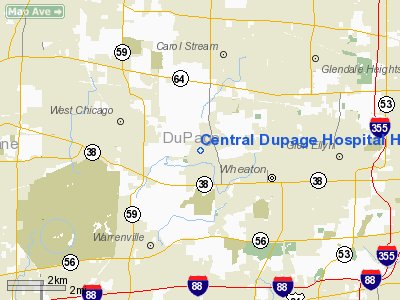
Location
& QuickFacts
|
FAA
Information Effective: |
2007-07-05 |
|
Airport
Identifier: |
IS39 |
|
Airport
Status: |
Operational |
|
Longitude/Latitude: |
088-09-23.2520W/41-52-28.1030N
-88.156459/41.874473 (Estimated) |
|
Elevation: |
734 ft / 223.72 m (Estimated) |
|
Land: |
0 acres |
|
From
nearest city: |
0 nautical miles N of Winfield, IL |
|
Location: |
Du Page County, IL |
|
Magnetic Variation: |
01W (1990) |
Owner
& Manager
|
Ownership: |
Privately
owned |
|
Owner: |
Central Dupage Hospital |
|
Address: |
25 N Winfield Road
Winfield, IL 60190 |
|
Phone
number: |
630-682-1600 |
|
Manager: |
William O'connor |
|
Address: |
25 N Winfield Road
Winfield, IL 60190 |
|
Phone number: |
630-682-1600 |
Airport Operations and Facilities
|
Airport
Use: |
Private
MEDICAL USE |
|
Wind
indicator: |
Yes |
|
Segmented Circle: |
No |
|
Control
Tower: |
No |
|
Lighting
Schedule: |
PHONE REQ
FOR ROTG BCN & PERIMETER LGTS CALL 708-682-1600. |
|
Beacon
Color: |
Clear-Green-Yellow (heliport) |
|
Sectional chart: |
Chicago |
|
Region: |
AGL - Great Lakes |
|
Boundary
ARTCC: |
ZAU - Chicago |
|
Tie-in
FSS: |
IKK - Kankakee |
|
FSS
Toll Free: |
1-800-WX-BRIEF |
|
Runway Information
Helipad H1
|
Dimension: |
45
x 45 ft / 13.7 x 13.7 m |
|
Surface: |
CONC, |
|
|
Runway H1 |
Runway |
|
Traffic
Pattern: |
Left |
Left |
|
Radio Navigation
Aids
|
ID |
Type |
Name |
Ch |
Freq |
Var |
Dist |
|
ME |
NDB |
Deana |
|
350.00 |
00E |
8.1 nm |
|
HK |
NDB |
Ermin |
|
332.00 |
01W |
17.1 nm |
|
MX |
NDB |
Kedzi |
|
248.00 |
01W |
22.4 nm |
|
DKB |
NDB |
Dekalb |
|
209.00 |
02W |
24.9 nm |
|
OIX |
NDB |
Ottawa |
|
266.00 |
01E |
43.9 nm |
|
RA |
NDB |
Paser |
|
206.00 |
00E |
49.9 nm |
|
DPA |
VOR/DME |
Dupage |
021X |
108.40 |
02E |
8.7 nm |
|
ORD |
VOR/DME |
Chicago O'hare |
086X |
113.90 |
02E |
13.1 nm |
|
OBK |
VOR/DME |
Northbrook |
077X |
113.00 |
02W |
22.8 nm |
|
ENW |
VOR/DME |
Kenosha |
029X |
109.20 |
02W |
44.7 nm |
|
BUU |
VOR/DME |
Burbun |
092X |
114.50 |
01W |
49.4 nm |
|
JOT |
VORTAC |
Joliet |
070X |
112.30 |
02E |
21.0 nm |
|
CGT |
VORTAC |
Chicago Heights |
089X |
114.20 |
02E |
34.2 nm |
|
EON |
VORTAC |
Peotone |
079X |
113.20 |
02E |
39.9 nm |
|
ORD |
VOT |
Chicago O'hare Intl |
|
112.00 |
|
12.9 nm |
|
MDW |
VOT |
Chicago Midway |
|
111.00 |
|
18.9 nm |
Remarks
- PRVDD
APCH/DEP RTE OPS FM 360 TO 020 & FM 170 TO 190 TKOF/LDG AREA MKD:
& WIND IND IS MAINTAINED.
Central Dupage Hospital Heliport
Address:
Du Page County, IL
Tel:
630-682-1600
Images
and information placed above are from
http://www.airport-data.com/airport/IS39/
We
thank them for the data!
| General
Info |
| Country |
United
States |
| State |
ILLINOIS
|
| FAA ID |
IS39 |
| Latitude |
41-52-28.103N
|
| Longitude |
088-09-23.252W
|
| Elevation |
734 feet
|
| Near City |
WINFIELD
|
We don't guarantee the information is fresh and accurate. The data may
be wrong or outdated.
For more up-to-date information please refer to other sources.
|
|


