 |
|
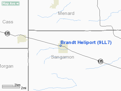
Location
& QuickFacts
|
FAA
Information Effective: |
2007-07-05 |
|
Airport
Identifier: |
9LL7 |
|
Airport
Status: |
Operational |
|
Longitude/Latitude: |
089-55-28.3960W/39-52-38.1760N
-89.924554/39.877271 (Estimated) |
|
Elevation: |
629 ft / 191.72 m (Estimated) |
|
Land: |
2 acres |
|
From
nearest city: |
1 nautical miles NW of Pleasant Plains, IL |
|
Location: |
Sangamon County, IL |
|
Magnetic Variation: |
01E (1985) |
Owner & Manager
|
Ownership: |
Privately owned |
|
Owner: |
Perkinson Copters, Inc. |
|
Address: |
Po Box 338
Warrensburg, IL 62573 |
|
Phone number: |
217-672-3512 |
|
Manager: |
Roy S. Phillips |
|
Address: |
Po Box 338
Warrensburg, IL 62573 |
|
Phone number: |
217-672-3512 |
Airport
Operations and Facilities
|
Airport
Use: |
Private |
|
Wind
indicator: |
No |
|
Segmented Circle: |
No |
|
Control
Tower: |
No |
|
Sectional chart: |
St Louis |
|
Region: |
AGL - Great Lakes |
|
Boundary
ARTCC: |
ZKC - Kansas City |
|
Tie-in
FSS: |
STL - Saint Louis |
|
FSS
on Airport: |
No |
|
FSS
Phone: |
636-536-2980 |
|
FSS
Toll Free: |
1-800-WX-BRIEF |
|
Runway Information
Helipad H1
|
Dimension: |
300
x 150 ft / 91.4 x 45.7 m |
|
Surface: |
TURF, |
|
|
Runway H1 |
Runway |
|
Traffic
Pattern: |
Left |
Left |
|
Radio Navigation
Aids
|
ID |
Type |
Name |
Ch |
Freq |
Var |
Dist |
|
SP |
NDB |
Huskk |
|
382.00 |
01W |
9.8 nm |
|
LQ |
NDB |
Licol |
|
375.00 |
01W |
15.0 nm |
|
AAA |
NDB |
Abraham |
|
329.00 |
00E |
31.9 nm |
|
TAZ |
NDB |
Taylorville |
|
395.00 |
00E |
34.5 nm |
|
CTK |
NDB |
Canton |
|
236.00 |
02E |
42.0 nm |
|
PPQ |
NDB |
Pittsfield |
|
344.00 |
02E |
42.1 nm |
|
LTD |
NDB |
Litchfield |
|
371.00 |
01E |
44.3 nm |
|
PI |
NDB |
Tungg |
|
356.00 |
01E |
46.3 nm |
|
JZY |
NDB |
Macomb |
|
251.00 |
01E |
48.3 nm |
|
IJX |
VOR/DME |
Jacksonville |
023X |
108.60 |
02E |
15.7 nm |
|
SPI |
VORTAC |
Spinner |
74X |
112.70 |
01W |
11.6 nm |
|
CAP |
VORTAC |
Capital |
074X |
112.70 |
04E |
13.8 nm |
|
PIA |
VORTAC |
Peoria |
099X |
115.20 |
04E |
48.6 nm |
Remarks
- ALL
INGRESS/EGRESS OPERATIONS ARE CONDUCTED ONLY ON BEARINGS OF 050 OR 310
DEGS FROM THE HELIPAD USING THE HELIPAD AS THE CENTER OF A COMPASS ROSE.
Brandt Sangamon Heliport
Address:
Sangamon County, IL
Tel:
217-672-3512
Images
and information placed above are from
http://www.airport-data.com/airport/9LL7/
We
thank them for the data!
| General
Info |
| Country |
United
States |
| State |
ILLINOIS
|
| FAA ID |
9LL7 |
| Latitude |
39-52-38.176N
|
| Longitude |
089-55-28.396W
|
| Elevation |
629 feet
|
| Near City |
PLEASANT
PLAINS |
We don't guarantee the information is fresh and accurate. The data may
be wrong or outdated.
For more up-to-date information please refer to other sources.
|
|


