|
|
Bolingbrook's Clow International Airport |
Bolingbrook's
Clow International Airport |
| IATA: none â ICAO: none â FAA LID: 1C5 |
| Summary |
| Airport type |
Public |
| Owner |
Village of Bolingbrook |
| Serves |
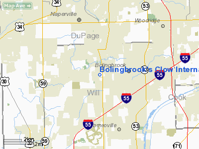
Bolingbrook, Illinois |
| Elevation AMSL |
670 ft / 204 m |
| Coordinates |
41°41â²46â³N 088°07â²45â³W / 41.69611°N 88.12917°W / 41.69611; -88.12917 |
| Website |
www.ClowAirport.com |
| Runways |
| Direction |
Length |
Surface |
| ft |
m |
| 18/36 |
3,362 |
1,025 |
Asphalt |
| Statistics (2005) |
| Aircraft operations |
50,000 |
| Based aircraft |
145 |
| Source: FAA and airport web site |
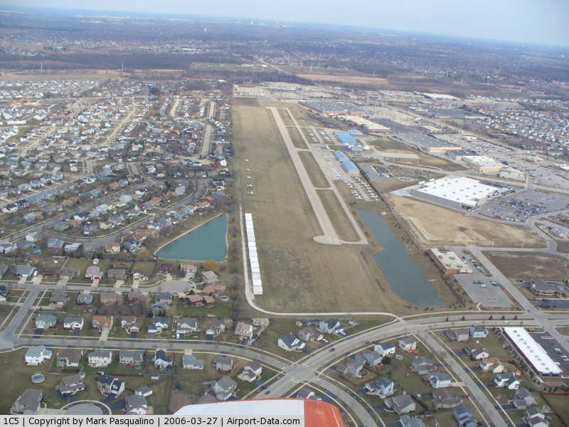
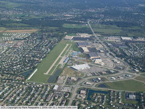
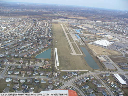
Runway diagram Bolingbrook's Clow International Airport (FAA LID: 1C5) is a public airport in Bolingbrook, a village in Will County, Illinois, United States. Located 29 miles (46 km) southwest of the Chicago Loop, it is a small general aviation facility catering to private pilots, students, and commuter aircraft. It is also the location of the Illinois Aviation Museum at Bolingbrook.
Clow features a $100 hamburger diner, Charlie's Restaurant, which serves breakfast and lunch. History
The airport was originally a grass airstrip built by Oliver Boyd Clow in the 1950s. By 1989 it was named the best privately-owned, public use airport in Illinois. The airport was acquired by the Village of Bolingbrook in 2004. The village intends to expand the airport, which will include steps such as widening the runway, adding runway, taxiway, and landing glidepath lighting.
The airport was used as a location for the 1992 film Folks! with Tom Selleck and Don Ameche, which also had a cameo by O. Boyd Clow, the founder of the airport.
Facilities and aircraft
Bolingbrook's Clow International Airport covers an area of 205 acres (83 ha) and contains one runway designated 18/36 with a 3,362 x 50 ft (1,025 x 15 m) asphalt pavement.
For the 12-month period ending December 31, 2005, the airport had 50,000 aircraft operations, an average of 136 per day: 96% general aviation and 4% air taxi. There are 145 aircraft based at this airport: 83% single-engine, 10% ultralight, 3% multi-engine and 3% helicopter. The Fixed-Based Operator (FBO) at Clow is A&M Aviation.
The above content comes from Wikipedia and is published under free licenses – click here to read more.
|
 |
(Click on the photo to enlarge) |
|
 |
(Click on the photo to enlarge) |
Location
& QuickFacts
|
FAA
Information Effective: |
2007-07-05 |
|
Airport
Identifier: |
1C5 |
|
Airport
Status: |
Operational |
|
Longitude/Latitude: |
088-07-45.2300W/41-41-45.5080N
-88.129231/41.695974 (Estimated) |
|
Elevation: |
670 ft / 204.22 m (Estimated) |
|
Land: |
205 acres |
|
From
nearest city: |
0 nautical miles NW of Bolingbrook, IL |
|
Location: |
Will County, IL |
|
Magnetic Variation: |
02E (1965) |
Owner
& Manager
|
Ownership: |
Publicly
owned |
|
Owner: |
Village Of Bolingbrook |
|
Address: |
375 W Briarcliff Road
Bolingbrook, IL 60440 |
|
Phone
number: |
630-226-8400 |
|
Manager: |
Joseph Depaulo |
|
Address: |
130 S Clow Intl Parkway
Bolingbrook, IL 60490 |
|
Phone number: |
630-378-0479 |
Airport Operations and Facilities
|
Airport
Use: |
Open
to public |
|
Wind
indicator: |
Yes |
|
Segmented Circle: |
No |
|
Control
Tower: |
No |
|
Lighting
Schedule: |
DUSK-DAWN |
|
Beacon
Color: |
Clear-Green (lighted land airport) |
|
Landing
fee charge: |
No |
|
Sectional chart: |
Chicago |
|
Region: |
AGL - Great Lakes |
|
Traffic
Pattern Alt: |
600 ft |
|
Boundary
ARTCC: |
ZAU - Chicago |
|
Tie-in
FSS: |
IKK - Kankakee |
|
FSS
on Airport: |
No |
|
FSS
Toll Free: |
1-800-WX-BRIEF |
|
NOTAMs
Facility: |
IKK (NOTAM-d service avaliable) |
|
Federal Agreements: |
N |
Airport Communications
Airport
Services
|
Fuel
available: |
100LLA |
|
Airframe
Repair: |
MAJOR |
|
Power
Plant Repair: |
MAJOR |
|
Bottled
Oxygen: |
NONE |
|
Bulk
Oxygen: |
NONE |
|
Runway Information
Runway 18/36
|
Dimension: |
3362
x 50 ft / 1024.7 x 15.2 m |
|
Surface: |
ASPH, Good Condition |
|
Edge
Lights: |
Non-standard lighting system
NSTD LIRL, SPACING AND INTENSITY VARIES. |
|
|
Runway 18 |
Runway 36 |
|
Longitude: |
088-07-45.8190W |
088-07-44.5540W |
|
Latitude: |
41-42-02.0850N |
41-41-28.8860N |
|
Elevation: |
670.00 ft |
653.00 ft |
|
Alignment: |
127 |
127 |
|
Traffic
Pattern: |
Left |
Left |
|
Markings: |
Numbers only, Fair Condition |
Numbers only, Fair Condition |
|
Displaced
threshold: |
190.00 ft |
0.00 ft |
|
Obstruction: |
22 ft tree, 428.0 ft from runway, 107 ft left
of centerline, 10:1 slope to clear
APCH SLOPE TO DSPLCD THLD 28:1. |
25 ft bldg, 660.0 ft from runway, 113 ft left
of centerline, 18:1 slope to clear |
|
Radio Navigation
Aids
|
ID |
Type |
Name |
Ch |
Freq |
Var |
Dist |
|
HK |
NDB |
Ermin |
|
332.00 |
01W |
13.2 nm |
|
ME |
NDB |
Deana |
|
350.00 |
00E |
17.0 nm |
|
MX |
NDB |
Kedzi |
|
248.00 |
01W |
19.9 nm |
|
DKB |
NDB |
Dekalb |
|
209.00 |
02W |
29.6 nm |
|
OIX |
NDB |
Ottawa |
|
266.00 |
01E |
38.3 nm |
|
DPA |
VOR/DME |
Dupage |
021X |
108.40 |
02E |
15.3 nm |
|
ORD |
VOR/DME |
Chicago O'hare |
086X |
113.90 |
02E |
20.2 nm |
|
OBK |
VOR/DME |
Northbrook |
077X |
113.00 |
02W |
32.6 nm |
|
IKK |
VOR/DME |
Kankakee |
053X |
111.60 |
00E |
39.4 nm |
|
JOT |
VORTAC |
Joliet |
070X |
112.30 |
02E |
12.4 nm |
|
CGT |
VORTAC |
Chicago Heights |
089X |
114.20 |
02E |
27.4 nm |
|
EON |
VORTAC |
Peotone |
079X |
113.20 |
02E |
29.8 nm |
|
MDW |
VOT |
Chicago Midway |
|
111.00 |
|
17.8 nm |
|
ORD |
VOT |
Chicago O'hare Intl |
|
112.00 |
|
19.9 nm |
Remarks
- TFC
PATTERNS SOUTH OF ARPT SHALL REMAIN WITHIN 3/4 MI.
Based Aircraft
|
Aircraft
based on field: |
145 |
|
Single
Engine Airplanes: |
120 |
|
Multi
Engine Airplanes: |
5 |
|
Helicopters: |
5 |
|
Ultralights: |
15 |
Operational Statistics
Time Period: 2005-01-01
- 2005-12-31
|
Aircraft
Operations: |
137/Day |
|
Air
Taxi: |
4.0% |
|
General
Aviation Local: |
52.0% |
|
General
Aviation Itinerant: |
44.0% |
Bolingbrook's Clow International Airport
Address:
Will County, IL
Tel:
630-226-8400,
630-378-0479
Images
and information placed above are from
http://www.airport-data.com/airport/1C5/
We
thank them for the data!
| General
Info |
| Country |
United
States |
| State |
ILLINOIS
|
| FAA ID |
1C5 |
| Time |
UTC-6(-5DT)
|
| Latitude |
41.695975
41° 41' 45.51" N |
| Longitude |
-88.129231
088° 07' 45.23" W |
| Elevation |
670 feet
204 meters |
| Magnetic
Variation |
002° W
(01/06) |
| Beacon |
Yes |
| Operating
Agency |
U.S.CIVIL
AIRPORT WHEREIN PERMIT COVERS USE BY TRANSIT MILITARY AIRCRAFT |
| Near City |
Bolingbrook
|
| Operating
Hours |
SEE REMARKS
FOR OPERATING HOURS OR COMMUNICATIONS FOR POSSIBLE HOURS |
| Daylight
Saving Time |
Second
Sunday in March at 0200 to first Sunday in November at 0200 local
time (Exception Arizona and that portion of Indiana in the Eastern
Time Zone) |
We don't guarantee the information is fresh and accurate. The data may
be wrong or outdated.
For more up-to-date information please refer to other sources.
|
|