|
|
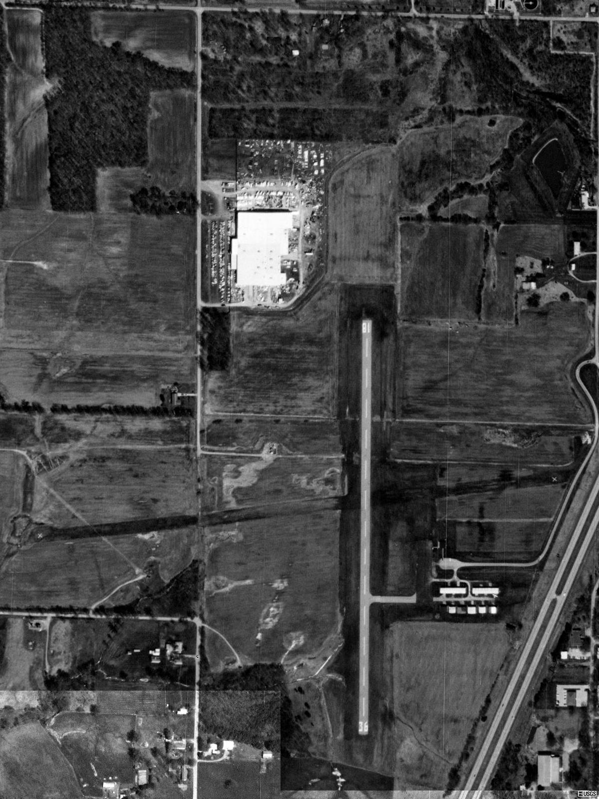
| Benton Municipal Airport |
 |
| USGS aerial image - 6 April 1998 |
| IATA: none – ICAO: none – FAA LID: H96 |
| Summary |
| Airport type |
Public |
| Owner |
City of Benton |
| Serves |
Benton, Illinois |
| Elevation AMSL |
444 ft / 135 m |
| Coordinates |
38°00′24″N 088°56′04″W / 38.00667°N 88.93444°W / 38.00667; -88.93444 |
| Runways |
| Direction |
Length |
Surface |
| ft |
m |
| 18/36 |
4,000 |
1,219 |
Asphalt |
| Statistics (2007) |
| Aircraft operations |
8,000 |
| Based aircraft |
10 |
| Source: Federal Aviation Administration |
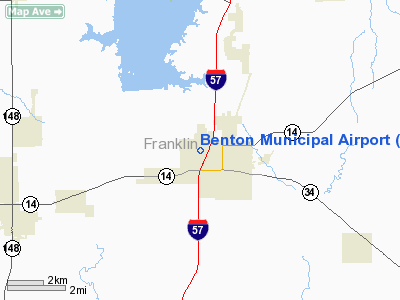
Benton Municipal Airport (FAA LID: H96) is a city-owned public-use airport located 1 nautical mile (1.9 km; 1.2 mi) west of the central business district of Benton, a city in Franklin County, Illinois, United States. This airport is included in the FAA's National Plan of Integrated Airport Systems (2009-2013), which categorizes it as a general aviation airport.
Facilities and aircraft
Benton Municipal Airport covers an area of 110 acres (45 ha) at an elevation of 444 feet (135 m) above mean sea level. It has one runway designated 18/36 with an asphalt surface measuring 4,000 by 75 feet (1,219 x 23 m). The runway was expanded in 2003; it previously measured 2,720 by 60 feet (829 x 18 m).
For the 12-month period ending August 31, 2007, the airport had 8,000 aircraft operations, an average of 21 per day: 94% general aviation, 5% air taxi and 1% military. At that time there were 10 aircraft based at this airport: 9 single-engine and 1 multi-engine.
The above content comes from Wikipedia and is published under free licenses – click here to read more.
Location
& QuickFacts
|
FAA
Information Effective: |
2007-07-05 |
|
Airport
Identifier: |
H96 |
|
Airport
Status: |
Operational |
|
Longitude/Latitude: |
088-56-03.8950W/38-00-24.3040N
-88.934415/38.006751 (Estimated) |
|
Elevation: |
444 ft / 135.33 m (Surveyed) |
|
Land: |
110 acres |
|
From
nearest city: |
1 nautical miles W of Benton, IL |
|
Location: |
Franklin County, IL |
|
Magnetic Variation: |
02E (1980) |
Owner
& Manager
|
Ownership: |
Publicly
owned |
|
Owner: |
City Of Benton |
|
Address: |
P.o. Box 640-city Hall
Benton, IL 62812 |
|
Phone
number: |
618-439-6131 |
|
Manager: |
Earl Sandusky |
|
Address: |
P.o. Box 158
Benton, IL 62812 |
|
Phone number: |
618-435-3526
IF NO ANSWR, CALL 618-439-6409. |
Airport
Operations and Facilities
|
Airport
Use: |
Open
to public |
|
Wind
indicator: |
Yes
OTS INDEFLY. |
|
Segmented Circle: |
No |
|
Control
Tower: |
No |
|
Lighting
Schedule: |
DUSK-DAWN
MIRL RY 18/36 PRESET ON LOW INTST; TO INCR INTST ACTVT -
CTAF. |
|
Beacon
Color: |
Clear-Green (lighted land airport) |
|
Landing
fee charge: |
No |
|
Sectional chart: |
St Louis |
|
Region: |
AGL - Great Lakes |
|
Traffic
Pattern Alt: |
800 ft |
|
Boundary
ARTCC: |
ZKC - Kansas City |
|
Tie-in
FSS: |
STL - Saint Louis |
|
FSS
on Airport: |
No |
|
FSS
Phone: |
636-536-2980 |
|
FSS
Toll Free: |
1-800-WX-BRIEF |
|
NOTAMs
Facility: |
STL (NOTAM-d service avaliable) |
|
Federal Agreements: |
NGY |
Airport Communications
|
CTAF: |
122.800 |
|
Unicom: |
122.800
|
Airport
Services
|
Runway Information
Runway 18/36
|
Dimension: |
4000
x 75 ft / 1219.2 x 22.9 m |
|
Surface: |
ASPH, Good Condition |
|
Weight
Limit: |
Single wheel: 4000 lbs. |
|
Edge
Lights: |
Medium |
|
|
Runway 18 |
Runway 36 |
|
Longitude: |
088-56-04.3140W |
088-56-03.6780W |
|
Latitude: |
38-00-50.3970N |
38-00-10.8480N |
|
Elevation: |
442.00 ft |
444.00 ft |
|
Alignment: |
127 |
127 |
|
Traffic
Pattern: |
Left |
Left |
|
Markings: |
Basic, Good Condition |
Basic, Good Condition |
|
Runway
End Identifier: |
No |
No |
|
Centerline
Lights: |
No |
No |
|
Touchdown
Lights: |
No |
No |
|
Obstruction: |
40 ft pline, 1000.0 ft from runway, 20:1 slope
to clear |
69 ft tree, 847.0 ft from runway, 193 ft right
of centerline, 9:1 slope to clear |
|
Radio Navigation
Aids
|
ID |
Type |
Name |
Ch |
Freq |
Var |
Dist |
|
PJY |
NDB |
Pinckneyville |
|
215.00 |
00E |
20.4 nm |
|
HSB |
NDB |
Harrisburg-raleigh |
|
230.00 |
00E |
21.9 nm |
|
FWC |
NDB |
Wayne County |
|
257.00 |
01E |
33.4 nm |
|
SAR |
NDB |
Sparta |
|
239.00 |
01E |
37.3 nm |
|
SLO |
NDB |
Salem |
|
400.00 |
01W |
38.3 nm |
|
CUL |
NDB |
Carmi |
|
332.00 |
01W |
38.9 nm |
|
FOA |
NDB |
Elm River |
|
353.00 |
00E |
45.8 nm |
|
BL |
NDB |
Belleville |
|
362.00 |
02E |
47.6 nm |
|
MWA |
VOR/DME |
Marion |
041X |
110.40 |
04E |
15.6 nm |
|
VNN |
VOR/DME |
Mount Vernon |
085X |
113.80 |
02E |
22.2 nm |
|
SAM |
VOR/DME |
Samsville |
113X |
116.60 |
03E |
49.3 nm |
|
ENL |
VORTAC |
Centralia |
097X |
115.00 |
04E |
27.0 nm |
Based
Aircraft
|
Aircraft
based on field: |
11 |
|
Single
Engine Airplanes: |
11 |
Operational Statistics
Time Period: 2003-08-02
- 2004-07-31
|
Aircraft
Operations: |
154/Week |
|
Air
Taxi: |
5.0% |
|
General
Aviation Local: |
49.4% |
|
General
Aviation Itinerant: |
45.0% |
|
Military: |
0.6% |
Benton Municipal Airport
Address:
Franklin County, IL
Tel:
618-439-6131,
618-435-3526
Images
and information placed above are from
http://www.airport-data.com/airport/H96/
We
thank them for the data!
| General
Info |
| Country |
United
States |
| State |
ILLINOIS
|
| FAA ID |
H96 |
| Latitude |
38-00-24.304N
|
| Longitude |
088-56-03.895W
|
| Elevation |
444 feet
|
| Near City |
BENTON
|
We don't guarantee the information is fresh and accurate. The data may
be wrong or outdated.
For more up-to-date information please refer to other sources.
|
|