|
|
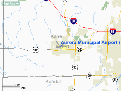
| Chicago/Aurora Municipal Airport |
 |
| IATA: AUZ â ICAO: KARR â FAA LID: ARR |
| Summary |
| Airport type |
Public |
| Owner/Operator |
City of Aurora, Illinois |
| Serves |
Chicago / Aurora |
| Location |
Sugar Grove, Illinois |
| Elevation AMSL |
712 ft / 217 m |
| Coordinates |
41°46â²19â³N 088°28â²32â³W / 41.77194°N 88.47556°W / 41.77194; -88.47556 |
| Website |
www.auroraairport.com |
| Runways |
| Direction |
Length |
Surface |
| ft |
m |
| 9/27 |
6,501 |
1,982 |
Concrete |
| 15/33 |
5,503 |
1,677 |
Concrete |
| 18/36 |
3,198 |
975 |
Asphalt |
| Statistics (2007) |
| Aircraft operations |
66,582 |
| Based aircraft |
259 |
| Source: FAA |
Chicago/Aurora Municipal Airport (IATA: AUZ, ICAO: KARR, FAA LID: ARR) is a public airport opened in April 1966, located in the village of Sugar Grove, Illinois, United States, 8 miles (13 km) west of the city of Aurora, both in Kane County. The airport is owned and operated by the City of Aurora. It is 50 miles (80 km) west of Chicago and is designated as a reliever airport for Chicago's O'Hare and Midway airports. Although most U.S. airports use the same three-letter location identifier for both the FAA and IATA, Chicago/Aurora Municipal Airport is assigned ARR by the FAA and AUZ by the IATA (which assigned ARR to Alto RÃo Senguer, Argentina). The airport's ICAO identifier is KARR. Facilities and aircraft
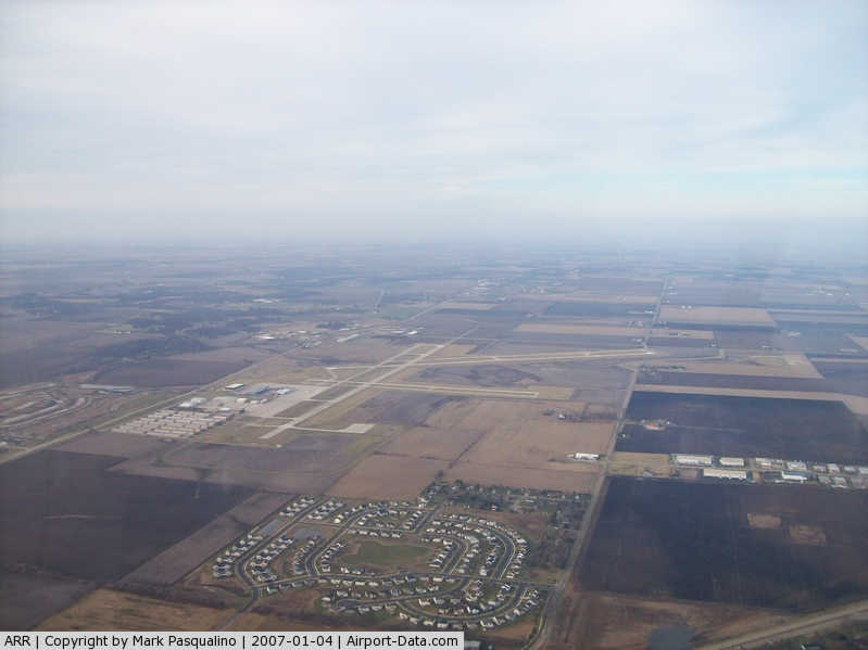
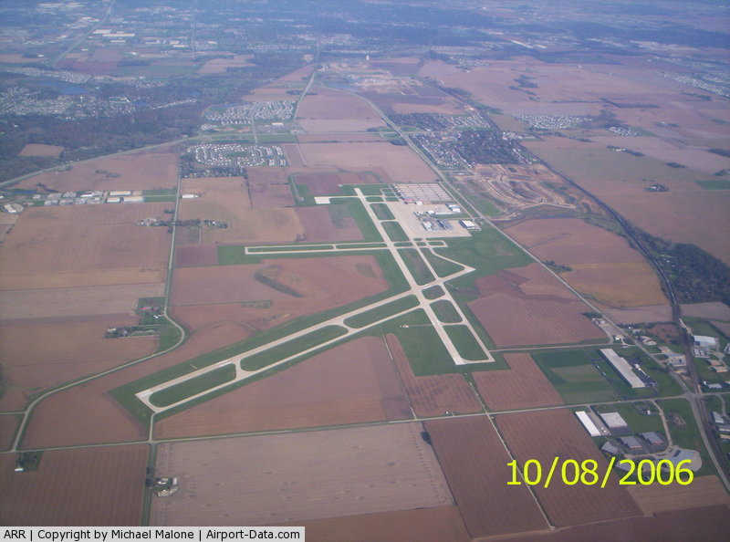
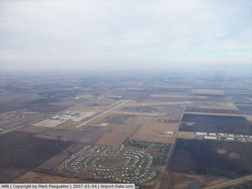
Aurora Municipal Airport covers an area of 1,100 acres (450 ha), which contains three runways:
- Runway 9/27: 6,501 x 100 ft (1,982 x 30 m), Surface: Concrete
- Runway 15/33: 5,503 x 100 ft (1,677 x 30 m), Surface: Concrete
- Runway 18/36: 3,198 x 75 ft (975 x 23 m), Surface: Asphalt
Current project planning calls for a parallel grass runway (9L/27R) during fiscal years 2010-2012. For the 12-month period ending May 31, 2007, the airport had 66,582 aircraft operations, an average of 182 per day: 98% general aviation, 1% air taxi and <1% military. There are 259 aircraft based at this airport: 75% single engine, 19% multi-engine, 6% jet aircraft and <1% helicopters. J.A. Air Center and Lumanair are the airport's two fixed base operators (FBO).
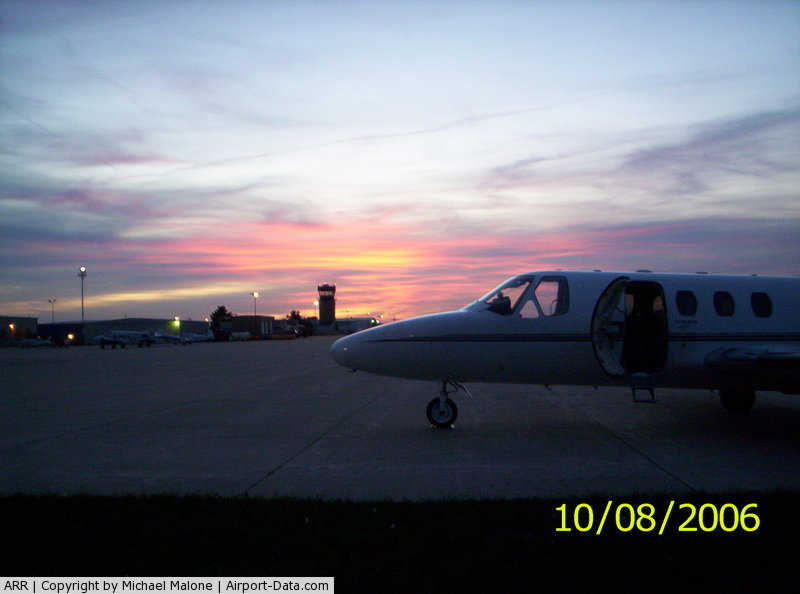
Gallery
The above content comes from Wikipedia and is published under free licenses – click here to read more.
|
 |
(Click on the photo to enlarge) |
|
 |
(Click on the photo to enlarge) |
|
 |
(Click on the photo to enlarge) |
|
 |
(Click on the photo to enlarge) |
Location
& QuickFacts
|
FAA
Information Effective: |
2007-07-05 |
|
Airport
Identifier: |
ARR |
|
Airport
Status: |
Operational |
|
Longitude/Latitude: |
088-28-32.4000W/41-46-19.0000N
-88.475667/41.771944 (Estimated) |
|
Elevation: |
712 ft / 217.02 m (Surveyed) |
|
Land: |
1100 acres |
|
From
nearest city: |
38 nautical miles W of Chicago/aurora, IL |
|
Location: |
Kane County, IL |
|
Magnetic Variation: |
01W (1990) |
Owner
& Manager
|
Ownership: |
Publicly
owned |
|
Owner: |
City Of Aurora |
|
Address: |
44 E. Downer Place
Aurora, IL 60507 |
|
Phone
number: |
630-844-3612 |
|
Manager: |
Bob Rieser |
|
Address: |
43w 636 Us30
Sugar Grove, IL 60554 |
|
Phone number: |
630-466-7000 |
Airport Operations and Facilities
|
Airport
Use: |
Open
to public |
|
Wind
indicator: |
Yes |
|
Segmented Circle: |
Yes |
|
Control
Tower: |
Yes |
|
Lighting
Schedule: |
DUSK-DAWN
WHEN ATCT CLSD HIRL RYS 15/33 & 09/27 & MIRL RY
18/36 PRESET LOW INTST; TO INCR INTST & ACTVT MALSR
RY 09; REIL RYS 18;36,15,33 & 27, AND TWY LGTS - CTAF. |
|
Beacon
Color: |
Clear-Green (lighted land airport) |
|
Landing
fee charge: |
No |
|
Sectional chart: |
Chicago |
|
Region: |
AGL - Great Lakes |
|
Boundary
ARTCC: |
ZAU - Chicago |
|
Tie-in
FSS: |
IKK - Kankakee |
|
FSS
on Airport: |
No |
|
FSS
Toll Free: |
1-800-WX-BRIEF |
|
NOTAMs
Facility: |
ARR (NOTAM-d service avaliable) |
|
Federal Agreements: |
NGY |
Airport Communications
|
CTAF: |
120.600 |
|
Unicom: |
122.950
ADDNL UNICOM FREQ IS 123.50. |
Airport Services
|
Fuel
available: |
100
A1 |
|
Airframe
Repair: |
MAJOR |
|
Power
Plant Repair: |
MAJOR |
|
Bottled
Oxygen: |
HIGH/LOW |
|
Bulk
Oxygen: |
HIGH/LOW |
|
Runway Information
Runway 09/27
|
Dimension: |
6501
x 100 ft / 1981.5 x 30.5 m |
|
Surface: |
CONC, Good Condition |
|
Surface
Treatment: |
Saw-cut or plastic Grooved |
|
Weight
Limit: |
Single wheel: 30000 lbs.
Dual wheel: 130000 lbs. |
|
Edge
Lights: |
High |
|
|
Runway 09 |
Runway 27 |
|
Longitude: |
088-29-07.3200W |
088-27-41.5340W |
|
Latitude: |
41-46-12.5540N |
41-46-13.5120N |
|
Elevation: |
706.00 ft |
706.00 ft |
|
Alignment: |
89 |
127 |
|
ILS
Type: |
ILS |
|
|
Traffic
Pattern: |
Left |
Left |
|
Markings: |
Precision instrument, Good Condition |
Precision instrument, Good Condition |
|
Crossing
Height: |
45.00 ft |
42.00 ft |
|
VASI: |
4-light PAPI on left side |
4-box on left side |
|
Visual
Glide Angle: |
3.00° |
3.00° |
|
Approach
lights: |
MALSR |
|
|
Runway
End Identifier: |
No |
Yes |
|
Centerline
Lights: |
No |
No |
|
Touchdown
Lights: |
No |
No |
|
Runway 15/33
|
Dimension: |
5502
x 100 ft / 1677.0 x 30.5 m |
|
Surface: |
CONC, Good Condition |
|
Surface
Treatment: |
Saw-cut or plastic Grooved |
|
Weight
Limit: |
Dual wheel: 130000 lbs. |
|
Edge
Lights: |
High |
|
|
Runway 15 |
Runway 33 |
|
Longitude: |
088-29-10.1700W |
088-28-30.3090W |
|
Latitude: |
41-46-48.1030N |
41-46-02.6610N |
|
Elevation: |
712.00 ft |
698.00 ft |
|
Alignment: |
127 |
127 |
|
Traffic
Pattern: |
Left |
Left |
|
Markings: |
Non-precision instrument, Good Condition |
Non-precision instrument, Good Condition |
|
Crossing
Height: |
34.00 ft |
32.00 ft |
|
VASI: |
4-light PAPI on left side |
4-light PAPI on left side |
|
Visual
Glide Angle: |
3.00° |
3.00° |
|
Runway
End Identifier: |
Yes |
Yes |
|
Obstruction: |
53 ft tree, 1323.0 ft from runway, 386 ft right
of centerline, 21:1 slope to clear |
34 ft pole, 1156.0 ft from runway, 272 ft left
of centerline, 28:1 slope to clear |
|
Runway 18/36
|
Dimension: |
3199
x 75 ft / 975.1 x 22.9 m |
|
Surface: |
ASPH, Fair Condition |
|
Weight
Limit: |
Single wheel: 30000 lbs. |
|
Edge
Lights: |
Medium |
|
|
Runway 18 |
Runway 36 |
|
Longitude: |
088-28-17.8290W |
088-28-17.7850W |
|
Latitude: |
41-46-35.6980N |
41-46-04.0950N |
|
Elevation: |
700.00 ft |
700.00 ft |
|
Alignment: |
127 |
127 |
|
Traffic
Pattern: |
Left |
Left |
|
Markings: |
Basic, Fair Condition |
Non-precision instrument, Fair Condition |
|
Crossing
Height: |
30.00 ft |
34.00 ft |
|
VASI: |
4-box on left side |
4-box on left side |
|
Visual
Glide Angle: |
3.00° |
3.00° |
|
Runway
End Identifier: |
Yes |
Yes |
|
Centerline
Lights: |
No |
No |
|
Touchdown
Lights: |
No |
No |
|
Obstruction: |
39 ft pole, 1129.0 ft from runway, 296 ft right
of centerline, 23:1 slope to clear
RISING GROUND +6 FEET. |
34 ft pline, 1248.0 ft from runway, 370 ft
left of centerline, 30:1 slope to clear |
|
Radio Navigation
Aids
|
ID |
Type |
Name |
Ch |
Freq |
Var |
Dist |
|
DKB |
NDB |
Dekalb |
|
209.00 |
02W |
14.2 nm |
|
ME |
NDB |
Deana |
|
350.00 |
00E |
23.3 nm |
|
HK |
NDB |
Ermin |
|
332.00 |
01W |
28.8 nm |
|
OIX |
NDB |
Ottawa |
|
266.00 |
01E |
29.9 nm |
|
MX |
NDB |
Kedzi |
|
248.00 |
01W |
35.3 nm |
|
VYS |
NDB |
Valley |
|
230.00 |
00W |
39.3 nm |
|
DPA |
VOR/DME |
Dupage |
021X |
108.40 |
02E |
9.1 nm |
|
ORD |
VOR/DME |
Chicago O'hare |
086X |
113.90 |
02E |
28.6 nm |
|
OBK |
VOR/DME |
Northbrook |
077X |
113.00 |
02W |
35.7 nm |
|
RFD |
VOR/DME |
Rockford |
045X |
110.80 |
01E |
42.3 nm |
|
PLL |
VOR/DME |
Polo |
049X |
111.20 |
03E |
48.4 nm |
|
JOT |
VORTAC |
Joliet |
070X |
112.30 |
02E |
15.3 nm |
|
EON |
VORTAC |
Peotone |
079X |
113.20 |
02E |
43.1 nm |
|
CGT |
VORTAC |
Chicago Heights |
089X |
114.20 |
02E |
43.6 nm |
|
ORD |
VOT |
Chicago O'hare Intl |
|
112.00 |
|
28.4 nm |
|
MDW |
VOT |
Chicago Midway |
|
111.00 |
|
32.4 nm |
Remarks
Based
Aircraft
|
Aircraft
based on field: |
293 |
|
Single
Engine Airplanes: |
209 |
|
Multi
Engine Airplanes: |
56 |
|
Jet
Engine Airplanes: |
26 |
|
Helicopters: |
2 |
Operational Statistics
Time Period: 2004-06-01
- 2005-05-31
|
Aircraft
Operations: |
304/Day |
|
Air
Taxi: |
0.6% |
|
General
Aviation Local: |
52.0% |
|
General
Aviation Itinerant: |
47.0% |
|
Military: |
0.4% |
Aurora Municipal Airport
Address:
Kane County, IL
Tel:
630-844-3612,
630-466-7000
Images
and information placed above are from
http://www.airport-data.com/airport/ARR/
We
thank them for the data!
| General
Info |
| Country |
United
States |
| State |
ILLINOIS
|
| FAA ID |
ARR |
| Latitude |
41-46-18.946N
|
| Longitude |
088-28-32.373W
|
| Elevation |
712 feet
|
| Near City |
CHICAGO/AURORA
|
We don't guarantee the information is fresh and accurate. The data may
be wrong or outdated.
For more up-to-date information please refer to other sources.
|
|