 |
|
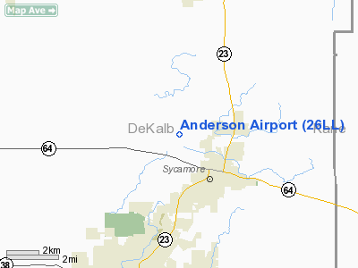
Location
& QuickFacts
|
FAA
Information Effective: |
2007-07-05 |
|
Airport
Identifier: |
26LL |
|
Airport
Status: |
Operational |
|
Longitude/Latitude: |
088-43-03.3180W/42-00-34.1020N
-88.717588/42.009473 (Estimated) |
|
Elevation: |
830 ft / 252.98 m (Estimated) |
|
Land: |
0 acres |
|
From
nearest city: |
2 nautical miles NW of Sycamore, IL |
|
Location: |
De Kalb County, IL |
|
Magnetic Variation: |
00W (1985) |
Owner
& Manager
|
Ownership: |
Privately
owned |
|
Owner: |
Richard Anderson |
|
Address: |
Rr 1 Box 21-1a Motel Rd
Sycamore, IL 60178 |
|
Phone
number: |
815-895-5627 |
|
Manager: |
Richard Anderson |
|
Address: |
Rr 1 Box 21-1a Motel Rd
Sycamore, IL 60178 |
|
Phone number: |
815-895-5627 |
Airport Operations and Facilities
|
Airport
Use: |
Private |
|
Wind
indicator: |
Yes |
|
Segmented Circle: |
No |
|
Control
Tower: |
No |
|
Landing
fee charge: |
No |
|
Sectional chart: |
Chicago |
|
Region: |
AGL - Great Lakes |
|
Boundary
ARTCC: |
ZAU - Chicago |
|
Tie-in
FSS: |
IKK - Kankakee |
|
FSS
on Airport: |
No |
|
FSS
Toll Free: |
1-800-WX-BRIEF |
|
Runway
Information
Runway E/W
|
Dimension: |
1900
x 100 ft / 579.1 x 30.5 m |
|
Surface: |
TURF, |
|
|
Runway E |
Runway W |
|
Traffic
Pattern: |
Left |
Left |
|
Radio Navigation
Aids
|
ID |
Type |
Name |
Ch |
Freq |
Var |
Dist |
|
DKB |
NDB |
Dekalb |
|
209.00 |
02W |
4.6 nm |
|
ME |
NDB |
Deana |
|
350.00 |
00E |
31.0 nm |
|
JVL |
NDB |
Janesville |
|
375.00 |
03E |
39.1 nm |
|
OIX |
NDB |
Ottawa |
|
266.00 |
01E |
39.4 nm |
|
FEP |
NDB |
Freeport |
|
335.00 |
00E |
41.2 nm |
|
LVV |
NDB |
Lake Lawn |
|
404.00 |
00W |
41.8 nm |
|
HK |
NDB |
Ermin |
|
332.00 |
01W |
43.1 nm |
|
VYS |
NDB |
Valley |
|
230.00 |
00W |
43.8 nm |
|
MX |
NDB |
Kedzi |
|
248.00 |
01W |
48.7 nm |
|
DPA |
VOR/DME |
Dupage |
021X |
108.40 |
02E |
17.9 nm |
|
RFD |
VOR/DME |
Rockford |
045X |
110.80 |
01E |
25.1 nm |
|
PLL |
VOR/DME |
Polo |
049X |
111.20 |
03E |
36.1 nm |
|
ORD |
VOR/DME |
Chicago O'hare |
086X |
113.90 |
02E |
36.3 nm |
|
OBK |
VOR/DME |
Northbrook |
077X |
113.00 |
02W |
36.4 nm |
|
JVL |
VOR/DME |
Janesville |
090X |
114.30 |
03E |
37.2 nm |
|
BUU |
VOR/DME |
Burbun |
092X |
114.50 |
01W |
44.8 nm |
|
ENW |
VOR/DME |
Kenosha |
029X |
109.20 |
02W |
49.8 nm |
|
JOT |
VORTAC |
Joliet |
070X |
112.30 |
02E |
33.1 nm |
|
ORD |
VOT |
Chicago O'hare Intl |
|
112.00 |
|
36.2 nm |
|
MDW |
VOT |
Chicago Midway |
|
111.00 |
|
45.2 nm |
Based
Aircraft
|
Aircraft
based on field: |
1 |
|
Single
Engine Airplanes: |
1 |
Anderson Airport
Address:
De Kalb County, IL
Tel:
815-895-5627
Images
and information placed above are from
http://www.airport-data.com/airport/26LL/
We
thank them for the data!
| General
Info |
| Country |
United
States |
| State |
ILLINOIS
|
| FAA ID |
26LL |
| Latitude |
42-00-34.102N
|
| Longitude |
088-43-03.318W
|
| Elevation |
830 feet
|
| Near City |
SYCAMORE
|
We don't guarantee the information is fresh and accurate. The data may
be wrong or outdated.
For more up-to-date information please refer to other sources.
|
|


