 |
|
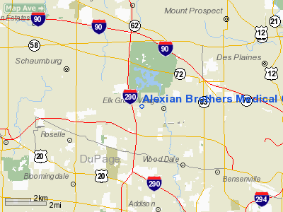
Alexian Brothers Medical Center Heliport |
|
|
Location
& QuickFacts
|
FAA
Information Effective: |
2007-07-05 |
|
Airport
Identifier: |
23IL |
|
Airport
Status: |
Operational |
|
Longitude/Latitude: |
088-01-04.2510W/42-00-18.1020N
-88.017848/42.005028 (Estimated) |
|
Elevation: |
707 ft / 215.49 m (Surveyed) |
|
Land: |
0 acres |
|
From
nearest city: |
2 nautical miles W of Elk Grove Village,
IL |
|
Location: |
Cook County, IL |
|
Magnetic Variation: |
01W (1985) |
Owner
& Manager
|
Ownership: |
Privately
owned |
|
Owner: |
Alexian Brothers Medical Center |
|
Address: |
800 Biesterfield Rd
Elk Grove Village, IL 60007-3397 |
|
Phone
number: |
847-437-5500
EXTENSION 4823. |
|
Manager: |
Mary Ann Magnifico |
|
Address: |
800 Biesterfield Rd
Elk Grove Village, IL 60007-3397 |
|
Phone number: |
847-437-5500
EXTENSION 4823. |
Airport Operations and Facilities
|
Airport
Use: |
Private
MEDICAL USE. |
|
Wind
indicator: |
Yes |
|
Segmented Circle: |
No |
|
Control
Tower: |
No |
|
Lighting
Schedule: |
24 HRS |
|
Beacon
Color: |
Clear-Green-Yellow (heliport) |
|
Sectional chart: |
Chicago |
|
Region: |
AGL - Great Lakes |
|
Boundary
ARTCC: |
ZAU - Chicago |
|
Tie-in
FSS: |
IKK - Kankakee |
|
FSS
Toll Free: |
1-800-WX-BRIEF |
|
Runway Information
Helipad H1
|
Dimension: |
40
x 40 ft / 12.2 x 12.2 m |
|
Surface: |
CONC, |
|
|
Runway H1 |
Runway |
|
Traffic
Pattern: |
Left |
Left |
|
Helipad H2
|
Dimension: |
40
x 40 ft / 12.2 x 12.2 m |
|
Surface: |
CONC, |
|
|
Runway H2 |
Runway |
|
Traffic
Pattern: |
Left |
Left |
|
Radio Navigation
Aids
|
ID |
Type |
Name |
Ch |
Freq |
Var |
Dist |
|
ME |
NDB |
Deana |
|
350.00 |
00E |
2.3 nm |
|
HK |
NDB |
Ermin |
|
332.00 |
01W |
19.0 nm |
|
MX |
NDB |
Kedzi |
|
248.00 |
01W |
21.6 nm |
|
DKB |
NDB |
Dekalb |
|
209.00 |
02W |
31.1 nm |
|
RA |
NDB |
Paser |
|
206.00 |
00E |
41.1 nm |
|
LVV |
NDB |
Lake Lawn |
|
404.00 |
00W |
48.9 nm |
|
ORD |
VOR/DME |
Chicago O'hare |
086X |
113.90 |
02E |
5.2 nm |
|
OBK |
VOR/DME |
Northbrook |
077X |
113.00 |
02W |
13.3 nm |
|
DPA |
VOR/DME |
Dupage |
021X |
108.40 |
02E |
16.4 nm |
|
ENW |
VOR/DME |
Kenosha |
029X |
109.20 |
02W |
35.9 nm |
|
BUU |
VOR/DME |
Burbun |
092X |
114.50 |
01W |
43.0 nm |
|
HRK |
VOR/DME |
Horlick |
124X |
117.70 |
02W |
46.4 nm |
|
JOT |
VORTAC |
Joliet |
070X |
112.30 |
02E |
30.7 nm |
|
CGT |
VORTAC |
Chicago Heights |
089X |
114.20 |
02E |
35.9 nm |
|
EON |
VORTAC |
Peotone |
079X |
113.20 |
02E |
45.4 nm |
|
ORD |
VOT |
Chicago O'hare Intl |
|
112.00 |
|
5.1 nm |
|
MDW |
VOT |
Chicago Midway |
|
111.00 |
|
17.7 nm |
Remarks
- PRVDD
THAT APCH/DEP OPERATIONS CONDUCTED IN 260 DEG TO 280 DEG & 80 DEG
TO 110 DEG; TAKEOFF/LDGAREA IS APPROPLY MKD; MAINTAIN WIND INDICATOR;
UNAUTHORIZED PERSONS & VEHICLES BE RESTRAINED M ACCESS DURING OPERATIONS.
Alexian Brothers Medical Center Heliport
Address:
Cook County, IL
Tel:
847-437-5500
Images
and information placed above are from
http://www.airport-data.com/airport/23IL/
We
thank them for the data!
| General
Info |
| Country |
United
States |
| State |
ILLINOIS
|
| FAA ID |
23IL |
| Latitude |
42-00-18.102N
|
| Longitude |
088-01-04.251W
|
| Elevation |
707 feet
|
| Near City |
ELK GROVE
VILLAGE |
We don't guarantee the information is fresh and accurate. The data may
be wrong or outdated.
For more up-to-date information please refer to other sources.
|
|


