 |
|
Abraham Lincoln Capital Airport |
| Abraham Lincoln Capital Airport |
 |
| IATA: SPI â ICAO: KSPI â FAA LID: SPI |
| Summary |
| Airport type |
Public |
| Owner |
Springfield Airport Authority |
| Serves |
Springfield, Illinois |
| Elevation AMSL |
598 ft / 182 m |
| Coordinates |
39°50â²39â³N 089°40â²41â³W / 39.84417°N 89.67806°W / 39.84417; -89.67806 |
| Website |
www.FlySPI.com |
| Runways |
| Direction |
Length |
Surface |
| ft |
m |
| 4/22 |
8,001 |
2,439 |
Concrete |
| 13/31 |
7,400 |
2,256 |
Asphalt |
| 18/36 |
5,300 |
1,615 |
Asphalt/Concrete |
| Statistics (2009) |
| Aircraft operations |
33,903 |
| Based aircraft |
169 |
| Source: Federal Aviation Administration |
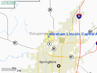
FAA airport diagram Abraham Lincoln Capital Airport (IATA: SPI, ICAO: KSPI, FAA LID: SPI) is a joint civil-military public airport in Sangamon County, Illinois, United States. It is located three nautical miles (6 km) northwest of the central business district of Springfield, the capital city of Illinois. The airport is owned by the Springfield Airport Authority. Military use
The airport home to Capital Airport Air National Guard Station, a 91-acre (370,000 m) facility on land leased from the Springfield Airport Authority. It is home to the 183d Fighter Wing (183 FW), an Illinois Air National Guard unit operationally gained by the Air Combat Command (ACC) and State Headquarters, Illinois Air National Guard. Historically a fighter unit, the 183 FW consists of 321 full-time and 800 part-time military personnel (total strength 1,321). The 183 FW was directed to divest itself of its fighter aircraft pursuant to a Base Realignment and Closure (BRAC) 2005 decision, and in October 2008, the last of the 170th Fighter Squadron's fifteen F-16C/D Fighting Falcon aircraft departed Capital Airport AGS for redistribution to other Air National Guard fighter wings. The 183 FW remains in place at Capital Airport AGS minus a flying mission while the U.S. Air Force, the Air Combat Command and the Air National Guard determine a new role and mission set for the wing. The Illinois Air National Guard State Headquarters, Expeditionary Combat Support (ECS) elements of the 183 FW, the 217th Engineering Installation Squadron and the F110 engine Centralized Intermediate Repair Facility (CIRF) also remain in place at Capital Airport AGS.
Facilities and aircraft
Abraham Lincoln Capital Airport covers an area of 2,300 acres (931 ha) at an elevation of 598 feet (182 m) above mean sea level. It has three runways: 4/22 is 8,001 by 150 feet (2,439 x 46 m) with a concrete surface; 13/31 is 7,400 by 150 feet (2,256 x 46 m) with an asphalt surface; 18/36 is 5,300 by 150 feet (1,615 x 46 m) with an asphalt/concrete surface.
For the 12-month period ending December 31, 2009, the airport had 33,903 aircraft operations, an average of 92 per day: 71% general aviation, 19% air taxi, 10% military, and <1% scheduled commercial. At that time there were 169 aircraft based at this airport: 78% single-engine, 17% multi-engine, 4% jet and 1% helicopter.
Airlines and destinations
| Airlines |
Destinations |
| AmericanConnection operated by Chautauqua Airlines |
Chicago O'Hare |
| American Eagle |
Chicago-O'Hare |
| Direct Air |
Myrtle Beach [seasonal], Punta Gorda [seasonal] |
| United Express operated by SkyWest Airlines |
Chicago-O'Hare |
Airport services
The airport has a Subway, a gift shop and an automated teller machine. TV and a lounge are also provided at the airport.
The above content comes from Wikipedia and is published under free licenses – click here to read more.
|
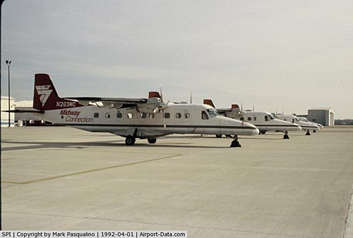 |
(Click on the photo to enlarge) |
Location
& QuickFacts
|
FAA
Information Effective: |
2007-07-05 |
|
Airport
Identifier: |
SPI |
|
Airport
Status: |
Operational |
|
Longitude/Latitude: |
089-40-40.3960W/39-50-38.7610N
-89.677888/39.844100 (Estimated) |
|
Elevation: |
597 ft / 181.97 m (Surveyed) |
|
Land: |
2300 acres |
|
From
nearest city: |
3 nautical miles NW of Springfield, IL |
|
Location: |
Sangamon County, IL |
|
Magnetic Variation: |
01W (2005) |
Owner
& Manager
|
Ownership: |
Publicly
owned |
|
Owner: |
Springfield Arpt Auth |
|
Address: |
1200 Capital Airport Dr
Springfield, IL 62707-8413 |
|
Phone number: |
217-788-1060 |
|
Manager: |
Mark Hanna |
|
Address: |
Capital Airport
Springfield, IL 62707-8419 |
|
Phone number: |
217-788-1060 |
Airport
Operations and Facilities
|
Airport
Use: |
Open
to public |
|
Wind
indicator: |
Yes |
|
Segmented Circle: |
No |
|
Control
Tower: |
Yes |
|
Lighting
Schedule: |
DUSK-DAWN
WHEN ATCT CLSD ACTVT MIRL RY 13/31; HIRL RY 04/22; MALSR
RYS 04; 22 & 31; REIL RY 13 - CTAF. VASI
RYS 04, 22, 31 & PAPI RY 13 OPER CONTINUOUSLY. |
|
Beacon
Color: |
Clear-Green (lighted land airport) |
|
Landing
fee charge: |
No |
|
Sectional chart: |
St Louis |
|
Region: |
AGL - Great Lakes |
|
Boundary
ARTCC: |
ZKC - Kansas City |
|
Tie-in
FSS: |
STL - Saint Louis |
|
FSS
on Airport: |
No |
|
FSS
Phone: |
636-536-2980 |
|
FSS
Toll Free: |
1-800-WX-BRIEF |
|
NOTAMs
Facility: |
SPI (NOTAM-d service avaliable) |
|
Certification type/date: |
I A S 05/1973 |
|
Federal Agreements: |
NGY3 |
Airport Communications
|
CTAF: |
121.300 |
|
Unicom: |
122.950 |
Airport Services
|
Fuel
available: |
100LLA
J8 FUEL AVBL. |
|
Airframe
Repair: |
MAJOR |
|
Power
Plant Repair: |
MAJOR |
|
Bottled
Oxygen: |
NONE |
|
Bulk
Oxygen: |
HIGH/LOW |
|
Runway Information
Runway 04/22
|
Dimension: |
7999 x 150 ft / 2438.1 x 45.7 m
1000 FT OVRN NW END. |
|
Surface: |
CONC, Fair Condition
400 FT CONCRETE NORTH END. |
|
Surface
Treatment: |
Saw-cut or plastic Grooved |
|
Weight
Limit: |
Single wheel: 100000 lbs.
Dual wheel: 200000 lbs.
Dual tandem wheel: 350000 lbs. |
|
Edge
Lights: |
High |
|
|
Runway 04 |
Runway 22 |
|
Longitude: |
089-41-11.1662W |
089-40-03.0462W |
|
Latitude: |
39-50-12.8413N |
39-51-11.9300N |
|
Elevation: |
587.00 ft |
597.00 ft |
|
Alignment: |
42 |
127 |
|
ILS
Type: |
ILS |
ILS |
|
Traffic
Pattern: |
Left |
Left |
|
Markings: |
Precision instrument, Good Condition |
Precision instrument, Fair Condition |
|
Arresting: |
BAK12 |
BAK12 |
|
Crossing
Height: |
56.00 ft |
54.00 ft |
|
VASI: |
4-box on left side |
4-box on left side |
|
Visual
Glide Angle: |
3.00° |
3.00° |
|
RVR
Equipment: |
touchdown |
|
|
Approach
lights: |
MALSR |
MALSR |
|
Runway
End Identifier: |
No |
No |
|
Centerline
Lights: |
No |
No |
|
Touchdown
Lights: |
No |
No |
|
Runway 13/31
|
Dimension: |
7000 x 150 ft / 2133.6 x 45.7 m
1000 FT OVRN NW END. |
|
Surface: |
ASPH, Fair Condition
400 FT CONCRETE NORTH END. |
|
Surface
Treatment: |
Saw-cut or plastic Grooved |
|
Weight
Limit: |
Single wheel: 70000 lbs.
Dual wheel: 90000 lbs.
Dual tandem wheel: 160000 lbs. |
|
Edge
Lights: |
Medium |
|
|
Runway 13 |
Runway 31 |
|
Longitude: |
089-41-15.3250W |
089-40-03.2770W |
|
Latitude: |
39-50-58.1380N |
39-50-16.8925N |
|
Elevation: |
589.00 ft |
583.00 ft |
|
Alignment: |
127 |
127 |
|
ILS
Type: |
|
ILS |
|
Traffic
Pattern: |
Left |
Left |
|
Markings: |
Non-precision instrument, Good Condition |
Precision instrument, Fair Condition |
|
Arresting: |
BAK12 |
|
|
Crossing
Height: |
36.00 ft |
54.00 ft |
|
Displaced
threshold: |
600.00 ft |
0.00 ft |
|
VASI: |
4-light PAPI on left side |
4-box on left side |
|
Visual
Glide Angle: |
3.00° |
3.00° |
|
Approach
lights: |
|
MALSR |
|
Runway
End Identifier: |
Yes |
|
|
Centerline
Lights: |
No |
No |
|
Touchdown
Lights: |
No |
No |
|
Obstruction: |
74 ft trees, 3131.0 ft from runway, 383 ft
right of centerline, 39:1 slope to clear |
, 50:1 slope to clear |
|
Runway 18/36
|
Dimension: |
5300 x 150 ft / 1615.4 x 45.7 m
1000 FT OVRN NW END. |
|
Surface: |
ASPH-CONC, Fair Condition
400 FT CONCRETE NORTH END. |
|
Weight
Limit: |
Single wheel: 60000 lbs.
Dual wheel: 70000 lbs.
Dual tandem wheel: 130000 lbs. |
|
Edge
Lights: |
Medium |
|
|
Runway 18 |
Runway 36 |
|
Longitude: |
089-40-46.0665W |
089-40-47.5480W |
|
Latitude: |
39-51-01.1197N |
39-50-08.7548N |
|
Elevation: |
590.00 ft |
587.00 ft |
|
Alignment: |
127 |
1 |
|
Traffic
Pattern: |
Left |
Left |
|
Markings: |
Basic, Fair Condition |
Basic, Fair Condition |
|
Runway
End Identifier: |
No |
No |
|
Centerline
Lights: |
No |
No |
|
Touchdown
Lights: |
No |
No |
|
Obstruction: |
88 ft tree, 2046.0 ft from runway, 292 ft left
of centerline, 20:1 slope to clear |
57 ft tree, 1547.0 ft from runway, 280 ft left
of centerline, 23:1 slope to clear |
|
Radio Navigation
Aids
|
ID |
Type |
Name |
Ch |
Freq |
Var |
Dist |
|
LQ |
NDB |
Licol |
|
375.00 |
01W |
5.3 nm |
|
SP |
NDB |
Huskk |
|
382.00 |
01W |
5.7 nm |
|
AAA |
NDB |
Abraham |
|
329.00 |
00E |
24.6 nm |
|
TAZ |
NDB |
Taylorville |
|
395.00 |
00E |
24.7 nm |
|
LTD |
NDB |
Litchfield |
|
371.00 |
01E |
40.8 nm |
|
PI |
NDB |
Tungg |
|
356.00 |
01E |
45.9 nm |
|
SYZ |
NDB |
Shelbyville |
|
365.00 |
01E |
46.7 nm |
|
CTK |
NDB |
Canton |
|
236.00 |
02E |
47.1 nm |
|
IJX |
VOR/DME |
Jacksonville |
023X |
108.60 |
02E |
26.2 nm |
|
SPI |
VORTAC |
Spinner |
74X |
112.70 |
01W |
0.3 nm |
|
CAP |
VORTAC |
Capital |
074X |
112.70 |
04E |
3.8 nm |
|
DEC |
VORTAC |
Decatur |
119X |
117.20 |
03E |
38.5 nm |
Remarks
- 1000'OVRN
SW END RWY 22.
- GENERAL
AVIATION ACCESS TO & PARKING ON THE ACR RAMP IS PROHIBITED.
- BE
ALERT; A 10 FT LGTD BARRICADE SEPERATES THE ACR & THE SOUTH GENERAL
AVIATION RAMP.
- BIRD
HAZARD-EXPECT INCR BIRD ACTIVITY (PHASE II) FR APR-JUN & AUG-OCT.
- COMBAT
WX FLT OBSERVERS ON DUTY DUR NORMAL WING FLYING HRS OR FORECASTED SEVERE
WEATHER COND EXCLUDING WIND AND MODERATE FREEZING CONDITIONS DSN 576-5905,
C 618-256-5905
- WX
SVC AVBL H24.
- DURING
COMBAT WX FLT HRS OF CLOSURE REMOTE BRIDFING AVBL FR 15 OPR WX SQUARDON
DSN 576-9755, C 618-256-9577.
- ARFF
INDEX C EQUIP AVBL UPON REQUEST; CALL 217-788-1080.
- TWY
'Y' NOT AVBL FOR ACR OPNS WITH MORE THAN 30 PSGR SEATS.
Based
Aircraft
|
Aircraft
based on field: |
189 |
|
Single
Engine Airplanes: |
133 |
|
Multi
Engine Airplanes: |
29 |
|
Jet
Engine Airplanes: |
6 |
|
Helicopters: |
4 |
|
Military: |
17 |
Major Carriers
Serving This Airport
|
Skywest Airlines Inc. |
100.0% |
Most Popular Destinations
|
Chicago
O'hare Intl (ORD) |
100.0% |
Most Popular Aircraft
|
N970SW |
2.9% |
|
N953SW |
2.6% |
|
N952SW |
2.6% |
|
N938SW |
2.4% |
|
N934SW |
2.4% |
|
N939SW |
2.2% |
|
N930SW |
2.2% |
|
N907SW |
2.2% |
|
N986SW |
2.2% |
|
N976SW |
2.2% |
Operational Statistics
Time Period: 2005-01-01
- 2005-12-31
|
Aircraft
Operations: |
142/Day |
|
Commerical: |
0.1% |
|
Air
Taxi: |
16.5% |
|
General
Aviation Local: |
29.0% |
|
General
Aviation Itinerant: |
49.2% |
|
Military: |
5.2% |
Abraham Lincoln Capital Airport
Address:
Sangamon County, IL
Tel:
217-788-1060
Images
and information placed above are from
http://www.airport-data.com/airport/SPI/
We
thank them for the data!
| General
Info |
| Country |
United
States |
| State |
ILLINOIS
|
| ICAO ID |
KSPI |
| FAA ID |
SPI |
| Time |
UTC-6(-5DT)
|
| Latitude |
39.844100
39° 50' 38.76" N |
| Longitude |
-89.677889
089° 40' 40.40" W |
| Elevation |
597 feet
182 meters |
| Type |
Civil
|
| Magnetic
Variation |
001° W
(01/06) |
| Beacon |
Yes |
| Operating
Agency |
U.S.CIVIL
AIRPORT WHEREIN PERMIT COVERS USE BY TRANSIT MILITARY AIRCRAFT |
| Near City |
Springfield
|
| Daylight
Saving Time |
Second
Sunday in March at 0200 to first Sunday in November at 0200 local
time (Exception Arizona and that portion of Indiana in the Eastern
Time Zone) |
We don't guarantee the information is fresh and accurate. The data may
be wrong or outdated.
For more up-to-date information please refer to other sources.
|
|


