 |
|
|
|
|
|
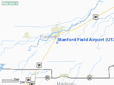
Location
& QuickFacts
|
FAA
Information Effective: |
2007-07-05 |
|
Airport
Identifier: |
U12 |
|
Airport
Status: |
Operational |
|
Longitude/Latitude: |
111-41-02.8630W/43-56-44.6820N
-111.684129/43.945745 (Estimated) |
|
Elevation: |
4966 ft / 1513.64 m (Surveyed) |
|
Land: |
90 acres |
|
From
nearest city: |
1 nautical miles SE of St Anthony, ID |
|
Location: |
Fremont County, ID |
|
Magnetic
Variation: |
16E (1985) |
Owner
& Manager
|
Ownership: |
Publicly
owned |
|
Owner: |
City Of St. Anthony |
|
Address: |
110 W Main St
St Anthony, ID 83445 |
|
Phone
number: |
208-624-3494 |
|
Manager: |
Sam Buckley |
|
Address: |
Po Box 366
St. Anthony, ID 83445 |
|
Phone
number: |
208-624-3631 |
Airport
Operations and Facilities
|
Airport
Use: |
Open
to public |
|
Wind
indicator: |
Yes |
|
Segmented Circle: |
Yes |
|
Control
Tower: |
No |
|
Lighting
Schedule: |
DUSK-DAWN |
|
Beacon
Color: |
Clear-Green (lighted land airport) |
|
Landing
fee charge: |
No |
|
Sectional chart: |
Salt Lake City |
|
Region: |
ANM - Northwest Mountain |
|
Traffic
Pattern Alt: |
800 ft |
|
Boundary
ARTCC: |
ZLC - Salt Lake City |
|
Tie-in
FSS: |
BOI - Boise |
|
FSS
on Airport: |
No |
|
FSS
Phone: |
208-332-0200 |
|
FSS
Toll Free: |
1-800-WX-BRIEF |
|
NOTAMs
Facility: |
BOI (NOTAM-d service avaliable) |
Airport
Communications
Airport
Services
|
Airframe
Repair: |
MAJOR
FOR AIRFRAME & POWER PLANT REPAIRS CALL AMGR 208-624-3631. |
|
Power
Plant Repair: |
MAJOR |
|
Bottled
Oxygen: |
NONE |
|
Bulk
Oxygen: |
NONE |
|
Runway Information
Runway 04/22
|
Dimension: |
4500
x 50 ft / 1371.6 x 15.2 m |
|
Surface: |
ASPH, Fair Condition |
|
Edge
Lights: |
Medium |
|
|
Runway 04 |
Runway 22 |
|
Traffic
Pattern: |
Left |
Left |
|
Markings: |
Nonstandard, Fair Condition
RWY 04 RY 04/22 NO DSPLCD THLD ARROW MARKINGS ON DSPLCD THLD. |
Nonstandard, Fair Condition |
|
Displaced
threshold: |
300.00 ft
/22 DSPLCD THRS MKD BY DSPLCD THR LGTS ONLY. |
540.00 ft |
|
Runway
End Identifier: |
No |
No |
|
Centerline
Lights: |
No |
No |
|
Touchdown
Lights: |
No |
No |
|
Obstruction: |
70 ft pline, 1500.0 ft from runway, 18:1 slope
to clear
25:1 TO DSPLCD THR.
+5 FT FENCE AT 0 FT; 50 FT L. |
40 ft tree, 300.0 ft from runway, 40 ft left
of centerline, 2:1 slope to clear
21:1 TO DSPLCD THLD.
NMRS CLOSE-IN OBSTS LCTD IN PRIM SFC. |
|
Radio Navigation
Aids
|
ID |
Type |
Name |
Ch |
Freq |
Var |
Dist |
|
JAC |
FAN MARKER |
Teton |
|
|
17E |
46.5 nm |
|
SWU |
NDB |
Sweden |
|
350.00 |
15E |
37.2 nm |
|
LO |
NDB |
Targy |
|
415.00 |
16E |
43.3 nm |
|
IDA |
VOR/DME |
Idaho Falls |
85Y |
113.85 |
15E |
30.5 nm |
|
JAC |
VOR/DME |
Jackson |
101X |
115.40 |
13E |
45.7 nm |
|
DBS |
VORTAC |
Dubois |
116X |
116.90 |
15E |
24.3 nm |
Remarks
- CTN:
ACFT OPER FROM GRAVEL RWY SE OF PAVED RWY DURING AGRI SEASON.
- ESTABD
PRIOR TO 15 MAY 1959.
Based
Aircraft
|
Aircraft
based on field: |
18 |
|
Single
Engine Airplanes: |
12 |
|
Helicopters: |
1 |
|
Ultralights: |
5 |
Operational Statistics
Time Period: 2005-05-27
- 2006-05-26
|
Aircraft
Operations: |
56/Week |
|
Air
Taxi: |
3.1% |
|
General
Aviation Local: |
19.0% |
|
General
Aviation Itinerant: |
77.9% |
Stanford Field Airport
Address:
Fremont County, ID
Tel:
208-624-3494,
208-624-3631
Images
and information placed above are from
http://www.airport-data.com/airport/U12/
We
thank them for the data!
| General
Info |
| Country |
United
States |
| State |
IDAHO
|
| FAA ID |
U12 |
| Latitude |
43-56-44.682N
|
| Longitude |
111-41-02.863W
|
| Elevation |
4966 feet
|
| Near City |
ST ANTHONY
|
We don't guarantee the information is fresh and accurate. The data may
be wrong or outdated.
For more up-to-date information please refer to other sources.
|
|


