 |
|
Sandpoint Airport
Dave Wall Field |
| IATA: none â ICAO: KSZT â FAA LID: SZT |
| Summary |
| Airport type |
Public |
| Owner |
Bonner County |
| Serves |
Sandpoint, Idaho |
| Elevation AMSL |
2,131 ft / 650 m |
| Coordinates |
48°17â²58â³N 116°33â²36â³W / 48.29944°N 116.56°W / 48.29944; -116.56 |
| Runways |
| Direction |
Length |
Surface |
| ft |
m |
| 1/19 |
5,501 |
1,677 |
Asphalt |
| Statistics (2006) |
| Aircraft operations |
29,900 |
| Based aircraft |
85 |
| Source: Federal Aviation Administration |
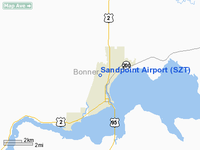
Sandpoint Airport (ICAO: KSZT, FAA LID: SZT) is a county-owned public-use airport located two nautical miles (4 km) north of the central business district of Sandpoint, in Bonner County, Idaho, United States. The airport is also known as Dave Wall Field.
Although most U.S. airports use the same three-letter location identifier for the FAA and IATA, this airport is assigned SZT by the FAA but has no designation from the IATA (which assigned SZT to San Cristóbal de las Casas National Airport in Mexico).
Facilities and aircraft
Sandpoint Airport covers an area of 104 acres (42 ha) at an elevation of 2,131 feet (650 m) above mean sea level. It has one asphalt paved runway designated 1/19 which measures 5,501 by 75 feet (1,677 x 23 m).
For the 12-month period ending April 28, 2006, the airport had 29,900 aircraft operations, an average of 81 per day: 99% general aviation and 1% air taxi. At that time there were 85 aircraft based at this airport: 84% single-engine, 13% multi-engine, 2% helicopter and 1% jet.
The above content comes from Wikipedia and is published under free licenses – click here to read more.
Location
& QuickFacts
|
FAA
Information Effective: |
2007-07-05 |
|
Airport
Identifier: |
SZT |
|
Airport
Status: |
Operational |
|
Longitude/Latitude: |
116-33-36.4860W/48-17-58.3620N
-116.560135/48.299545 (Estimated) |
|
Elevation: |
2131 ft / 649.53 m (Estimated) |
|
Land: |
104 acres |
|
From
nearest city: |
2 nautical miles N of Sandpoint, ID |
|
Location: |
Bonner County, ID |
|
Magnetic
Variation: |
18E (1995) |
Owner
& Manager
|
Ownership: |
Publicly
owned |
|
Owner: |
Bonner County |
|
Address: |
215 South First Avenue
Sandpoint, ID 83864 |
|
Phone
number: |
208-265-1438 |
|
Manager: |
Jorge Oleary |
|
Address: |
1100 Airport Way
Sandpoint, ID 83864 |
|
Phone
number: |
208-263-9102 |
Airport
Operations and Facilities
|
Airport
Use: |
Open
to public |
|
Wind
indicator: |
Yes |
|
Segmented Circle: |
Yes |
|
Control
Tower: |
No |
|
Lighting
Schedule: |
DUSK-DAWN
ACTVT MIRL RY 01/19 AND PAPI & REIL RYS 01 & 19
- CTAF. |
|
Beacon
Color: |
Clear-Green (lighted land airport) |
|
Landing
fee charge: |
No |
|
Sectional chart: |
Great Falls |
|
Region: |
ANM - Northwest Mountain |
|
Boundary
ARTCC: |
ZSE - Seattle |
|
Tie-in
FSS: |
BOI - Boise |
|
FSS
on Airport: |
No |
|
FSS
Phone: |
208-332-0200 |
|
FSS
Toll Free: |
1-800-WX-BRIEF |
|
NOTAMs
Facility: |
SZT (NOTAM-d service avaliable) |
|
Federal
Agreements: |
NGY |
Airport
Communications
|
CTAF: |
122.700 |
|
Unicom: |
122.700
|
Airport
Services
|
Fuel
available: |
100LLA |
|
Airframe
Repair: |
MAJOR |
|
Power
Plant Repair: |
MAJOR |
|
Bottled
Oxygen: |
NONE |
|
Bulk
Oxygen: |
NONE |
|
Runway Information
Runway 01/19
|
Dimension: |
5502
x 75 ft / 1677.0 x 22.9 m |
|
Surface: |
ASPH, Good Condition |
|
Weight
Limit: |
Single wheel: 40000 lbs. |
|
Edge
Lights: |
Medium |
|
|
Runway 01 |
Runway 19 |
|
Longitude: |
116-33-58.1098W |
116-33-14.8578W |
|
Latitude: |
48-17-35.3778N |
48-18-21.3446N |
|
Elevation: |
2129.00 ft |
2130.00 ft |
|
Alignment: |
32 |
127 |
|
ILS
Type: |
LOC/DME |
|
|
Traffic
Pattern: |
Left |
Left |
|
Markings: |
Non-precision instrument, Fair Condition |
Non-precision instrument, Fair Condition |
|
Crossing
Height: |
28.00 ft |
28.00 ft |
|
VASI: |
2-light PAPI on left side |
2-light PAPI on left side |
|
Visual
Glide Angle: |
3.75° |
3.75° |
|
Runway
End Identifier: |
Yes |
Yes |
|
Obstruction: |
23 ft rr, 680.0 ft from runway, 170 ft left
of centerline, 20:1 slope to clear |
85 ft trees, 1900.0 ft from runway, 100 ft
right of centerline, 20:1 slope to clear |
|
Radio Navigation
Aids
|
ID |
Type |
Name |
Ch |
Freq |
Var |
Dist |
|
SZT |
NDB |
Sandpoe |
|
264.00 |
20E |
0.5 nm |
|
DPY |
NDB |
Deer Park |
|
216.00 |
19E |
40.1 nm |
|
ION |
NDB |
Ione |
|
379.00 |
21E |
42.0 nm |
|
LYI |
NDB |
Libby |
|
414.00 |
17E |
42.6 nm |
|
SFF |
NDB |
Felts |
|
365.00 |
19E |
47.7 nm |
|
COE |
VOR/DME |
Coeur D'alene |
025X |
108.80 |
19E |
33.3 nm |
|
SFF |
VOT |
Spokane/felts Field |
|
114.00 |
|
48.2 nm |
Remarks
- ADDNL
OBSTRUCTION +23 FT RR AT 730 FT ON CNTRLINE +65 FT PLINE AT 1800 FT
ON CENTERLINE +85 FT TREES AT 1900 FT ON CENTERLINE.
- ESTABD
PRIOR TO 15 MAY 59.
Based
Aircraft
|
Aircraft
based on field: |
76 |
|
Single
Engine Airplanes: |
65 |
|
Multi
Engine Airplanes: |
8 |
|
Jet
Engine Airplanes: |
2 |
|
Helicopters: |
1 |
Operational Statistics
Time Period: 2005-04-29
- 2006-04-28
|
Aircraft
Operations: |
82/Day |
|
Air
Taxi: |
1.3% |
|
General
Aviation Local: |
33.4% |
|
General
Aviation Itinerant: |
65.2% |
Sandpoint Airport
Address:
Bonner County, ID
Tel:
208-265-1438,
208-263-9102
Images
and information placed above are from
http://www.airport-data.com/airport/SZT/
We
thank them for the data!
| General
Info |
| Country |
United
States |
| State |
IDAHO
|
| FAA ID |
SZT |
| Latitude |
48-17-58.362N
|
| Longitude |
116-33-36.486W
|
| Elevation |
2127 feet
|
| Near City |
SANDPOINT
|
We don't guarantee the information is fresh and accurate. The data may
be wrong or outdated.
For more up-to-date information please refer to other sources.
|
|


