 |
|
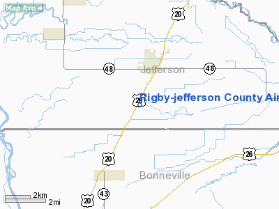
Rigby - Jefferson County Airport |
|
|
Location
& QuickFacts
|
FAA
Information Effective: |
2007-07-05 |
|
Airport
Identifier: |
U56 |
|
Airport
Status: |
Operational |
|
Longitude/Latitude: |
111-55-42.8860W/43-38-39.6830N
-111.928579/43.644356 (Estimated) |
|
Elevation: |
4845 ft / 1476.76 m (Estimated) |
|
Land: |
59 acres |
|
From
nearest city: |
2 nautical miles S of Rigby, ID |
|
Location: |
Jefferson County, ID |
|
Magnetic
Variation: |
16E (1985) |
Owner
& Manager
|
Ownership: |
Publicly
owned |
|
Owner: |
City Of Rigby & Jefferson Co |
|
Address: |
P.o. Box 275
Rigby, ID 83442
JEFFERSON COUNTY ADDRESS |
|
Phone
number: |
208-745-7756
JEFFERSON COUNTY PHONE NUMBER |
|
Manager: |
Larry Boam |
|
Address: |
34 N 3400 E
Rigby, ID 83442 |
|
Phone
number: |
208-754-4352 |
Airport
Operations and Facilities
|
Airport
Use: |
Open
to public |
|
Wind
indicator: |
Yes |
|
Segmented Circle: |
Yes |
|
Control
Tower: |
No |
|
Lighting
Schedule: |
DUSK-DAWN
ACTVT LIRL RY 01/19 - CTAF. |
|
Beacon
Color: |
Clear-Green (lighted land airport) |
|
Landing
fee charge: |
No |
|
Sectional chart: |
Salt Lake City |
|
Region: |
ANM - Northwest Mountain |
|
Boundary
ARTCC: |
ZLC - Salt Lake City |
|
Tie-in
FSS: |
BOI - Boise |
|
FSS
on Airport: |
No |
|
FSS
Phone: |
208-332-0200 |
|
FSS
Toll Free: |
1-800-WX-BRIEF |
|
NOTAMs
Facility: |
BOI (NOTAM-d service avaliable) |
|
Federal
Agreements: |
1 |
Airport
Communications
Airport
Services
|
Fuel
available: |
100LL |
|
Airframe
Repair: |
MAJOR |
|
Power
Plant Repair: |
MAJOR |
|
Bottled
Oxygen: |
NONE |
|
Bulk
Oxygen: |
NONE |
|
Runway Information
Runway 01/19
|
Dimension: |
3500
x 50 ft / 1066.8 x 15.2 m |
|
Surface: |
ASPH, |
|
Edge
Lights: |
Low |
|
|
Runway 01 |
Runway 19 |
|
Traffic
Pattern: |
Left |
Left |
|
Markings: |
Basic, Good Condition |
Basic, Good Condition |
|
Displaced
threshold: |
0.00 ft |
200.00 ft |
|
Obstruction: |
, 50:1 slope to clear
RWY 01 +4' FENCE AT 130'; 125' RIGHT, +4' FENCE AT 180', ON
CNTRLN. |
17 ft road, 500.0 ft from runway, 17:1 slope
to clear
APCH SLOPE 28:1 TO DSPLCD THR. |
|
Radio Navigation
Aids
|
ID |
Type |
Name |
Ch |
Freq |
Var |
Dist |
|
SWU |
NDB |
Sweden |
|
350.00 |
15E |
16.3 nm |
|
IDA |
VOR/DME |
Idaho Falls |
85Y |
113.85 |
15E |
9.6 nm |
|
DBS |
VORTAC |
Dubois |
116X |
116.90 |
15E |
29.4 nm |
Remarks
- (STOPWAY
LEN, RWY 19) RY 01/19 500 FT NSTD STWY N END NOT ALIGNED WITH EXTDD
RY CNTRLN IN POOR CONDITION WITH SEVERE CRACKING AND LARGE POTHOLES.
- ESTABD
PRIOR TO 15 MAY 1959.
Based
Aircraft
|
Aircraft
based on field: |
27 |
|
Single
Engine Airplanes: |
22 |
|
Multi
Engine Airplanes: |
1 |
|
Ultralights: |
4 |
Operational Statistics
Time Period: 2005-09-23
- 2006-09-22
|
Aircraft
Operations: |
193/Week |
|
General
Aviation Local: |
78.0% |
|
General
Aviation Itinerant: |
22.0% |
Rigby-jefferson County Airport
Address:
Jefferson County, ID
Tel:
208-745-7756,
208-754-4352
Images
and information placed above are from
http://www.airport-data.com/airport/U56/
We
thank them for the data!
| General
Info |
| Country |
United
States |
| State |
IDAHO
|
| FAA ID |
U56 |
| Latitude |
43-38-39.683N
|
| Longitude |
111-55-42.886W
|
| Elevation |
4845 feet
|
| Near City |
RIGBY
|
We don't guarantee the information is fresh and accurate. The data may
be wrong or outdated.
For more up-to-date information please refer to other sources.
|
|


