 |
|
|
|
|
|
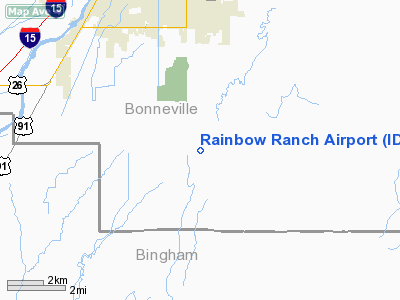
Location
& QuickFacts
|
FAA
Information Effective: |
2007-07-05 |
|
Airport
Identifier: |
ID87 |
|
Airport
Status: |
Operational |
|
Longitude/Latitude: |
111-58-27.8860W/43-24-24.6950N
-111.974413/43.406860 (Estimated) |
|
Elevation: |
4750 ft / 1447.80 m (Estimated) |
|
Land: |
0 acres |
|
From
nearest city: |
8 nautical miles SE of Idaho Falls, ID |
|
Location: |
Bonneville County, ID |
|
Magnetic
Variation: |
16E (1985) |
Owner
& Manager
|
Ownership: |
Privately
owned |
|
Owner: |
Hoff Bros Inc |
|
Address: |
10741 S 25 E
Idaho Falls, ID 83406 |
|
Phone
number: |
208-522-8567 |
|
Manager: |
Robert A Hoff |
|
Address: |
10741 S 25 E
Idaho Falls, ID 83406 |
|
Phone
number: |
208-522-8567 |
Airport
Operations and Facilities
|
Airport Use: |
Private |
|
Wind
indicator: |
Yes |
|
Segmented
Circle: |
No |
|
Control
Tower: |
No |
|
Landing
fee charge: |
No |
|
Sectional
chart: |
Salt Lake City |
|
Region: |
ANM - Northwest Mountain |
|
Boundary
ARTCC: |
ZLC - Salt Lake City |
|
Tie-in
FSS: |
BOI - Boise |
|
FSS
on Airport: |
No |
|
FSS
Phone: |
208-332-0200 |
|
FSS
Toll Free: |
1-800-WX-BRIEF |
Airport
Communications
Airport
Services
|
Fuel
available: |
100LL |
|
Airframe
Repair: |
NONE |
|
Power
Plant Repair: |
NONE |
|
Runway Information
Runway 07/25
|
Dimension: |
2400
x 120 ft / 731.5 x 36.6 m |
|
Surface: |
TURF, |
|
|
Runway 07 |
Runway 25 |
|
Traffic
Pattern: |
Left |
Right |
|
Radio Navigation
Aids
|
ID |
Type |
Name |
Ch |
Freq |
Var |
Dist |
|
SWU |
NDB |
Sweden |
|
350.00 |
15E |
8.4 nm |
|
IDA |
VOR/DME |
Idaho Falls |
85Y |
113.85 |
15E |
7.8 nm |
|
DBS |
VORTAC |
Dubois |
116X |
116.90 |
15E |
42.2 nm |
|
PIH |
VORTAC |
Pocatello |
073X |
112.60 |
17E |
43.9 nm |
Remarks
- APRT
EXISTED PRIOR TO 12/31/58.
Based
Aircraft
|
Aircraft
based on field: |
4 |
|
Single
Engine Airplanes: |
4 |
Rainbow Ranch Airport
Address:
Bonneville County, ID
Tel:
208-522-8567
Images
and information placed above are from
http://www.airport-data.com/airport/ID87/
We
thank them for the data!
| General
Info |
| Country |
United
States |
| State |
IDAHO
|
| FAA ID |
ID87 |
| Latitude |
43-24-24.695N
|
| Longitude |
111-58-27.886W
|
| Elevation |
4750 feet
|
| Near City |
IDAHO
FALLS |
We don't guarantee the information is fresh and accurate. The data may
be wrong or outdated.
For more up-to-date information please refer to other sources.
|
|


