 |
|
| Nampa Municipal Airport |
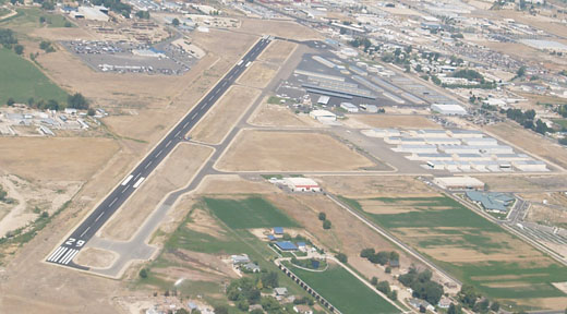 |
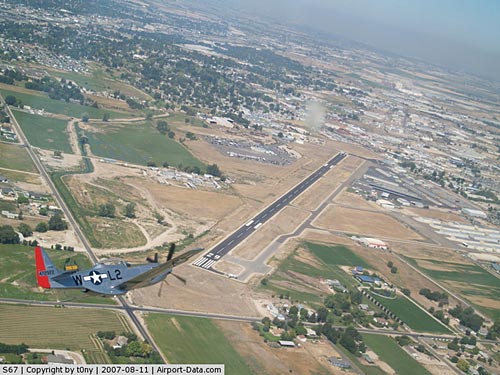
| Aerial view, 2007 |
| IATA: none â ICAO: KMAN â FAA LID: MAN |
| Summary |
| Airport type |
Public |
| Owner |
City of Nampa |
| Serves |
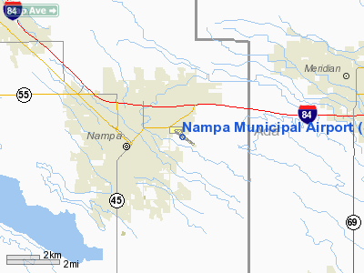
Nampa, Idaho |
| Elevation AMSL |
2,537 ft / 773 m |
| Coordinates |
43°34â²53â³N 116°31â²23â³W / 43.58139°N 116.52306°W / 43.58139; -116.52306 |
| Website |
www.NampaAirport.org |
| Runways |
| Direction |
Length |
Surface |
| ft |
m |
| 11/29 |
5,000 |
1,524 |
Asphalt |
| Statistics (2007) |
| Aircraft operations |
105,600 |
| Based aircraft |
277 |
| Sources: Airport website and FAA |
Nampa Municipal Airport (ICAO: KMAN, FAA LID: MAN, formerly S67) is a city-owned, public-use airport located in Nampa, a city in Canyon County, Idaho, United States. According to the FAA's National Plan of Integrated Airport Systems for 2009â2013, it is categorized as a general aviation airport.
It is currently used for private, emergency, military, and industrial reasons. It is also home to the Warhawk Air Museum. The airport is undergoing construction. The National Guard Base is located inside the airport's grounds. Nampa Municipal Airport is a member of Rocky Mountain Air and the Snake River Flight Training Club. Mission Aviation Fellowship is also headquartered at the Nampa Airport.
Although many U.S. airports use the same three-letter location identifier for the FAA and IATA, this airport is assigned MAN by the FAA but has no designation from the IATA (which assigned MAN to Manchester Airport in Manchester, England, United Kingdom). Facilities and aircraft
Nampa Municipal Airport covers an area of 126 acres (51 ha) at an elevation of 2,537 feet (773 m) above mean sea level. It has one asphalt paved runway designated 11/29 which measures 5,000 by 75 feet (1,524 x 23 m).
For the 12-month period ending June 20, 2007, the airport had 105,600 aircraft operations, an average of 289 per day: 98.5% general aviation and 1.5% air taxi. At that time there were 277 aircraft based at this airport: 86.6% single-engine, 2.9% multi-engine, 2.5% helicopter, 4% glider and 4% ultralight.
Services
Services are for pilots only. Some services include cheap aircraft stowing, pilot service (such as a lounge, internet access, and rentals), and transportation. The airport also offers full service during business hours.
The above content comes from Wikipedia and is published under free licenses – click here to read more.
|
 |
(Click on the photo to enlarge) |
Location
& QuickFacts
|
FAA
Information Effective: |
2007-07-05 |
|
Airport
Identifier: |
S67 |
|
Airport
Status: |
Operational |
|
Longitude/Latitude: |
116-31-23.0000W/43-34-52.8000N
-116.523056/43.581333 (Estimated) |
|
Elevation: |
2537 ft / 773.28 m (Surveyed) |
|
Land: |
126 acres |
|
From
nearest city: |
0 nautical miles E of Nampa, ID |
|
Location: |
Canyon County, ID |
|
Magnetic
Variation: |
16E (2000) |
Owner
& Manager
|
Ownership: |
Publicly
owned |
|
Owner: |
City Of Nampa |
|
Address: |
411 Third St, South
Nampa, ID 83651 |
|
Phone
number: |
208-468-5411 |
|
Manager: |
Colleen Hartnett |
|
Address: |
101 Municipal Drive
Nampa, ID 83687 |
|
Phone
number: |
208-468-5820 |
Airport
Operations and Facilities
|
Airport
Use: |
Open
to public |
|
Wind
indicator: |
Yes |
|
Segmented Circle: |
Yes |
|
Control
Tower: |
No |
|
Lighting
Schedule: |
DUSK-DAWN
ACTVT PAPI RY 11 AND 29 - CTAF. |
|
Beacon
Color: |
Clear-Green (lighted land airport) |
|
Landing
fee charge: |
No |
|
Sectional chart: |
Salt Lake City |
|
Region: |
ANM - Northwest Mountain |
|
Traffic
Pattern Alt: |
1000 ft |
|
Boundary
ARTCC: |
ZLC - Salt Lake City |
|
Tie-in
FSS: |
BOI - Boise |
|
FSS
on Airport: |
No |
|
FSS
Phone: |
208-332-0200 |
|
FSS
Toll Free: |
1-800-WX-BRIEF |
|
NOTAMs
Facility: |
BOI (NOTAM-d service avaliable) |
|
Federal
Agreements: |
NGY |
Airport
Communications
|
CTAF: |
122.700 |
|
Unicom: |
122.700
|
Airport
Services
|
Fuel
available: |
100LLA |
|
Airframe
Repair: |
MAJOR |
|
Power
Plant Repair: |
MAJOR |
|
Bottled
Oxygen: |
LOW |
|
Bulk
Oxygen: |
NONE |
|
Runway Information
Runway 11/29
|
Dimension: |
5000
x 75 ft / 1524.0 x 22.9 m |
|
Surface: |
ASPH, Good Condition |
|
Weight
Limit: |
Single wheel: 12500 lbs. |
|
Edge
Lights: |
Medium |
|
|
Runway 11 |
Runway 29 |
|
Longitude: |
116-31-50.6221W |
116-30-55.4348W |
|
Latitude: |
43-35-07.2172N |
43-34-38.4379N |
|
Elevation: |
2537.00 ft |
2530.00 ft |
|
Alignment: |
126 |
127 |
|
Traffic
Pattern: |
Left |
Left |
|
Markings: |
Non-precision instrument, Fair Condition |
Non-precision instrument, Fair Condition |
|
Crossing
Height: |
40.00 ft |
45.00 ft |
|
VASI: |
2-light PAPI on left side |
2-light PAPI on left side |
|
Visual
Glide Angle: |
3.00° |
3.62° |
|
Obstruction: |
100 ft bldg, 2790.0 ft from runway, 700 ft
right of centerline, 25:1 slope to clear |
50 ft trees, 960.0 ft from runway, 150 ft left
of centerline, 15:1 slope to clear |
|
Radio Navigation
Aids
|
ID |
Type |
Name |
Ch |
Freq |
Var |
Dist |
|
MPA |
NDB |
Meridian |
|
238.00 |
16E |
1.5 nm |
|
BO |
NDB |
Ustik |
|
359.00 |
17E |
9.1 nm |
|
ONO |
NDB |
Ontario |
|
305.00 |
17E |
33.7 nm |
|
STI |
NDB |
Sturgeon |
|
333.00 |
17E |
47.1 nm |
|
MUO |
TACAN |
Mountain Home |
087X |
|
18E |
43.1 nm |
|
LIA |
VOR |
Liberator |
|
114.90 |
18E |
48.7 nm |
|
BOI |
VORTAC |
Boise |
080X |
113.30 |
17E |
14.5 nm |
|
BOI |
VOT |
Boise |
|
116.70 |
|
12.8 nm |
Remarks
- REFLECTORS
ON PARALLEL TAXIWAY.
- ESTABD
PRIOR TO 15 MAY 1959.
Based
Aircraft
|
Aircraft
based on field: |
272 |
|
Single
Engine Airplanes: |
226 |
|
Multi
Engine Airplanes: |
7 |
|
Helicopters: |
16 |
|
Gliders: |
6 |
|
Ultralights: |
17 |
Operational Statistics
Time Period: 2003-02-28
- 2004-02-27
|
Aircraft
Operations: |
290/Day |
|
Air
Taxi: |
1.5% |
|
General
Aviation Local: |
47.3% |
|
General
Aviation Itinerant: |
51.1% |
|
Military: |
0.1% |
Nampa Municipal Airport
Address:
Canyon County, ID
Tel:
208-468-5411,
208-468-5820
Images
and information placed above are from
http://www.airport-data.com/airport/S67/
We
thank them for the data!
| General
Info |
| Country |
United
States |
| State |
IDAHO
|
| FAA ID |
S67 |
| Latitude |
43-34-52.800N
|
| Longitude |
116-31-23.000W
|
| Elevation |
2537 feet
|
| Near City |
NAMPA
|
We don't guarantee the information is fresh and accurate. The data may
be wrong or outdated.
For more up-to-date information please refer to other sources.
|
|


