 |
|
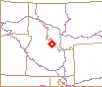
| Lemhi County Airport |
 |
| IATA: SMN â ICAO: KSMN â FAA LID: SMN |
| Summary |
| Airport type |
Public |
| Operator |
Lemhi County |
| Location |
Salmon, Idaho |
| Elevation AMSL |
4,043 ft / 1,232.3 m |
| Coordinates |
45°07â²26â³N 113°52â²53â³W / 45.12389°N 113.88139°W / 45.12389; -113.88139Coordinates: 45°07â²26â³N 113°52â²53â³W / 45.12389°N 113.88139°W / 45.12389; -113.88139 |
| Runways |
| Direction |
Length |
Surface |
| ft |
m |
| 17/35 |
5,150 |
1,570 |
Asphalt |
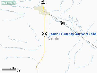
Lemhi County Airport (IATA: SMN, ICAO: KSMN, FAA LID: SMN) is a public airport located four miles (6 km) south of the central business district (CBD) of Salmon, a city in Lemhi County, Idaho, USA. The airport covers 259 acres (105 ha) and has one runway.
Airlines
| Airlines |
Destinations |
| Salmon Air |
Boise, McCall |
The above content comes from Wikipedia and is published under free licenses – click here to read more.
Location
& QuickFacts
|
FAA
Information Effective: |
2007-07-05 |
|
Airport
Identifier: |
SMN |
|
Airport
Status: |
Operational |
|
Longitude/Latitude: |
113-52-52.7950W/45-07-25.6100N
-113.881332/45.123781 (Estimated) |
|
Elevation: |
4043 ft / 1232.31 m (Surveyed) |
|
Land: |
259 acres |
|
From
nearest city: |
4 nautical miles S of Salmon, ID |
|
Location: |
Lemhi County, ID |
|
Magnetic Variation: |
16E (2000) |
Owner
& Manager
|
Ownership: |
Publicly
owned |
|
Owner: |
Lemhi Co |
|
Address: |
206 Courthouse Drive
Salmon, ID 83467 |
|
Phone
number: |
208-756-2815 |
|
Manager: |
Tom Conrad |
|
Address: |
P O Box 62
Carmen, ID 83462 |
|
Phone number: |
208-756-2255 |
Airport Operations and Facilities
|
Airport
Use: |
Open
to public |
|
Wind
indicator: |
Yes |
|
Segmented Circle: |
Yes |
|
Control
Tower: |
No |
|
Lighting
Schedule: |
DUSK-DAWN
BEACON OTS INDEFLY. |
|
Beacon
Color: |
Clear-Green (lighted land airport) |
|
Landing
fee charge: |
No |
|
Sectional chart: |
Great Falls |
|
Region: |
ANM - Northwest Mountain |
|
Boundary
ARTCC: |
ZLC - Salt Lake City |
|
Tie-in
FSS: |
BOI - Boise |
|
FSS
on Airport: |
No |
|
FSS
Phone: |
208-332-0200 |
|
FSS
Toll Free: |
1-800-WX-BRIEF |
|
NOTAMs
Facility: |
SMN (NOTAM-d service avaliable) |
|
Federal Agreements: |
NGY |
Airport Communications
|
CTAF: |
122.800 |
|
Unicom: |
122.800
|
Airport
Services
|
Fuel
available: |
100
A |
|
Airframe
Repair: |
MAJOR |
|
Power
Plant Repair: |
MAJOR |
|
Bottled
Oxygen: |
NONE |
|
Bulk
Oxygen: |
NONE |
|
Runway Information
Runway 17/35
|
Dimension: |
5150
x 60 ft / 1569.7 x 18.3 m |
|
Surface: |
ASPH, Good Condition |
|
Weight
Limit: |
Single wheel: 12500 lbs. |
|
Edge
Lights: |
Medium |
|
|
Runway 17 |
Runway 35 |
|
Longitude: |
113-52-47.9250W |
113-52-57.6600W |
|
Latitude: |
45-07-50.7870N |
45-07-00.4320N |
|
Elevation: |
4036.00 ft |
4043.00 ft |
|
Alignment: |
127 |
8 |
|
Traffic
Pattern: |
Left |
Left |
|
Markings: |
Basic, Good Condition |
Basic, Good Condition |
|
Crossing
Height: |
55.00 ft |
0.00 ft |
|
VASI: |
4-light PAPI on left side |
|
|
Visual
Glide Angle: |
3.50° |
0.00° |
|
Runway
End Identifier: |
Yes |
|
|
Obstruction: |
4 ft fence, 280.0 ft from runway, 20:1 slope
to clear |
30 ft tree, 1300.0 ft from runway, 50 ft left
of centerline, 36:1 slope to clear |
|
Radio Navigation
Aids
|
ID |
Type |
Name |
Ch |
Freq |
Var |
Dist |
|
LLJ |
NDB |
Challis |
|
397.00 |
17E |
39.0 nm |
|
LKT |
VOR/DME |
Salmon |
082X |
113.50 |
18E |
10.6 nm |
Remarks
- RETROREFLECTIVE
REFLECTORS ON PARALLEL TWY AND RAMP AREA.
- TAXIWAY
ACCESS TO AIRCRAFT RAMP LOCATED ON SE END OF AIRPORT IS CLSD.
- RY
17/35 N 500 FT SHARP DROP-OFF ON W SHOULDER.
- CONSTD
PRIOR TO 1959.
Based
Aircraft
|
Aircraft
based on field: |
53 |
|
Single
Engine Airplanes: |
44 |
|
Multi
Engine Airplanes: |
8 |
|
Helicopters: |
1 |
Operational Statistics
Time Period: 2005-05-24
- 2006-05-23
|
Aircraft
Operations: |
68/Day |
|
Air
Taxi: |
36.7% |
|
General
Aviation Local: |
30.6% |
|
General
Aviation Itinerant: |
32.7% |
Landmark U S Forest Service Airport
Address:
Lemhi County, ID
Tel:
208-756-2815,
208-756-2255
Images
and information placed above are from
http://www.airport-data.com/airport/SMN/
We
thank them for the data!
| General
Info |
| Country |
United
States |
| State |
IDAHO
|
| FAA ID |
SMN |
| Latitude |
45-07-25.610N
|
| Longitude |
113-52-52.795W
|
| Elevation |
4043 feet
|
| Near City |
SALMON
|
We don't guarantee the information is fresh and accurate. The data may
be wrong or outdated.
For more up-to-date information please refer to other sources.
|
|


