 |
|
Lee Williams Memorial Airport |
|
|
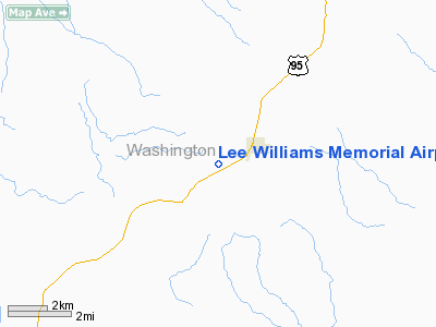
Location
& QuickFacts
|
FAA
Information Effective: |
2007-07-05 |
|
Airport
Identifier: |
0U9 |
|
Airport
Status: |
Operational |
|
Longitude/Latitude: |
116-45-27.5880W/44-27-41.5850N
-116.757663/44.461551 (Estimated) |
|
Elevation: |
2617 ft / 797.66 m (Surveyed) |
|
Land: |
15 acres |
|
From
nearest city: |
1 nautical miles SW of Midvale, ID |
|
Location: |
Washington County, ID |
|
Magnetic Variation: |
18E (1985) |
Owner
& Manager
|
Ownership: |
Publicly
owned |
|
Owner: |
City Of Midvale |
|
Address: |
P O Box 115
Midvale, ID 83645 |
|
Phone number: |
208-355-2221 |
|
Manager: |
David Craig |
|
Address: |
Rt 1 Box 10
Midvale, ID 83645 |
|
Phone number: |
208-355-2391 |
Airport
Operations and Facilities
|
Airport
Use: |
Open
to public |
|
Wind
indicator: |
Yes |
|
Segmented Circle: |
No |
|
Control
Tower: |
No |
|
Landing
fee charge: |
No |
|
Sectional chart: |
Salt Lake City |
|
Region: |
ANM - Northwest Mountain |
|
Boundary
ARTCC: |
ZLC - Salt Lake City |
|
Tie-in
FSS: |
BOI - Boise |
|
FSS
on Airport: |
No |
|
FSS
Phone: |
208-332-0200 |
|
FSS
Toll Free: |
1-800-WX-BRIEF |
|
NOTAMs
Facility: |
BOI (NOTAM-d service avaliable) |
Airport Communications
Airport Services
|
Airframe
Repair: |
NONE |
|
Power
Plant Repair: |
NONE |
|
Bottled
Oxygen: |
NONE |
|
Bulk
Oxygen: |
NONE |
|
Runway Information
Runway 07/25
|
Dimension: |
2902
x 60 ft / 884.5 x 18.3 m |
|
Surface: |
ASPH, Good Condition |
|
|
Runway 07 |
Runway 25 |
|
Longitude: |
116-45-47.3700W |
116-45-07.4000W |
|
Latitude: |
44-27-41.9700N |
44-27-40.6700N |
|
Traffic
Pattern: |
Left |
Left |
|
Markings: |
Basic, Good Condition
/25 WEST HALF & 07 THLD MKD WITH WHITE PLASTIC PIPE. |
Basic, Good Condition |
|
Obstruction: |
4 ft fence, 273.0 ft from runway, 19:1 slope
to clear
+4 FT FENCE AT 35 FT ON CNTRLN. |
4 ft fence, 0.0 ft from runway, 170 ft left
of centerline |
|
Radio Navigation
Aids
|
ID |
Type |
Name |
Ch |
Freq |
Var |
Dist |
|
ONO |
NDB |
Ontario |
|
305.00 |
17E |
28.7 nm |
|
IOM |
NDB |
Mc Call |
|
363.00 |
17E |
34.8 nm |
|
DNJ |
VORTAC |
Donnelly |
109X |
116.20 |
19E |
29.9 nm |
Remarks
- NO
WINTER MAINT, ARPT CLSD WHEN SNOW CONDS DICTATE.
- NO
TELEPHONE AVBL AT ARPT.
- ESTABD
PRIOR TO 15 MAY 1959.
Based
Aircraft
|
Aircraft
based on field: |
4 |
|
Single
Engine Airplanes: |
4 |
Operational Statistics
Time Period: 2002-09-18
- 2003-09-17
|
Aircraft
Operations: |
43/Week |
|
General
Aviation Local: |
20.5% |
|
General
Aviation Itinerant: |
79.5% |
Lee Williams Memorial Airport
Address:
Washington County, ID
Tel:
208-355-2221, 208-355-2391
Images
and information placed above are from
http://www.airport-data.com/airport/0U9/
We
thank them for the data!
| General
Info |
| Country |
United
States |
| State |
IDAHO
|
| FAA ID |
0U9 |
| Latitude |
44-27-41.585N
|
| Longitude |
116-45-27.588W
|
| Elevation |
2617 feet
|
| Near City |
MIDVALE
|
We don't guarantee the information is fresh and accurate. The data may
be wrong or outdated.
For more up-to-date information please refer to other sources.
|
|


