 |
|
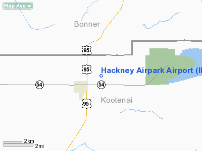
Location
& QuickFacts
|
FAA
Information Effective: |
2007-07-05 |
|
Airport
Identifier: |
ID05 |
|
Airport
Status: |
Operational |
|
Longitude/Latitude: |
116-40-38.7090W/47-57-24.6530N
-116.677419/47.956848 (Estimated) |
|
Elevation: |
2445 ft / 745.24 m (Estimated) |
|
Land: |
60 acres |
|
From
nearest city: |
2 nautical miles NE of Athol, ID |
|
Location: |
Kootenai County, ID |
|
Magnetic Variation: |
19E (1985) |
Owner & Manager
|
Ownership: |
Privately owned |
|
Owner: |
Hackney Airpark Inc. |
|
Address: |
Box 356
Athol, ID 83801 |
|
Phone number: |
208-683-8707 |
|
Manager: |
B E Stanley |
|
Address: |
Po Box 356
Athol, ID 83801 |
|
Phone number: |
208-683-3726 |
Airport Operations and Facilities
|
Airport Use: |
Private |
|
Wind indicator: |
Yes |
|
Segmented Circle: |
No |
|
Control Tower: |
No |
|
Landing fee charge: |
No |
|
Sectional chart: |
Great Falls |
|
Region: |
ANM - Northwest Mountain |
|
Boundary ARTCC: |
ZSE - Seattle |
|
Tie-in FSS: |
BOI - Boise |
|
FSS on Airport: |
No |
|
FSS Phone: |
208-332-0200 |
|
FSS Toll Free: |
1-800-WX-BRIEF |
Airport Services
|
Airframe
Repair: |
MAJOR |
|
Power
Plant Repair: |
MAJOR |
|
Runway Information
Runway 03/21
|
Dimension: |
3500
x 150 ft / 1066.8 x 45.7 m |
|
Surface: |
TURF, |
|
|
Runway 03 |
Runway 21 |
|
Traffic
Pattern: |
Left |
Left |
|
Runway
End Identifier: |
No |
No |
|
Centerline
Lights: |
No |
No |
|
Touchdown
Lights: |
No |
No |
|
Radio Navigation
Aids
|
ID |
Type |
Name |
Ch |
Freq |
Var |
Dist |
|
SZT |
NDB |
Sandpoe |
|
264.00 |
20E |
20.6 nm |
|
DPY |
NDB |
Deer Park |
|
216.00 |
19E |
30.2 nm |
|
SFF |
NDB |
Felts |
|
365.00 |
19E |
30.3 nm |
|
SKA |
TACAN |
Fairchild |
051X |
|
19E |
44.9 nm |
|
COE |
VOR/DME |
Coeur D'alene |
025X |
108.80 |
19E |
12.4 nm |
|
GEG |
VORTAC |
Spokane |
102X |
115.50 |
21E |
45.0 nm |
|
SFF |
VOT |
Spokane/felts Field |
|
114.00 |
|
30.8 nm |
|
GEG |
VOT |
Spokane Intl |
|
109.60 |
|
40.2 nm |
Remarks
- RY
POORLY DEFINED EXCP BY BARE AREAS FROM USE BY ACFT.
- NO
LINE OF SIGHT BTN RY ENDS DUE TO HUMP, USE AT OWN RISK.
Based
Aircraft
|
Aircraft
based on field: |
25 |
|
Single
Engine Airplanes: |
22 |
|
Gliders: |
1 |
|
Ultralights: |
2 |
Operational Statistics
|
Aircraft
Operations: |
77/Week |
|
General
Aviation Local: |
75.0% |
|
General
Aviation Itinerant: |
25.0% |
Hackney Airpark Airport
Address:
Kootenai County, ID
Tel:
208-683-8707, 208-683-3726
Images
and information placed above are from
http://www.airport-data.com/airport/ID05/
We
thank them for the data!
| General
Info |
| Country |
United
States |
| State |
IDAHO
|
| FAA ID |
ID05 |
| Latitude |
47-57-24.653N
|
| Longitude |
116-40-38.709W
|
| Elevation |
2445 feet
|
| Near City |
ATHOL
|
We don't guarantee the information is fresh and accurate. The data may
be wrong or outdated.
For more up-to-date information please refer to other sources.
|
|


