 |
|
Graham U.S. Forest Service Airport |
|
|
Location
& QuickFacts
|
FAA
Information Effective: |
2007-07-05 |
|
Airport
Identifier: |
U45 |
|
Airport
Status: |
Operational |
|
Longitude/Latitude: |
115-16-21.3280W/43-57-18.6420N
-115.272591/43.955178 (Estimated) |
|
Elevation: |
5726 ft / 1745.28 m (Surveyed) |
|
Land: |
11 acres |
|
From
nearest city: |
11 nautical miles NW of Atlanta, ID |
|
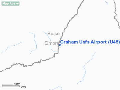
Location: |
Elmore County, ID |
|
Magnetic Variation: |
17E (1985) |
Owner
& Manager
|
Ownership: |
Publicly
owned |
|
Owner: |
U S Forest Service |
|
Address: |
324 25th St
Ogden, UT 84401 |
|
Phone
number: |
801-625-5511 |
|
Manager: |
Boise Forest Air Officer |
|
Address: |
1249 S Vinnel Way
Boise, ID 83709 |
|
Phone number: |
208-373-4176 |
Airport Operations and Facilities
|
Airport
Use: |
Open
to public |
|
Wind
indicator: |
Yes |
|
Segmented Circle: |
No |
|
Control
Tower: |
No |
|
Landing
fee charge: |
No |
|
Sectional chart: |
Salt Lake City |
|
Region: |
ANM - Northwest Mountain |
|
Boundary
ARTCC: |
ZLC - Salt Lake City |
|
Tie-in
FSS: |
BOI - Boise |
|
FSS
on Airport: |
No |
|
FSS
Phone: |
208-332-0200 |
|
FSS
Toll Free: |
1-800-WX-BRIEF |
|
NOTAMs
Facility: |
BOI (NOTAM-d service avaliable) |
Airport Communications
Airport Services
|
Airframe
Repair: |
NONE |
|
Power
Plant Repair: |
NONE |
|
Bottled
Oxygen: |
NONE |
|
Bulk
Oxygen: |
NONE |
|
Runway Information
Runway 18/36
|
Dimension: |
2900
x 50 ft / 883.9 x 15.2 m |
|
Surface: |
CONC-GRVL, Fair Condition |
|
|
Runway 18 |
Runway 36 |
|
Traffic
Pattern: |
Left |
Left |
|
Obstruction: |
30 ft trees, 55 ft left of centerline |
14 ft road, 0.0 ft from runway, 45 ft left
of centerline |
|
Radio Navigation
Aids
|
ID |
Type |
Name |
Ch |
Freq |
Var |
Dist |
|
BOI |
VORTAC |
Boise |
080X |
113.30 |
17E |
46.7 nm |
|
BOI |
VOT |
Boise |
|
116.70 |
|
47.6 nm |
Remarks
- NO
WINTER MAINTENANCE.
- RECOMMEND
LNDG RWY 36; TAKEOFF RWY 18 WHEN WIND CONDITIONS ALLOW.
- ARPT
SURROUNDED BY HIGH MOUNTAINOUS TERRAIN.
- BIG
GAME ANIMALS ON & INVOF ARPT.
- NO
TELEPHONE AVBL AT ARPT.
- RY
18/36 LOWER ONE THIRD OF RY SOFT AND UNUSUABLE DURING EARLY SPRING.
- EXISTED
PRIOR TO 31 DEC 1958.
Operational
Statistics
Time Period: 2002-01-01
- 2002-12-31
|
Aircraft
Operations: |
18/Week |
|
Air
Taxi: |
11.1% |
|
General
Aviation Itinerant: |
88.9% |
Graham U S Forest Service Airport
Address:
Elmore County, ID
Tel:
801-625-5511,
208-373-4176
Images
and information placed above are from
http://www.airport-data.com/airport/U45/
We
thank them for the data!
| General
Info |
| Country |
United
States |
| State |
IDAHO
|
| FAA ID |
U45 |
| Latitude |
43-57-18.642N
|
| Longitude |
115-16-21.328W
|
| Elevation |
5726 feet
|
| Near City |
ATLANTA
|
We don't guarantee the information is fresh and accurate. The data may
be wrong or outdated.
For more up-to-date information please refer to other sources.
|
|


