 |
|
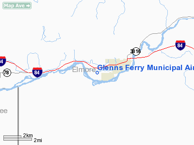
Glenns Ferry Municipal Airport |
|
|
Location
& QuickFacts
|
FAA
Information Effective: |
2007-07-05 |
|
Airport
Identifier: |
U89 |
|
Airport
Status: |
Operational |
|
Longitude/Latitude: |
115-19-48.2560W/42-56-44.6350N
-115.330071/42.945732 (Estimated) |
|
Elevation: |
2536 ft / 772.97 m (Surveyed) |
|
Land: |
85 acres |
|
From
nearest city: |
1 nautical miles SW of Glenns Ferry, ID |
|
Location: |
Elmore County, ID |
|
Magnetic Variation: |
17E (1985) |
Owner
& Manager
|
Ownership: |
Publicly
owned |
|
Owner: |
City Of Glenns Ferry |
|
Address: |
P.o. Box 910
Glenns Ferry, ID 83623 |
|
Phone
number: |
208-366-7418 |
|
Manager: |
Curly Schamber |
|
Address: |
P O Box 551
Glenns Ferry, ID 83623 |
|
Phone number: |
208-366-2281 |
Airport Operations and Facilities
|
Airport
Use: |
Open
to public |
|
Wind
indicator: |
Yes |
|
Segmented Circle: |
Yes |
|
Control
Tower: |
No |
|
Lighting
Schedule: |
RDO-CTL
ACTVT ROTG BCN AND MIRL RY 08/26 - CTAF. |
|
Beacon
Color: |
Clear-Green (lighted land airport) |
|
Landing
fee charge: |
No |
|
Sectional chart: |
Salt Lake City |
|
Region: |
ANM - Northwest Mountain |
|
Boundary
ARTCC: |
ZLC - Salt Lake City |
|
Tie-in
FSS: |
BOI - Boise |
|
FSS
on Airport: |
No |
|
FSS
Phone: |
208-332-0200 |
|
FSS
Toll Free: |
1-800-WX-BRIEF |
|
NOTAMs
Facility: |
BOI (NOTAM-d service avaliable) |
|
Federal Agreements: |
1 |
Airport Communications
Airport Services
|
Airframe
Repair: |
NONE |
|
Power
Plant Repair: |
NONE |
|
Bottled
Oxygen: |
NONE |
|
Bulk
Oxygen: |
NONE |
|
Runway Information
Runway 08/26
|
Dimension: |
3050
x 60 ft / 929.6 x 18.3 m |
|
Surface: |
ASPH, Good Condition |
|
Edge
Lights: |
Medium |
|
|
Runway 08 |
Runway 26 |
|
Traffic
Pattern: |
Left |
Left |
|
Markings: |
Basic, Good Condition |
Basic, Good Condition |
|
Obstruction: |
, 50:1 slope to clear
+4' FENCE AT 95' ON CNTRLN. |
90 ft trees, 2000.0 ft from runway, 20:1 slope
to clear
+4 FT FENCE AT 65 FT ON CNTRLN; +15 FT ROAD AT 85 FT ON CNTRLN. |
|
Radio Navigation
Aids
|
ID |
Type |
Name |
Ch |
Freq |
Var |
Dist |
|
STI |
NDB |
Sturgeon |
|
333.00 |
17E |
17.6 nm |
|
HDG |
NDB |
Steelhead |
|
211.00 |
16E |
28.9 nm |
|
MUO |
TACAN |
Mountain Home |
087X |
|
18E |
24.6 nm |
|
LIA |
VOR |
Liberator |
|
114.90 |
18E |
19.7 nm |
|
TWF |
VORTAC |
Twin Falls |
105X |
115.80 |
18E |
46.5 nm |
Remarks
- RWY
08 +150' PLINE CROSSES SNAKE RIVER CANYON APPROX 5 MILES DOWNRIVER.
- RY
08/26 DISTANCE TO GO MARKERS EVERY 1000 FT S SIDE OF RY.
- BUILT
PRIOR TO 1959.
Based
Aircraft
|
Aircraft
based on field: |
4 |
|
Single
Engine Airplanes: |
4 |
Operational Statistics
Time Period: 2005-01-25
- 2006-01-24
|
Aircraft
Operations: |
34/Month |
|
General
Aviation Local: |
50.0% |
|
General
Aviation Itinerant: |
50.0% |
Glenns Ferry Municipal Airport
Address:
Elmore County, ID
Tel:
208-366-7418,
208-366-2281
Images
and information placed above are from
http://www.airport-data.com/airport/U89/
We
thank them for the data!
| General
Info |
| Country |
United
States |
| State |
IDAHO
|
| FAA ID |
U89 |
| Latitude |
42-56-44.635N
|
| Longitude |
115-19-48.256W
|
| Elevation |
2536 feet
|
| Near City |
GLENNS
FERRY |
We don't guarantee the information is fresh and accurate. The data may
be wrong or outdated.
For more up-to-date information please refer to other sources.
|
|


