|
|
Friedman Memorial Airport |
| Friedman Memorial Airport |
| IATA: SUN â ICAO: KSUN â FAA LID: SUN |
| Summary |
| Airport type |
Public |
| Owner |
City of Hailey |
| Operator |
Friedman Memorial Airport Authority |
| Serves |
Hailey, Idaho |
| Elevation AMSL |
5,318 ft / 1,621 m |
| Coordinates |
43°30â²14â³N 114°17â²44â³W / 43.50389°N 114.29556°W / 43.50389; -114.29556 |
| Website |
www.FlyFMA.com |
| Runways |
| Direction |
Length |
Surface |
| ft |
m |
| 13/31 |
7,550 |
2,301 |
Asphalt |
| Statistics (2007) |
| Aircraft operations |
68,540 |
| Based aircraft |
150 |
| Sources: airport website and FAA |
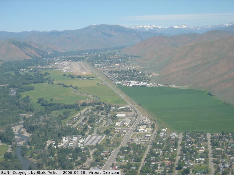
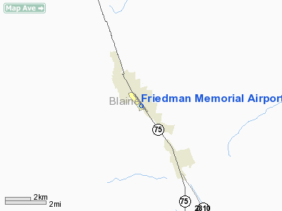
Friedman Memorial Airport (IATA: SUN, ICAO: KSUN, FAA LID: SUN) is a city-owned public-use airport located one nautical mile (2 km) southeast of the central business district of Hailey, a city in Blaine County, Idaho, United States. The airport is operated by the Friedman Memorial Airport Authority under a Joint Powers Agreement between the City of Hailey and Blaine County. It serves Sun Valley and the surrounding areas in the Wood River Valley. Facilities and aircraft
Friedman Memorial Airport covers an area of 171 acres (69 ha) at an elevation of 5,318 feet (1,621 m) above mean sea level. It has one asphalt paved runway designated 13/31 which measures 7,550 by 100 feet (2,301 x 30 m).
For the 12-month period ending May 31, 2007, the airport had 68,540 aircraft operations, an average of 187 per day: 58% general aviation, 38% air taxi, 3% scheduled commercial and <1% military. At that time there were 150 aircraft based at this airport: 67% single-engine, 25% multi-engine, 5% jet, 1% helicopter and 1% ultralight.
Delta is the dominant carrier at the airport with the most flights and flies to its Salt Lake City hub only. Alaska is the only other carrier at the airport. More flights operate during the winter ski season than any other time of year from the airport.
Airlines and destinations
| Airlines |
Destinations |
| Horizon Air |
Seattle/Tacoma, Los Angeles [seasonal], Boise |
| Delta Connection operated by SkyWest Airlines |
Salt Lake City |
The above content comes from Wikipedia and is published under free licenses – click here to read more.
|
 |
(Click on the photo to enlarge) |
Location
& QuickFacts
|
FAA
Information Effective: |
2007-07-05 |
|
Airport
Identifier: |
SUN |
|
Airport
Status: |
Operational |
|
Longitude/Latitude: |
114-17-43.9900W/43-30-13.6040N
-114.295553/43.503779 (Estimated) |
|
Elevation: |
5318 ft / 1620.93 m (Estimated) |
|
Land: |
171 acres |
|
From
nearest city: |
1 nautical miles SE of Hailey, ID |
|
Location: |
Blaine County, ID |
|
Magnetic Variation: |
16E (1995) |
Owner
& Manager
|
Ownership: |
Publicly
owned |
|
Owner: |
City Of Hailey
AND COUNTY OF BLAINE. |
|
Address: |
Blane Co - Box 400
Hailey, ID 83333 |
|
Phone
number: |
208-788-5500 |
|
Manager: |
Richard R Baird |
|
Address: |
P.o. Box 929
Hailey, ID 83333 |
|
Phone number: |
208-788-4956 |
Airport Operations and Facilities
|
Airport
Use: |
Open
to public |
|
Wind
indicator: |
Yes |
|
Segmented Circle: |
No |
|
Control
Tower: |
Yes |
|
Lighting
Schedule: |
DUSK-DAWN
ACTVT HIRL RY 13/31 - CTAF WHEN ATCT CLSD.
PAPI
RY 31 OPER 24 HRS. |
|
Beacon
Color: |
Clear-Green (lighted land airport) |
|
Landing
fee charge: |
Yes
LNDG FEE FOR ACFT GTR THAN 6000 LBS. |
|
Sectional chart: |
Salt Lake City |
|
Region: |
ANM - Northwest Mountain |
|
Boundary
ARTCC: |
ZLC - Salt Lake City |
|
Tie-in
FSS: |
BOI - Boise |
|
FSS
on Airport: |
No |
|
FSS
Phone: |
208-332-0200 |
|
FSS
Toll Free: |
1-800-WX-BRIEF |
|
NOTAMs
Facility: |
SUN (NOTAM-d service avaliable) |
|
Certification type/date: |
I A S 10/1974
PPR FOR ALL UNSKED ACFT OPNS UTILIZING ACFT WITH A TYPE
CERTIFICATE FOR MORE THAN 30 PAX SEATS. PPR FOR ALL SKED
ACR OPNS BTN 2300-0600 CALL AMGR (208) 788-4956. |
|
Federal Agreements: |
NGY |
Airport Communications
|
CTAF: |
125.600 |
|
Unicom: |
122.950 |
Airport Services
|
Fuel
available: |
100LLA1+
FUEL AVBL AFT DUSK PPR 208-788-9511. |
|
Airframe
Repair: |
MAJOR |
|
Power
Plant Repair: |
MAJOR |
|
Bottled
Oxygen: |
HIGH |
|
Bulk
Oxygen: |
HIGH |
|
Runway Information
Runway 13/31
|
Dimension: |
7550
x 100 ft / 2301.2 x 30.5 m |
|
Surface: |
ASPH, Fair Condition |
|
Surface
Treatment: |
Porous Friction Course |
|
Weight
Limit: |
Single wheel: 65000 lbs.
Dual wheel: 95000 lbs.
Dual tandem wheel: 150000 lbs. |
|
Edge
Lights: |
High |
|
|
Runway 13 |
Runway 31 |
|
Longitude: |
114-18-13.5420W |
114-17-14.4650W |
|
Latitude: |
43-30-44.0620N |
43-29-43.1430N |
|
Elevation: |
5319.00 ft |
5262.00 ft |
|
Alignment: |
127 |
127 |
|
Traffic
Pattern: |
Left |
Left |
|
Markings: |
Non-precision instrument, Fair Condition |
Precision instrument, Fair Condition |
|
Crossing
Height: |
0.00 ft |
55.00 ft |
|
Displaced
threshold: |
1701.00 ft |
0.00 ft |
|
VASI: |
|
4-light PAPI on left side |
|
Visual
Glide Angle: |
0.00° |
3.50° |
|
Obstruction: |
17 ft road, 200.0 ft from runway, 190 ft left
of centerline
ROAD 65:1 TO DSPLCD THR; PARKED ACFT 0' 225' L, 0:1 BASED
ON DSPLCD THR.
+17 FT ROAD 450 FT FM THLD 250 FT L, +15 FT PIPES 500 FT FM
THLD 180 FT R, +7 FT FENCE 550 FT FM THLD 180 FT L, +17 FT
ROAD 550 FT FM THLD 190 FT L. |
64 ft tree, 1600.0 ft from runway, 600 ft left
of centerline, 21:1 slope to clear |
|
Decleard
distances: |
Take off run available 7550.00 ft
Take off distance available 7550.00 ft
Actual stop distance available 7150.00 ft
Landing distance available 5449.00 ft |
Take off run available 5849.00 ft
Take off distance available 7550.00 ft
Actual stop distance available 6600.00 ft
Landing distance available 6600.00 ft |
|
Radio Navigation
Aids
|
ID |
Type |
Name |
Ch |
Freq |
Var |
Dist |
|
HDG |
NDB |
Steelhead |
|
211.00 |
16E |
39.0 nm |
|
AOC |
NDB |
Arco |
|
200.00 |
15E |
41.9 nm |
|
HLE |
NDB/DME |
Hailey |
025X |
220.00 |
16E |
10.8 nm |
Remarks
- WHEN
ATCT CLSD - LAND RY 31 TAKEOFF RY 13; DUE TO OPPOSITE DIRECTION TRAFFIC
USE LANDING LIGHT IN TRAFFIC PATTERN.
- DUE
TO OPPOSITE TFC: APCH RY 31 ALONG E SIDE OF VALLEY: DEP RY 13 ALONG
W SIDE OF VALLEY: SHOW LNGD LGT.
- NO
LOCKED BRAKE TURNS.
- APU
OPERATION LIMITED TO 30 MINS WITHOUT EXCEPTION.
- TAXIWAYS
A-5 AND B-5 RESTRICTED TO AIRCRAFT WITH WINGSPANS OF 49' OR LESS (AIRCRAFT
DESIGN GROUP I) ONLY.
- TWY
A OPEN BTN A2 & A3 DLGT HRS ONLY.
- NO
LINE OF SIGHT BTWN RY ENDS.
- BACK
TAXIING ON RY 31 NOT AUTHORIZED WHEN ATCT IS CLSD.
- NOT
RCMDD FOR NIGHT USE OR IN MARGINAL WEATHER BY UNFAMILIAR PILOTS DUE
TO MOUNTAINOUS TERRAIN.
- BIRD
ACTIVITY SE END RY 31.
- CTC
AMGR 208-788-4956 OR 208-788-3702 FOR NOISE ABATEMENT PROCEDURES.
APU OPERATION LIMITED
TO 30 MINUTE MAXIUM RUN TIME.
- ESTABD
PRIOR TO 1959.
Based
Aircraft
|
Aircraft
based on field: |
152 |
|
Single
Engine Airplanes: |
101 |
|
Multi
Engine Airplanes: |
38 |
|
Jet
Engine Airplanes: |
8 |
|
Helicopters: |
2 |
|
Gliders: |
1 |
|
Ultralights: |
2 |
Major Carriers
Serving This Airport
|
Skywest Airlines Inc. |
100.0% |
Most Popular Destinations
|
Salt Lake City Intl (SLC) |
99.8% |
|
Joslin Field - Magic Valley Rgnl (TWF) |
0.2% |
Most Popular Aircraft
|
N236SW |
6.3% |
|
N214SW |
5.9% |
|
N576SW |
5.9% |
|
N291SW |
5.8% |
|
N566SW |
5.4% |
|
N584SW |
4.7% |
|
N232SW |
4.5% |
|
N237SW |
4.1% |
|
N297SW |
4.1% |
|
N580SW |
3.9% |
Operational Statistics
Time Period: 2004-07-01
- 2005-06-30
|
Aircraft
Operations: |
292/Day |
|
Commerical: |
2.3% |
|
Air
Taxi: |
22.8% |
|
General
Aviation Local: |
4.4% |
|
General
Aviation Itinerant: |
70.4% |
|
Military: |
0.1% |
Friedman Memorial Airport
Address:
Blaine County, ID
Tel:
208-788-5500,
208-788-4956
Images
and information placed above are from
http://www.airport-data.com/airport/SUN/
We
thank them for the data!
| General
Info |
| Country |
United
States |
| State |
IDAHO
|
| FAA ID |
SUN |
| Latitude |
43-30-14.600N
|
| Longitude |
114-17-45.000W
|
| Elevation |
5317 feet
|
| Near City |
HAILEY
|
We don't guarantee the information is fresh and accurate. The data may
be wrong or outdated.
For more up-to-date information please refer to other sources.
|
|