 |
|
Craigmont Municipal Airport |
|
|
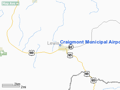
Location
& QuickFacts
|
FAA
Information Effective: |
2007-07-05 |
|
Airport
Identifier: |
S89 |
|
Airport
Status: |
Operational |
|
Longitude/Latitude: |
116-28-48.5210W/46-14-49.5930N
-116.480145/46.247109 (Estimated) |
|
Elevation: |
3805 ft / 1159.76 m (Estimated) |
|
Land: |
80 acres |
|
From
nearest city: |
0 nautical miles N of Craigmont, ID |
|
Location: |
Lewis County, ID |
|
Magnetic Variation: |
18E (1985) |
Owner
& Manager
|
Ownership: |
Publicly
owned |
|
Owner: |
City Of Craigmont |
|
Address: |
P O Box 250
Craigmont, ID 83523-0250 |
|
Phone
number: |
208-924-5432 |
|
Manager: |
Lalisa Thomason |
|
Address: |
P O Box 250
Craigmont, ID 83523 |
|
Phone number: |
208-924-5432 |
Airport Operations and Facilities
|
Airport
Use: |
Open
to public |
|
Wind
indicator: |
Yes |
|
Segmented Circle: |
No |
|
Control
Tower: |
No |
|
Lighting
Schedule: |
DUSK-DAWN |
|
Beacon
Color: |
Clear-Green (lighted land airport) |
|
Landing
fee charge: |
No |
|
Sectional chart: |
Great Falls |
|
Region: |
ANM - Northwest Mountain |
|
Boundary
ARTCC: |
ZSE - Seattle |
|
Tie-in
FSS: |
BOI - Boise |
|
FSS
on Airport: |
No |
|
FSS
Phone: |
208-332-0200 |
|
FSS
Toll Free: |
1-800-WX-BRIEF |
|
NOTAMs
Facility: |
BOI (NOTAM-d service avaliable) |
|
Federal Agreements: |
N1 |
Airport Communications
Airport
Services
|
Airframe
Repair: |
MINOR |
|
Power
Plant Repair: |
MINOR |
|
Bottled
Oxygen: |
NONE |
|
Bulk
Oxygen: |
NONE |
|
Runway Information
Runway 07/25
|
Dimension: |
2800
x 50 ft / 853.4 x 15.2 m |
|
Surface: |
ASPH, Good Condition |
|
Edge
Lights: |
Medium |
|
|
Runway 07 |
Runway 25 |
|
Traffic
Pattern: |
Left |
Left |
|
Markings: |
Basic, Good Condition |
Basic, Good Condition |
|
Displaced
threshold: |
0.00 ft |
300.00 ft
RWY 25 THLD DSPLCD 300 FT NGTS; MKD WITH DSPLCD THLD LIGHTS
AND RUNWAY MARKING. |
|
Obstruction: |
, 50:1 slope to clear |
7 ft gnd, 200.0 ft from runway
+16 FT ROAD AT 335 FT ON CNTRLN; 20:1 BASED ON DSPLCD THLD.
+16 FT ROAD 35 FT FM RY END ON CNTRLN. |
|
Radio Navigation
Aids
|
ID |
Type |
Name |
Ch |
Freq |
Var |
Dist |
|
GVV |
NDB |
Grain |
|
280.00 |
18E |
21.4 nm |
|
MQG |
VOR/DME |
Nez Perce |
019X |
108.20 |
20E |
18.1 nm |
|
PUW |
VOR/DME |
Pullman |
027X |
109.00 |
20E |
40.1 nm |
Remarks
- HEAVY
CROP DUSTING OPNS MAR 1 - JULY 31.
- ESTABD
PRIOR TO 5/15/59.
Based
Aircraft
|
Aircraft
based on field: |
7 |
|
Single
Engine Airplanes: |
7 |
Operational Statistics
Time Period: 2005-08-11
- 2006-08-10
|
Aircraft
Operations: |
246/Week |
|
General
Aviation Local: |
5.9% |
|
General
Aviation Itinerant: |
94.1% |
Craigmont Municipal Airport
Address:
Lewis County, ID
Tel:
208-924-5432
Images
and information placed above are from
http://www.airport-data.com/airport/S89/
We
thank them for the data!
| General
Info |
| Country |
United
States |
| State |
IDAHO
|
| FAA ID |
S89 |
| Latitude |
46-14-49.593N
|
| Longitude |
116-28-48.521W
|
| Elevation |
3805 feet
|
| Near City |
CRAIGMONT
|
We don't guarantee the information is fresh and accurate. The data may
be wrong or outdated.
For more up-to-date information please refer to other sources.
|
|


