 |
|
Coeur D'alene Resort Heliport |
Coordinates: 47°46â²28â³N 116°49â²10â³W / 47.77444°N 116.81944°W / 47.77444; -116.81944
Coeur d'Alene Airport
Pappy Boyington Field |
| IATA: COE â ICAO: KCOE â FAA LID: COE |
| Summary |
| Airport type |
Public |
| Owner |
Kootenai County |
| Serves |
Coeur d'Alene, Idaho |
| Location |
Hayden, Idaho |
| Elevation AMSL |
2,320 ft / 707 m |
| Website |
www.cdaairport.com |
| Runways |
| Direction |
Length |
Surface |
| ft |
m |
| 5/23 |
7,400 |
2,256 |
Asphalt |
| 1/19 |
5,400 |
1,646 |
Asphalt |
| Statistics (2007) |
| Aircraft operations |
123,048 |
| Based aircraft |
186 |
| Sources: airport website and FAA |
Coeur d'Alene Airport (IATA: COE, ICAO: KCOE, FAA LID: COE) is a county-owned public-use airport located in Hayden, a city in Kootenai County, Idaho, United States. The airport is nine miles (14 km) northwest of the central business district of Coeur d'Alene. It was known as Coeur d'Alene Air Terminal until September 2007 when it was renamed Coeur d'Alene Airport / Pappy Boyington Field to honor World War II hero Col. Gregory "Pappy" Boyington who was born in Coeur d'Alene.
Facilities and aircraft
Coeur d'Alene Airport covers an area of 1,140 acres (461 ha) which contains two asphalt paved runways: 5/23 measuring 7,400 x 100 ft (2,256 x 30 m) and 1/19 measuring 5,400 x 75 ft (1,646 x 23 m).
For the 12-month period ending May 31, 2007, the airport had 123,048 aircraft operations, an average of 337 per day: 77% general aviation, 22% air taxi and 1% military. There are 186 aircraft based at this airport: 81% single-engine, 8% multi-engine, 5% jet, 5% helicopter, 1% ultralight and <1% glider.
The above content comes from Wikipedia and is published under free licenses – click here to read more.
Location
& QuickFacts
|
FAA
Information Effective: |
2007-07-05 |
|
Airport
Identifier: |
COE |
|
Airport
Status: |
Operational |
|
Longitude/Latitude: |
116-49-10.5000W/47-46-27.5000N
-116.819583/47.774306 (Estimated) |
|
Elevation: |
2320 ft / 707.14 m (Surveyed) |
|
Land: |
1140 acres |
|
From
nearest city: |
9 nautical miles NW of Coeur D'alene, ID |
|
Location: |
Kootenai County, ID |
|
Magnetic Variation: |
19E (1990) |
Owner
& Manager
|
Ownership: |
Publicly
owned |
|
Owner: |
Kootenai County |
|
Address: |
Po Box 9000
Coeur D Alene, ID 83816 |
|
Phone number: |
208-446-1600 |
|
Manager: |
Greg Delavan
AIRPORT DIRECTOR |
|
Address: |
10375 Sensor Ave
Hayden, ID 83835 |
|
Phone number: |
208-446-1860 |
Airport
Operations and Facilities
|
Airport
Use: |
Open
to public |
|
Wind
indicator: |
Yes |
|
Segmented Circle: |
Yes |
|
Control
Tower: |
No |
|
Lighting
Schedule: |
DUSK-DAWN
ACTVT MIRL RY 01/19, HIRL RY 05/23, REIL RYS 01&23,
MALSR RY 05 AND PAPI RYS 01, 19, 05, & 23 - CTAF. |
|
Beacon
Color: |
Clear-Green (lighted land airport) |
|
Landing
fee charge: |
No |
|
Sectional chart: |
Great Falls |
|
Region: |
ANM - Northwest Mountain |
|
Boundary
ARTCC: |
ZSE - Seattle |
|
Tie-in
FSS: |
BOI - Boise |
|
FSS
on Airport: |
No |
|
FSS
Phone: |
208-332-0200 |
|
FSS
Toll Free: |
1-800-WX-BRIEF |
|
NOTAMs
Facility: |
COE (NOTAM-d service avaliable) |
|
Certification type/date: |
I L U 11/1998
48 HR PPR FOR UNSKED OPNS WITH MORE THAN 30 PSGR SEATS CALL
AMGR 208-446-1860. |
|
Federal Agreements: |
NGY3 |
Airport Communications
|
CTAF: |
122.800 |
|
Unicom: |
122.800
|
Airport
Services
|
Fuel
available: |
100 A
FOR AFTER HRS FUEL-SELF SVC AVBL OR CALL 208-772-6404, 208-661-4174,
208-661-7449, 208-699-5433. |
|
Airframe
Repair: |
MAJOR |
|
Power
Plant Repair: |
MAJOR |
|
Bottled
Oxygen: |
HIGH/LOW |
|
Bulk
Oxygen: |
HIGH/LOW |
|
Runway Information
Runway 01/19
|
Dimension: |
5400
x 75 ft / 1645.9 x 22.9 m |
|
Surface: |
ASPH, Good Condition |
|
Weight
Limit: |
Single wheel: 50000 lbs.
Dual wheel: 83000 lbs.
Dual tandem wheel: 150000 lbs. |
|
Edge
Lights: |
Medium |
|
|
Runway 01 |
Runway 19 |
|
Longitude: |
116-49-15.1160W |
116-48-32.8145W |
|
Latitude: |
47-45-59.7652N |
47-46-44.7812N |
|
Elevation: |
2305.00 ft |
2319.00 ft |
|
Alignment: |
32 |
127 |
|
Traffic
Pattern: |
Right |
Left |
|
Markings: |
Non-precision instrument, Good Condition |
Non-precision instrument, Good Condition |
|
Crossing
Height: |
39.00 ft |
41.00 ft |
|
VASI: |
2-light PAPI on left side |
2-light PAPI on left side |
|
Visual
Glide Angle: |
3.00° |
3.00° |
|
Runway
End Identifier: |
Yes |
|
|
Runway 05/23
|
Dimension: |
7400
x 100 ft / 2255.5 x 30.5 m |
|
Surface: |
ASPH, Good Condition |
|
Surface
Treatment: |
Saw-cut or plastic Grooved |
|
Weight
Limit: |
Single wheel: 57000 lbs.
Dual wheel: 95000 lbs.
Dual tandem wheel: 165000 lbs. |
|
Edge
Lights: |
High |
|
|
Runway 05 |
Runway 23 |
|
Longitude: |
116-50-13.4983W |
116-48-31.6626W |
|
Latitude: |
47-46-18.8741N |
47-46-43.7763N |
|
Elevation: |
2277.00 ft |
2320.00 ft |
|
Alignment: |
70 |
127 |
|
ILS
Type: |
ILS |
|
|
Traffic
Pattern: |
Left |
Left |
|
Markings: |
Precision instrument, Good Condition |
Precision instrument, Good Condition |
|
Crossing
Height: |
56.00 ft |
50.00 ft |
|
VASI: |
4-light PAPI on right side |
4-light PAPI on right side |
|
Visual
Glide Angle: |
3.00° |
3.00° |
|
Approach
lights: |
MALSR |
|
|
Runway
End Identifier: |
|
Yes |
|
Radio Navigation
Aids
|
ID |
Type |
Name |
Ch |
Freq |
Var |
Dist |
|
SFF |
NDB |
Felts |
|
365.00 |
19E |
20.6 nm |
|
DPY |
NDB |
Deer Park |
|
216.00 |
19E |
27.1 nm |
|
SZT |
NDB |
Sandpoe |
|
264.00 |
20E |
32.7 nm |
|
SKA |
TACAN |
Fairchild |
051X |
|
19E |
35.5 nm |
|
GEG |
VORTAC |
Spokane |
102X |
115.50 |
21E |
35.0 nm |
|
SFF |
VOT |
Spokane/felts Field |
|
114.00 |
|
21.0 nm |
|
GEG |
VOT |
Spokane Intl |
|
109.60 |
|
30.6 nm |
Remarks
- ARPT
CONDS AVBL ON AWOS.
- MIGRATORY
BIRDS ON & INVOF ARPT OCT-NOV.
Based
Aircraft
|
Aircraft
based on field: |
186 |
|
Single
Engine Airplanes: |
150 |
|
Multi
Engine Airplanes: |
15 |
|
Jet
Engine Airplanes: |
9 |
|
Helicopters: |
9 |
|
Gliders: |
1 |
|
Ultralights: |
2 |
Operational Statistics
Time Period: 2004-01-01
- 2004-12-30
|
Aircraft
Operations: |
338/Day |
|
Air
Taxi: |
22.1% |
|
General
Aviation Local: |
29.6% |
|
General
Aviation Itinerant: |
47.2% |
|
Military: |
1.2% |
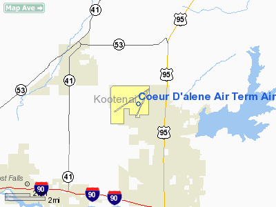
Coeur D'alene Air Term Airport
Address:
Kootenai County, ID
Tel:
208-446-1600, 208-446-1860
Images
and information placed above are from
http://www.airport-data.com/airport/COE/
We
thank them for the data!
| General
Info |
| Country |
United
States |
| State |
IDAHO
|
| FAA ID |
COE |
| Latitude |
47-46-27.450N
|
| Longitude |
116-49-10.643W
|
| Elevation |
2318 feet
|
| Near City |
COEUR
D'ALENE |
We don't guarantee the information is fresh and accurate. The data may
be wrong or outdated.
For more up-to-date information please refer to other sources.
|
|


