 |
|
| Challis Airport |
| IATA: CHL â ICAO: KLLJ â FAA LID: LLJ |
| Summary |
| Airport type |
Public |
| Owner |
City of Challis |
| Location |
Challis, Idaho |
| Elevation AMSL |
5,072 ft / 1,546 m |
| Coordinates |
44°31â²25â³N 114°13â²04â³W / 44.52361°N 114.21778°W / 44.52361; -114.21778 |
| Runways |
| Direction |
Length |
Surface |
| ft |
m |
| 16/34 |
4,600 |
1,402 |
Asphalt |
| Statistics (2006) |
| Aircraft operations |
16,350 |
| Source: Federal Aviation Administration |
Challis Airport (IATA: CHL, ICAO: KLLJ, FAA LID: LLJ) is a city-owned public-use airport located one mile (2 km) northeast of the central business district of Challis, a city in Custer County, Idaho, United States.
Although most U.S. airports use the same three-letter location identifier for the FAA and IATA, Challis Airport is assigned LLJ by the FAA and CHL by the IATA (which assigned LLJ to Lalmonirhat, Bangladesh).
Facilities and aircraft
Challis Airport covers an area of 149 acres (60 ha) which contains one asphalt paved runway (16/34) measuring 4,600 x 60 ft (1,402 x 18 m). For the 12-month period ending May 22, 2006, the airport had 16,350 aircraft operations, an average of 44 per day: 65% general aviation, 34% air taxi and 1% military.
The above content comes from Wikipedia and is published under free licenses – click here to read more.
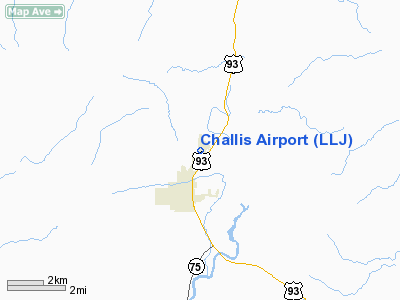
Location
& QuickFacts
|
FAA
Information Effective: |
2007-07-05 |
|
Airport
Identifier: |
LLJ |
|
Airport
Status: |
Operational |
|
Longitude/Latitude: |
114-13-03.2310W/44-31-22.7210N
-114.217564/44.522978 (Estimated) |
|
Elevation: |
5072 ft / 1545.95 m (Estimated) |
|
Land: |
149 acres |
|
From
nearest city: |
1 nautical miles NE of Challis, ID |
|
Location: |
Custer County, ID |
|
Magnetic Variation: |
17E (1985) |
Owner & Manager
|
Ownership: |
Publicly owned |
|
Owner: |
City Of Challis |
|
Address: |
Po Box 587
Challis, ID 83226 |
|
Phone number: |
208-879-2386 |
|
Manager: |
Bob Fratti |
|
Address: |
Po Box 246
Challis, ID 83226 |
|
Phone number: |
208-879-4201 |
Airport
Operations and Facilities
|
Airport
Use: |
Open
to public |
|
Wind
indicator: |
Yes |
|
Segmented Circle: |
Yes |
|
Control
Tower: |
No |
|
Lighting
Schedule: |
DUSK-DAWN |
|
Beacon
Color: |
Clear-Green (lighted land airport) |
|
Landing
fee charge: |
No |
|
Sectional chart: |
Great Falls |
|
Region: |
ANM - Northwest Mountain |
|
Boundary
ARTCC: |
ZLC - Salt Lake City |
|
Tie-in
FSS: |
BOI - Boise |
|
FSS
on Airport: |
No |
|
FSS
Phone: |
208-332-0200 |
|
FSS
Toll Free: |
1-800-WX-BRIEF |
|
NOTAMs
Facility: |
LLJ (NOTAM-d service avaliable) |
|
Federal Agreements: |
NGY |
Airport Communications
|
CTAF: |
122.800 |
|
Unicom: |
122.800
|
Airport
Services
|
Fuel
available: |
100
A |
|
Airframe
Repair: |
MAJOR |
|
Power
Plant Repair: |
MAJOR |
|
Bottled
Oxygen: |
NONE |
|
Runway Information
Runway 16/34
|
Dimension: |
4600
x 60 ft / 1402.1 x 18.3 m |
|
Surface: |
ASPH, Good Condition |
|
Weight
Limit: |
Single wheel: 30000 lbs. |
|
Edge
Lights: |
Medium |
|
|
Runway 16 |
Runway 34 |
|
Traffic
Pattern: |
Left |
Left |
|
Markings: |
Basic, Fair Condition |
Basic, Fair Condition |
|
Crossing
Height: |
0.00 ft |
40.00 ft |
|
VASI: |
|
4-light PAPI on left side |
|
Visual
Glide Angle: |
0.00° |
3.00° |
|
Obstruction: |
4 ft fence, 300.0 ft from runway, 25:1 slope
to clear |
62 ft pline, 1450.0 ft from runway, 20:1 slope
to clear |
|
Radio Navigation
Aids
|
ID |
Type |
Name |
Ch |
Freq |
Var |
Dist |
|
LLJ |
NDB |
Challis |
|
397.00 |
17E |
0.2 nm |
|
LKT |
VOR/DME |
Salmon |
082X |
113.50 |
18E |
30.5 nm |
Remarks
- BE
ALERT HELICOPTER OPNS ADJACENT SOUTHEAST END OF ARPT.
- AMOS
WX STN ON ARPT.
- ARPT
LCTD IN HIGH MTN VALLEY.
- DEER
ON & INVOF ARPT.
- ESTABD
PRIOR TO 1959.
Based
Aircraft
|
Aircraft
based on field: |
17 |
|
Single
Engine Airplanes: |
15 |
|
Multi
Engine Airplanes: |
1 |
|
Helicopters: |
1 |
Operational Statistics
Time Period: 2005-05-23
- 2006-05-22
|
Aircraft
Operations: |
45/Day |
|
Air
Taxi: |
33.6% |
|
General
Aviation Local: |
13.5% |
|
General
Aviation Itinerant: |
52.0% |
|
Military: |
0.9% |
Challis Airport
Address:
Custer County, ID
Tel:
208-879-2386, 208-879-4201
Images
and information placed above are from
http://www.airport-data.com/airport/LLJ/
We
thank them for the data!
| General
Info |
| Country |
United
States |
| State |
IDAHO
|
| FAA ID |
LLJ |
| Latitude |
44-31-22.721N
|
| Longitude |
114-13-03.231W
|
| Elevation |
5072 feet
|
| Near City |
CHALLIS
|
We don't guarantee the information is fresh and accurate. The data may
be wrong or outdated.
For more up-to-date information please refer to other sources.
|
|


