 |
|
|
|
|
|
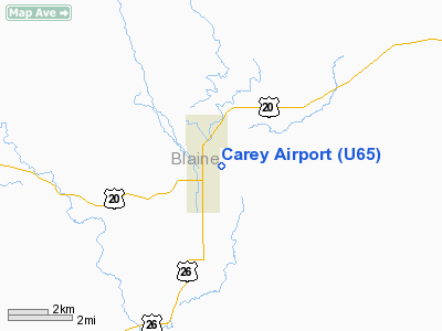
Location
& QuickFacts
|
FAA
Information Effective: |
2007-07-05 |
|
Airport
Identifier: |
U65 |
|
Airport
Status: |
Operational |
|
Longitude/Latitude: |
113-56-03.1040W/43-18-29.6580N
-113.934196/43.308238 (Estimated) |
|
Elevation: |
4783 ft / 1457.86 m (Surveyed) |
|
Land: |
23 acres |
|
From
nearest city: |
0 nautical miles E of Carey, ID |
|
Location: |
Blaine County, ID |
|
Magnetic Variation: |
16E (1985) |
Owner
& Manager
|
Ownership: |
Publicly
owned |
|
Owner: |
City Of Carey |
|
Address: |
Box 6
Carey, ID 83320 |
|
Phone
number: |
208-823-4045 |
|
Manager: |
Craig Adamson |
|
Address: |
P. O. Box 31
Carey, ID 83320 |
|
Phone number: |
208-481-1957 |
Airport Operations and Facilities
|
Airport
Use: |
Open
to public |
|
Wind
indicator: |
Yes |
|
Segmented Circle: |
Yes
PARTIAL, NON-STD WESTEND. FULL CIRCLE ON EAST END. |
|
Control
Tower: |
No |
|
Landing
fee charge: |
No |
|
Sectional chart: |
Salt Lake City |
|
Region: |
ANM - Northwest Mountain |
|
Boundary
ARTCC: |
ZLC - Salt Lake City |
|
Tie-in
FSS: |
BOI - Boise |
|
FSS
on Airport: |
No |
|
FSS
Phone: |
208-332-0200 |
|
FSS
Toll Free: |
1-800-WX-BRIEF |
|
NOTAMs
Facility: |
BOI (NOTAM-d service avaliable) |
|
Federal Agreements: |
1 |
Airport Communications
Airport Services
|
Airframe
Repair: |
NONE |
|
Power
Plant Repair: |
NONE |
|
Bottled
Oxygen: |
NONE |
|
Bulk
Oxygen: |
NONE |
|
Runway Information
Runway 07/25
|
Dimension: |
2650
x 170 ft / 807.7 x 51.8 m |
|
Surface: |
TURF, Good Condition |
|
|
Runway 07 |
Runway 25 |
|
Traffic
Pattern: |
Left |
Left |
|
Obstruction: |
4 ft fence, 100 ft right of centerline |
5 ft fence, 25.0 ft from runway, 5:1 slope
to clear |
|
Radio Navigation
Aids
|
ID |
Type |
Name |
Ch |
Freq |
Var |
Dist |
|
AOC |
NDB |
Arco |
|
200.00 |
15E |
31.2 nm |
|
HDG |
NDB |
Steelhead |
|
211.00 |
16E |
40.1 nm |
|
HLE |
NDB/DME |
Hailey |
025X |
220.00 |
16E |
13.5 nm |
|
BYI |
VOR/DME |
Burley |
088X |
114.10 |
18E |
43.9 nm |
Remarks
- RECOMMEND
LAND RWY 25; TKOF RWY 7 WHEN WND CONDITIONS PERMIT.
- NUMEROUS
30' TO 90' TREES AT 900' TO 1200' FM EOR 07.
- BE
ALERT FOR SPRINKLERS ON RY.
- ESTABD
PRIOR TO 1959.
Based
Aircraft
|
Aircraft
based on field: |
7 |
|
Single
Engine Airplanes: |
7 |
Operational Statistics
Time Period: 2003-11-25
- 2004-11-23
|
Aircraft
Operations: |
47/Week |
|
General
Aviation Local: |
50.0% |
|
General
Aviation Itinerant: |
50.0% |
Carey Airport
Address:
Blaine County, ID
Tel:
208-823-4045,
208-481-1957
Images
and information placed above are from
http://www.airport-data.com/airport/U65/
We
thank them for the data!
| General
Info |
| Country |
United
States |
| State |
IDAHO
|
| FAA ID |
U65 |
| Latitude |
43-18-29.658N
|
| Longitude |
113-56-03.104W
|
| Elevation |
4783 feet
|
| Near City |
CAREY
|
We don't guarantee the information is fresh and accurate. The data may
be wrong or outdated.
For more up-to-date information please refer to other sources.
|
|


