 |
|
Caldwell Industrial Airport |
| Caldwell Industrial Airport |
| IATA: none â ICAO: KEUL â FAA LID: EUL |
| Summary |
| Airport type |
Public |
| Owner |
City of Caldwell |
| Location |
Caldwell, Idaho |
| Elevation AMSL |
2,431 ft / 741 m |
| Coordinates |
43°38â²31â³N 116°38â²09â³W / 43.64194°N 116.63583°W / 43.64194; -116.63583 |
| Runways |
| Direction |
Length |
Surface |
| ft |
m |
| 12/30 |
5,500 |
1,676 |
Asphalt |
| Statistics (2007) |
| Aircraft operations |
147,325 |
| Based aircraft |
533 |
| Source: Federal Aviation Administration |
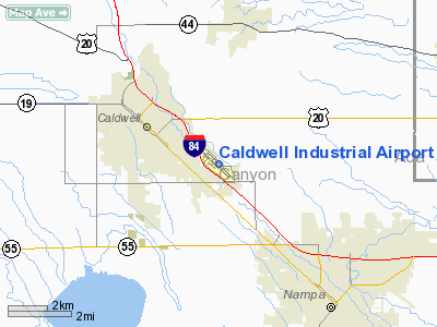
Caldwell Industrial Airport (ICAO: KEUL, FAA LID: EUL) is a city-owned public-use airport located three miles (5 km) southeast of the central business district of Caldwell, a city in Canyon County, Idaho, United States.
Although most U.S. airports use the same three-letter location identifier for the FAA and IATA, Caldwell Industrial Airport is assigned EUL by the FAA but has no designation from the IATA.
Facilities and aircraft
Caldwell Industrial Airport covers an area of 154 acres (62 ha) which contains one asphalt paved runway (12/30) measuring 5,500 x 100 ft (1,676 x 30 m). For the 12-month period ending June 21, 2007, the airport had 147,325 aircraft operations, an average of 403 per day: 98% general aviation, 1% air taxi and <1% military. There are 533 aircraft based at this airport: 92% single-engine, 3% multi-engine, 3% ultralight, 2% helicopter and <1% jet.
The above content comes from Wikipedia and is published under free licenses – click here to read more.
Location
& QuickFacts
|
FAA
Information Effective: |
2007-07-05 |
|
Airport
Identifier: |
EUL |
|
Airport
Status: |
Operational |
|
Longitude/Latitude: |
116-38-08.8000W/43-38-30.7000N
-116.635778/43.641861 (Estimated) |
|
Elevation: |
2431 ft / 740.97 m (Surveyed) |
|
Land: |
154 acres |
|
From
nearest city: |
3 nautical miles SE of Caldwell, ID |
|
Location: |
Canyon County, ID |
|
Magnetic Variation: |
16E (2000) |
Owner & Manager
|
Ownership: |
Publicly owned |
|
Owner: |
City Of Caldwell |
|
Address: |
Po Box 1177
Caldwell, ID 83606 |
|
Phone number: |
208-455-3000 |
|
Manager: |
Curt Hawkins |
|
Address: |
4601-4 Aviation Way
Caldwell, ID 83605 |
|
Phone number: |
208-459-9779 |
Airport
Operations and Facilities
|
Airport
Use: |
Open
to public |
|
Wind
indicator: |
Yes |
|
Segmented Circle: |
Yes |
|
Control
Tower: |
No |
|
Lighting
Schedule: |
DUSK-DAWN
ACTVT MIRL RY 12/30 - CTAF. PAPI
RYS 12 & 30 OPER 24 HRS. |
|
Beacon
Color: |
Clear-Green (lighted land airport) |
|
Landing
fee charge: |
No |
|
Sectional chart: |
Salt Lake City |
|
Region: |
ANM - Northwest Mountain |
|
Boundary
ARTCC: |
ZLC - Salt Lake City |
|
Tie-in
FSS: |
BOI - Boise |
|
FSS
on Airport: |
No |
|
FSS
Phone: |
208-332-0200 |
|
FSS
Toll Free: |
1-800-WX-BRIEF |
|
NOTAMs
Facility: |
EUL (NOTAM-d service avaliable) |
|
Federal Agreements: |
NGY |
Airport Communications
|
CTAF: |
122.700 |
|
Unicom: |
122.700
|
Airport
Services
|
Fuel
available: |
100LLA |
|
Airframe
Repair: |
MAJOR |
|
Power
Plant Repair: |
MAJOR |
|
Bottled
Oxygen: |
NONE |
|
Bulk
Oxygen: |
NONE |
|
Runway Information
Runway 12/30
|
Dimension: |
5500
x 100 ft / 1676.4 x 30.5 m |
|
Surface: |
ASPH, Good Condition |
|
Weight
Limit: |
Single wheel: 72000 lbs.
Dual wheel: 86000 lbs. |
|
Edge
Lights: |
Medium |
|
|
Runway 12 |
Runway 30 |
|
Longitude: |
116-38-35.1410W |
116-37-42.3620W |
|
Latitude: |
43-38-49.8930N |
43-38-11.4130N |
|
Elevation: |
2426.00 ft |
2431.00 ft |
|
Alignment: |
127 |
127 |
|
Traffic
Pattern: |
Left |
Right |
|
Markings: |
Non-precision instrument, Good Condition |
Non-precision instrument, Good Condition |
|
Crossing
Height: |
42.00 ft |
45.00 ft |
|
VASI: |
4-light PAPI on left side |
4-light PAPI on left side |
|
Visual
Glide Angle: |
3.00° |
3.00° |
|
Obstruction: |
9 ft road, 400.0 ft from runway, 250 ft left
of centerline, 22:1 slope to clear |
, 50:1 slope to clear |
|
Radio Navigation
Aids
|
ID |
Type |
Name |
Ch |
Freq |
Var |
Dist |
|
MPA |
NDB |
Meridian |
|
238.00 |
16E |
4.8 nm |
|
BO |
NDB |
Ustik |
|
359.00 |
17E |
14.2 nm |
|
ONO |
NDB |
Ontario |
|
305.00 |
17E |
27.9 nm |
|
MUO |
TACAN |
Mountain Home |
087X |
|
18E |
49.1 nm |
|
BOI |
VORTAC |
Boise |
080X |
113.30 |
17E |
20.0 nm |
|
BOI |
VOT |
Boise |
|
116.70 |
|
18.1 nm |
Remarks
- +363'
RADIO TOWER LCTD 1.4 MILES NORTH OF ARPT.
- GA
ACFT USE INNER TWY; OUTER TWY RESERVED FOR HELICOPTERS.
Based
Aircraft
|
Aircraft
based on field: |
390 |
|
Single
Engine Airplanes: |
350 |
|
Multi
Engine Airplanes: |
15 |
|
Jet
Engine Airplanes: |
2 |
|
Helicopters: |
8 |
|
Ultralights: |
15 |
Operational Statistics
Time Period: 2003-03-17
- 2004-03-15
|
Aircraft
Operations: |
404/Day |
|
Air
Taxi: |
1.4% |
|
General
Aviation Local: |
74.7% |
|
General
Aviation Itinerant: |
23.8% |
|
Military: |
0.2% |
Caldwell Industrial Airport
Address:
Canyon County, ID
Tel:
208-455-3000, 208-459-9779
Images
and information placed above are from
http://www.airport-data.com/airport/EUL/
We
thank them for the data!
| General
Info |
| Country |
United
States |
| State |
IDAHO
|
| FAA ID |
EUL |
| Latitude |
43-38-30.700N
|
| Longitude |
116-38-08.800W
|
| Elevation |
2432 feet
|
| Near City |
CALDWELL
|
We don't guarantee the information is fresh and accurate. The data may
be wrong or outdated.
For more up-to-date information please refer to other sources.
|
|


