 |
|
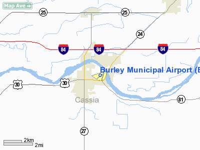
Burley Municipal Airport
Burley J R Jack Simplot Airport |
| IATA: BYI â ICAO: KBYI â FAA LID: BYI |
| Summary |
| Airport type |
Public |
| Owner |
City of Burley |
| Serves |
Burley, Idaho |
| Elevation AMSL |
4,150 ft / 1,265 m |
| Coordinates |
42°32â²33â³N 113°46â²18â³W / 42.5425°N 113.77167°W / 42.5425; -113.77167 |
| Website |
BurleyIdaho.org/airport.htm |
| Runways |
| Direction |
Length |
Surface |
| ft |
m |
| 2/20 |
4,094 |
1,248 |
Asphalt |
| 6/24 |
4,067 |
1,240 |
Asphalt |
| Statistics (2005) |
| Aircraft operations |
27,750 |
| Based aircraft |
56 |
| Sources: FAA, Burley website |
Burley Municipal Airport (IATA: BYI, ICAO: KBYI, FAA LID: BYI) is a city-owned public-use airport located one mile (2 km) northeast of the central business district of Burley, a city in Cassia County, Idaho, United States. The airport was rededicated as Burley J R Jack Simplot Airport in October 2002, honoring J. R. "Jack" Simplot.
Facilities and aircraft
Burley Municipal Airport covers an area of 201 acres (81 ha) which contains two asphalt paved runways: 2/20 measuring 4,094 x 80 ft (1,248 x 24 m) and 6/24 measuring 4,067 x 75 ft (1,240 x 23 m).
For the 12-month period ending February 10, 2005, the airport had 27,750 aircraft operations, an average of 76 per day: 98% general aviation, 1% air taxi and <1% military. There are 56 aircraft based at this airport: 84% single-engine, 10% multi-engine, 4% jet and 2% ultralight.
The above content comes from Wikipedia and is published under free licenses – click here to read more.
Location
& QuickFacts
|
FAA
Information Effective: |
2007-07-05 |
|
Airport
Identifier: |
BYI |
|
Airport
Status: |
Operational |
|
Longitude/Latitude: |
113-46-17.5590W/42-32-33.3730N
-113.771544/42.542604 (Estimated) |
|
Elevation: |
4150 ft / 1264.92 m (Surveyed) |
|
Land: |
201 acres |
|
From
nearest city: |
1 nautical miles NE of Burley, ID |
|
Location: |
Cassia County, ID |
|
Magnetic Variation: |
15E (2000) |
Owner
& Manager
|
Ownership: |
Publicly
owned |
|
Owner: |
City Of Burley |
|
Address: |
P.o. Box 1090
Burley, ID 83318 |
|
Phone
number: |
208-878-2224 |
|
Manager: |
Kevin Gebhart |
|
Address: |
P.o. Box 157
Burley, ID 83318 |
|
Phone number: |
208-678-0372 |
Airport Operations and Facilities
|
Airport
Use: |
Open
to public |
|
Wind
indicator: |
Yes |
|
Segmented Circle: |
No |
|
Control
Tower: |
No |
|
Lighting
Schedule: |
DUSK-DAWN
ACTVT MIRL RYS 02/20 & 06/24 - CTAF. VASI RYS 02, 20,
AND 24 OPR CONTINUOUSLY. |
|
Beacon
Color: |
Clear-Green (lighted land airport) |
|
Landing
fee charge: |
No |
|
Sectional chart: |
Salt Lake City |
|
Region: |
ANM - Northwest Mountain |
|
Boundary
ARTCC: |
ZLC - Salt Lake City |
|
Tie-in
FSS: |
BOI - Boise |
|
FSS
on Airport: |
No |
|
FSS
Phone: |
208-332-0200 |
|
FSS
Toll Free: |
1-800-WX-BRIEF |
|
NOTAMs
Facility: |
BYI (NOTAM-d service avaliable) |
|
Federal Agreements: |
NGY3 |
Airport Communications
Airport
Services
|
Fuel
available: |
100LLA |
|
Airframe
Repair: |
MAJOR |
|
Power
Plant Repair: |
MAJOR |
|
Bottled
Oxygen: |
LOW |
|
Bulk
Oxygen: |
NONE |
|
Runway Information
Runway 02/20
|
Dimension: |
4094
x 80 ft / 1247.9 x 24.4 m |
|
Surface: |
ASPH, Good Condition |
|
Weight
Limit: |
Single wheel: 12500 lbs.
Dual wheel: 12500 lbs. |
|
Edge
Lights: |
Medium |
|
|
Runway 02 |
Runway 20 |
|
Longitude: |
113-46-26.5791W |
113-45-53.3648W |
|
Latitude: |
42-32-15.5444N |
42-32-47.6620N |
|
Elevation: |
4150.00 ft |
4138.00 ft |
|
Alignment: |
37 |
127 |
|
Traffic
Pattern: |
Left |
Left |
|
Markings: |
Basic, Good Condition |
Non-precision instrument, Good Condition |
|
Crossing
Height: |
40.00 ft |
24.00 ft |
|
Displaced
threshold: |
620.00 ft |
300.00 ft |
|
VASI: |
4-box on left side |
2-box on right side |
|
Visual
Glide Angle: |
3.50° |
3.00° |
|
Runway
End Identifier: |
|
Yes |
|
Obstruction: |
20 ft road, 200.0 ft from runway
27' RR 620'; 190'R FM DSPLCD THR 22:1.
27' RR 0' FM THR 190' R; +15' RR SIGNAL 60' FM THR AND 160'
R. |
133 ft bldg, 4500.0 ft from runway, 200 ft
left of centerline, 32:1 slope to clear
APCH SLOPE 36:1 TO DSPLCD THR. |
|
Runway 06/24
|
Dimension: |
4067
x 75 ft / 1239.6 x 22.9 m |
|
Surface: |
ASPH, Good Condition |
|
Weight
Limit: |
Single wheel: 23000 lbs. |
|
Edge
Lights: |
Medium |
|
|
Runway 06 |
Runway 24 |
|
Longitude: |
113-46-51.7954W |
113-45-58.5039W |
|
Latitude: |
42-32-31.2865N |
42-32-39.0721N |
|
Elevation: |
4150.00 ft |
4140.00 ft |
|
Alignment: |
79 |
127 |
|
Traffic
Pattern: |
Left |
Left |
|
Markings: |
Basic, Good Condition |
Basic, Good Condition |
|
Crossing
Height: |
0.00 ft |
47.00 ft |
|
Displaced
threshold: |
410.00 ft |
0.00 ft |
|
VASI: |
|
2-box on right side |
|
Visual
Glide Angle: |
0.00° |
3.00° |
|
Obstruction: |
27 ft rr, 200.0 ft from runway, 35 ft left
of centerline
27' RR 800'; 120'R FM DSPLCD THR 29:1.
27' RR 175' ON CNTRLN; +8' FENCE 0' FM THR 80' R. |
32 ft poles, 1012.0 ft from runway, 25:1 slope
to clear |
|
Radio Navigation
Aids
|
ID |
Type |
Name |
Ch |
Freq |
Var |
Dist |
|
HDG |
NDB |
Steelhead |
|
211.00 |
16E |
45.8 nm |
|
BYI |
VOR/DME |
Burley |
088X |
114.10 |
18E |
4.7 nm |
|
TWF |
VORTAC |
Twin Falls |
105X |
115.80 |
18E |
32.0 nm |
Remarks
- BIRDS
INVOF ALL RWYS; ESPECIALLY AER 20 & AER 24.
- RY
02 & 06; NUMEROUS CLOSE IN OBSTRUCTIONS. RR BOX CARS MAY BE PARKED
ON TRACKS OFF END OF RY 02 & 06.
- MKD
HELIPAD ON RAMP IN FRONT OF WX OBESERVATION BLDG.
- AGRICULTURAL
ACTIVITY BETWEEN RWY & TXWY, APRIL-OCTOBER.
- ESTABD
PRIOR TO 15 MAY 1959.
Based
Aircraft
|
Aircraft
based on field: |
56 |
|
Single
Engine Airplanes: |
47 |
|
Multi
Engine Airplanes: |
6 |
|
Jet
Engine Airplanes: |
2 |
|
Ultralights: |
1 |
Operational Statistics
Time Period: 2004-02-12
- 2005-02-10
|
Aircraft
Operations: |
77/Day |
|
Air
Taxi: |
1.3% |
|
General
Aviation Local: |
26.3% |
|
General
Aviation Itinerant: |
72.1% |
|
Military: |
0.4% |
Burley Municipal Airport
Address:
Cassia County, ID
Tel:
208-878-2224,
208-678-0372
Images
and information placed above are from
http://www.airport-data.com/airport/BYI/
We
thank them for the data!
| General
Info |
| Country |
United
States |
| State |
IDAHO
|
| FAA ID |
BYI |
| Latitude |
42-32-33.373N
|
| Longitude |
113-46-17.559W
|
| Elevation |
4150 feet
|
| Near City |
BURLEY
|
We don't guarantee the information is fresh and accurate. The data may
be wrong or outdated.
For more up-to-date information please refer to other sources.
|
|


