 |
|
|
|
|
|
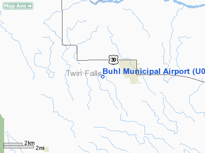
Location
& QuickFacts
|
FAA
Information Effective: |
2007-07-05 |
|
Airport
Identifier: |
U03 |
|
Airport
Status: |
Operational |
|
Longitude/Latitude: |
114-47-48.1840W/42-35-29.6570N
-114.796718/42.591571 (Estimated) |
|
Elevation: |
3660 ft / 1115.57 m (Surveyed) |
|
Land: |
104 acres |
|
From
nearest city: |
2 nautical miles W of Buhl, ID |
|
Location: |
Twin Falls County, ID |
|
Magnetic Variation: |
16E (1985) |
Owner & Manager
|
Ownership: |
Publicly owned |
|
Owner: |
City Of Buhl |
|
Address: |
203 North Broadway
Buhl, ID 83316 |
|
Phone number: |
208-543-5650 |
|
Manager: |
Bob Squire |
|
Address: |
Po Box 428
Buhl, ID 83316 |
|
Phone number: |
208-543-8803 |
Airport
Operations and Facilities
|
Airport
Use: |
Open
to public |
|
Wind
indicator: |
Yes |
|
Segmented Circle: |
Yes |
|
Control
Tower: |
No |
|
Lighting
Schedule: |
DUSK-DAWN
ACTVT LIRL RY 09/27 - CTAF. |
|
Beacon
Color: |
Clear-Green (lighted land airport) |
|
Landing
fee charge: |
No |
|
Sectional chart: |
Salt Lake City |
|
Region: |
ANM - Northwest Mountain |
|
Boundary
ARTCC: |
ZLC - Salt Lake City |
|
Tie-in
FSS: |
BOI - Boise |
|
FSS
on Airport: |
No |
|
FSS
Phone: |
208-332-0200 |
|
FSS
Toll Free: |
1-800-WX-BRIEF |
|
NOTAMs
Facility: |
BOI (NOTAM-d service avaliable) |
|
Federal Agreements: |
NGY |
Airport Communications
Airport
Services
|
Fuel
available: |
100LLMOGAS |
|
Airframe
Repair: |
MAJOR |
|
Power
Plant Repair: |
MAJOR |
|
Bottled
Oxygen: |
NONE |
|
Bulk
Oxygen: |
NONE |
|
Runway Information
Runway 09/27
|
Dimension: |
3900
x 60 ft / 1188.7 x 18.3 m |
|
Surface: |
ASPH, Good Condition |
|
Weight
Limit: |
Single wheel: 12500 lbs. |
|
Edge
Lights: |
Low |
|
|
Runway 09 |
Runway 27 |
|
Traffic
Pattern: |
Left |
Left |
|
Markings: |
Basic, Good Condition |
Basic, Good Condition |
|
Obstruction: |
30 ft pline, 1190.0 ft from runway, 210 ft
left of centerline, 33:1 slope to clear |
30 ft hill, 700.0 ft from runway, 150 ft left
of centerline, 16:1 slope to clear |
|
Radio Navigation
Aids
|
ID |
Type |
Name |
Ch |
Freq |
Var |
Dist |
|
HDG |
NDB |
Steelhead |
|
211.00 |
16E |
20.2 nm |
|
STI |
NDB |
Sturgeon |
|
333.00 |
17E |
49.2 nm |
|
LIA |
VOR |
Liberator |
|
114.90 |
18E |
49.1 nm |
|
BYI |
VOR/DME |
Burley |
088X |
114.10 |
18E |
41.2 nm |
|
TWF |
VORTAC |
Twin Falls |
105X |
115.80 |
18E |
15.2 nm |
Remarks
- RETROREFLECTIVE
REFLECTORS ON PARALLEL TWY.
- ESTABD
PRIOR TO 1959.
Based
Aircraft
|
Aircraft
based on field: |
36 |
|
Single
Engine Airplanes: |
34 |
|
Ultralights: |
2 |
Operational Statistics
Time Period: 2005-03-29
- 2006-03-28
|
Aircraft
Operations: |
289/Week |
|
Air
Taxi: |
0.1% |
|
General
Aviation Local: |
20.0% |
|
General
Aviation Itinerant: |
79.9% |
Buhl Municipal Airport
Address:
Twin Falls County, ID
Tel:
208-543-5650, 208-543-8803
Images
and information placed above are from
http://www.airport-data.com/airport/U03/
We
thank them for the data!
| General
Info |
| Country |
United
States |
| State |
IDAHO
|
| FAA ID |
U03 |
| Latitude |
42-35-29.657N
|
| Longitude |
114-47-48.184W
|
| Elevation |
3660 feet
|
| Near City |
BUHL |
We don't guarantee the information is fresh and accurate. The data may
be wrong or outdated.
For more up-to-date information please refer to other sources.
|
|


