 |
|
| Brooks Seaplane Base |
| IATA: none – ICAO: none – FAA LID: S76 |
| Summary |
| Airport type |
Public |
| Owner |
City of Coeur d'Alene |
| Serves |
Coeur d'Alene, Idaho |
| Elevation AMSL |
2,125 ft / 648 m |
| Coordinates |
47°40′20″N 116°47′10″W / 47.67222°N 116.78611°W / 47.67222; -116.78611 |
| Runways |
| Direction |
Length |
Surface |
| ft |
m |
| 11/29 |
15,000 |
4,572 |
Water |
| 15/33 |
15,000 |
4,572 |
Water |
| Statistics (2006) |
| Aircraft operations |
2,900 |
| Source: Federal Aviation Administration |
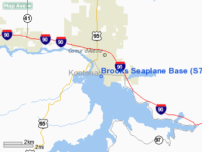
Brooks Seaplane Base (FAA LID: S76) is a city-owned, public-use seaplane base located in the city of Coeur d'Alene, Kootenai County, Idaho, United States. It is located on Lake Coeur d'Alene.
Facilities and aircraft
Brooks Seaplane Base has two landing areas designated 11/29 and 15/33, each measuring 15,000 x 2,000 feet (4,572 x 610 m). For the 12-month period ending September 27, 2006, the airport had 2,900 aircraft operations, an average of 242 per month: 59% general aviation and 41% air taxi.
The above content comes from Wikipedia and is published under free licenses – click here to read more.
Location
& QuickFacts
|
FAA
Information Effective: |
2007-07-05 |
|
Airport
Identifier: |
S76 |
|
Airport
Status: |
Operational |
|
Longitude/Latitude: |
116-47-09.6790W/47-40-19.6590N
-116.786022/47.672128 (Estimated) |
|
Elevation: |
2125 ft / 647.70 m (Surveyed) |
|
Land: |
0 acres |
|
From
nearest city: |
0 nautical miles SW of Coeur D'alene, ID |
|
Location: |
Kootenai County, ID |
|
Magnetic Variation: |
19E (1985) |
Owner
& Manager
|
Ownership: |
Publicly
owned |
|
Owner: |
City Of Coeur D'alene
DOCKS & OFFICE BLDG OWNED BY WILLIAM R BROOKS. |
|
Address: |
710 Mullan Ave
Coeur D'alene, ID 83814 |
|
Phone number: |
208-769-2300 |
|
Manager: |
W.r. Brooks |
|
Address: |
Box 1028
Coeur D'alene, ID 83814 |
|
Phone number: |
208-664-2842
AMGR HOME PHONE 208-772-5649. |
Airport
Operations and Facilities
|
Airport
Use: |
Open
to public |
|
Wind
indicator: |
Yes |
|
Segmented Circle: |
No |
|
Control
Tower: |
No |
|
Landing
fee charge: |
No |
|
Sectional chart: |
Great Falls |
|
Region: |
ANM - Northwest Mountain |
|
Boundary
ARTCC: |
ZSE - Seattle |
|
Tie-in
FSS: |
BOI - Boise |
|
FSS
on Airport: |
No |
|
FSS
Phone: |
208-332-0200 |
|
FSS
Toll Free: |
1-800-WX-BRIEF |
|
NOTAMs
Facility: |
BOI (NOTAM-d service avaliable) |
Airport Communications
Airport Services
|
Fuel
available: |
100LL |
|
Bottled
Oxygen: |
NONE |
|
Bulk
Oxygen: |
NONE |
|
Runway Information
Runway 11/29
|
Dimension: |
15000
x 2000 ft / 4572.0 x 609.6 m |
|
Surface: |
WATER, |
|
|
Runway 11 |
Runway 29 |
|
Elevation: |
2125.00 ft |
2125.00 ft |
|
Traffic
Pattern: |
Right |
Left |
|
Runway 15/33
|
Dimension: |
15000
x 2000 ft / 4572.0 x 609.6 m |
|
Surface: |
WATER, |
|
|
Runway 15 |
Runway 33 |
|
Elevation: |
2125.00 ft |
2125.00 ft |
|
Traffic
Pattern: |
Right |
Left |
|
Radio Navigation
Aids
|
ID |
Type |
Name |
Ch |
Freq |
Var |
Dist |
|
SFF |
NDB |
Felts |
|
365.00 |
19E |
21.3 nm |
|
DPY |
NDB |
Deer Park |
|
216.00 |
19E |
31.4 nm |
|
SZT |
NDB |
Sandpoe |
|
264.00 |
20E |
38.2 nm |
|
SKA |
TACAN |
Fairchild |
051X |
|
19E |
35.7 nm |
|
COE |
VOR/DME |
Coeur D'alene |
025X |
108.80 |
19E |
6.3 nm |
|
MLP |
VOR/DME |
Mullan Pass |
125X |
117.80 |
20E |
48.0 nm |
|
GEG |
VORTAC |
Spokane |
102X |
115.50 |
21E |
34.7 nm |
|
SFF |
VOT |
Spokane/felts Field |
|
114.00 |
|
21.6 nm |
|
GEG |
VOT |
Spokane Intl |
|
109.60 |
|
30.7 nm |
Remarks
- HEAVY
BOAT TFC & PARASAIL ACTIVITY ON & INVOF OF SPB LNDG AREA.
- FLY
PATTERNS OVER LAKE; DO NOT OVERLFLY CITY.
- HELICOPTER
OPNS INVOF SPB; HELIPAD LOCATION ON ADJ HOTEL ROOFTOP.
- ULTRALGT
ACFT OPERATE INVOF SPB LANDING AREA.
- ARPT
EXISTED PRIOR TO 15 MAY 1959.
Based
Aircraft
|
Aircraft
based on field: |
2 |
|
Single
Engine Airplanes: |
2 |
Operational Statistics
Time Period: 2005-09-28
- 2006-09-27
|
Aircraft
Operations: |
56/Week |
|
Air
Taxi: |
41.4% |
|
General
Aviation Local: |
41.4% |
|
General
Aviation Itinerant: |
17.2% |
Brooks Seaplane Base
Address:
Kootenai County, ID
Tel:
208-769-2300, 208-664-2842
Images
and information placed above are from
http://www.airport-data.com/airport/S76/
We
thank them for the data!
| General
Info |
| Country |
United
States |
| State |
IDAHO
|
| FAA ID |
S76 |
| Latitude |
47-40-19.659N
|
| Longitude |
116-47-09.679W
|
| Elevation |
2125 feet
|
| Near City |
COEUR
D'ALENE |
We don't guarantee the information is fresh and accurate. The data may
be wrong or outdated.
For more up-to-date information please refer to other sources.
|
|


