|
 |
|
||||
|
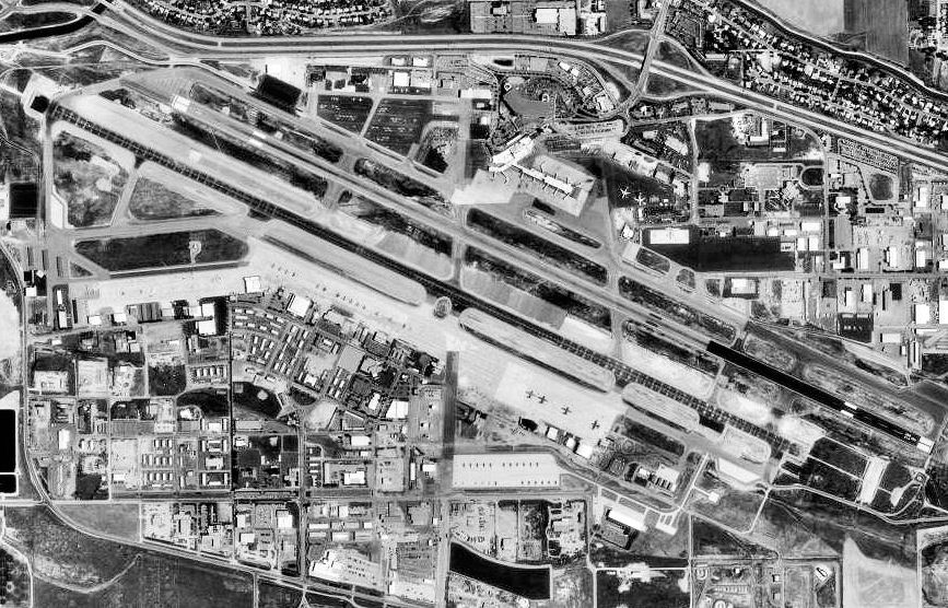
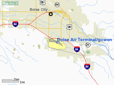
Boise Airport (IATA: BOI, ICAO: KBOI, FAA LID: BOI), also known as Boise Air Terminal or Gowen Field, is a joint civil-military, commercial and general aviation airport located three nautical miles (6 km) south of downtown Boise in Ada County, Idaho, USA. The airport is operated by the city of Boise Department of Aviation and is overseen by an Airport Commission. Boise is a landing rights airfield requiring international general aviation flights to receive permission from a Customs and Border Protection officer before landing on the field. In addition to being a commercial and general aviation airport, Boise also sees usage by the Idaho Air National Guard on the Gowen Field Air National Guard Base portion of the airport. The National Interagency Fire Center is based in the city of Boise and the Boise Airport is used for logistical support. The United States Forest Service also uses Boise Airport as a base for aerial firefighting air tankers during the wildfire season. 3,185,006 passengers transited Boise Airport in 2008, a 5% decrease over 2007 year's total, ranking 75th among US airports in total passengers. HistoryIn 1926, the first municipal airport in Boise was built on a gravel bed where the Boise State University campus now stands. The first commercial airmail flight in the United States passed through this airfield on April 26, 1926, carried by Varney Airlines. Varney Airlines began operating out of Boise in 1933, later merging with National Air Transport to become United Airlines. With United Airlines able to trace its roots to Varney, United is recognized as the airline that has operated the longest out of Boise, 83 years as of 2009. This airfield also played host to Charles Lindbergh's Spirit of St. Louis on September 4, 1927. The current airport has its origins in 1936 when Boise began buying and leasing land for the airport. By 1938, Boise had the longest runway in the United States at that time, 8,800 feet (2,680 m). The steel hangar for Varney Airlines was moved to the present field in 1939. As the size of aircraft grew, the hangar was no longer able to hold aircraft and was converted into a passenger terminal. It was part of the modern terminal facility until the completion of a new terminal in 2004. During World War II, the Army Air Corps, later Army Air Forces, leased the field for use a training base for B-17 Flying Fortress and B-24 Liberator bomber crews. More than 6,000 men were stationed there during the war. The field was named Gowen Field on July 23, 1941 after 1st Lt Paul R. Gowen (1909â1938), who was born and raised in Caldwell, attended the University of Idaho, and graduated ninth in his class at West Point in 1933. Gowen was killed instantly in a crash in Panama in July 1938 while piloting a twin-engine B-10 bomber for the Army Air Corps. The right engine failed shortly after take-off from Albrook Field, near Panama City. The other two crew members, navigator and radio operator, survived and crawled from the wreckage with burns. After the war, the portion of the field used by the Army Air Forces was returned to the city. The Idaho Air National Guard began leasing the airfield after the war and continues to lease it currently. Between 2003 and 2005, the Boise Airport was remodeled. The airport now features a brand new terminal and an elevated roadway for departures.
The Boise Airport Passenger Terminal designed by CSHQA is a three-story, steel-framed 378,000-square-foot (35,100 m) state-of-the-art aviation facility. Curvilinear, steel trusses create the undulating ceiling plane of the ticket lobby and define the signature profile of the building. The terminal has garnered national attention for the beauty of its design and is considered a prototypical post 9/11 facility. The Boise Airport was ranked fourth in passenger satisfaction in the J.D. Power and Associates 2004 Global Airport Satisfaction Index Study. The Boise Airport was a hub for Horizon Air from the late 1980s to the early 2000s with over 50 flights to 15 destinations at its peak, but was scaled down post 9/11. It currently serves as a minor focus city. FacilitiesBoise Airport covers an area of 5,000 acres (2,023 ha) at an elevation of 2,871 feet (875 m) above mean sea level. It has two runways:
For the 12-month period ending April 30, 2007, the airport had 184,023 aircraft operations, an average of 504 per day: 52% general aviation, 23% scheduled commercial, 18% air taxi, 7% military. At that time there were 286 aircraft based at this airport: 58% single-engine, 10% multi-engine, 7% jet, 9% helicopter and 16% military. In 2005, over 3 million passengers passed through the Boise airport. The airport can handle minor maintenance and repairs through fixed base operators Jackson Jet Center, Turbo Air and Western Aircraft.
Law enforcement at the airport is handled by the Boise Police Department. The Airport Division has an authorized strength of 1 lieutenant, 2 sergeants, and 28 officers. There are currently 5 TSA certified K-9 units trained in explosive detection. New ATC TowerOn January 4, 2008, city officials broke ground for Boise Air Terminal's latest improvement, a new air traffic control tower. As of today the tower is complete and stands 295 feet (90 m) tall, being Idaho's tallest structure and the Pacific Northwest's tallest control tower. It has also been relocated to the south side of the airport in order to control an existing Guard assault strip and a possible new runway south of Gowen Field. The tower will not be in operation for possibly several years however, as the city is waiting for more advanced controlling equipment. Gowen Field Air National Guard BaseGowen Field ANGB primarily refers to the military facilities on the south side of the runways, which includes Air National Guard, Army National Guard, and reserve units of the Army, Navy, and Marine Corps. The field is home to the 124th Wing (124 WG), Idaho Air National Guard, which is made up of two flying squadrons operationally-gained by the Air Combat Command (ACC) and Air Mobility Command (AMC), respectively, and 12 additional support units. The aircraft based at Gowen Field ANGB are the A-10 Thunderbolt II close air support attack aircraft of the 190th Fighter Squadron (190 FS) and C-130 Hercules transport aircraft of the 189th Airlift Squadron (189 AS). The 124 WG is composed of over 1000 military personnel, ranging from full-time Active Guard and Reserve (AGR) and Air Reserve Technicians (ART) to traditional part-time air national guardsmen. Airlines and destinationsA number of scheduled airline flights pass through Boise. In addition to airlines, there are several charter companies that operate out of Boise.
Accidents and incidents
The above content comes from Wikipedia and is published under free licenses – click here to read more.
Runway InformationRunway 10L/28R
Runway 10R/28L
Radio Navigation Aids
Remarks
Based Aircraft
Major Carriers Serving This Airport
Most Popular Destinations
Most Popular Aircraft
Operational StatisticsTime Period: 2005-05-02 - 2006-05-01
Boise Air Terminal/gowen Field Airport Address: Ada County, ID Tel: 208-383-3110 Images
and information placed above are from We thank them for the data!
We don't guarantee the information is fresh and accurate. The data may
be wrong or outdated.
|
|||||||||||||||||||||||||||||||||||||||||||||||||||||||||||||||||||||||||||||||||||||||||||||||||||||||||||||||||||||||||||||||||||||||||||||||||||||||||||||||||||||||||||||||||||||||||||||||||||||||||||||||||||||||||||||||||||||||||||||||||||||||||||||||||||||||||||||||||||||||||||||||||||||||||||||||||||||||||||||||||||||||||||||||||||||||||||||||||||||||||||||||||||||||||||||||||||||||||||||||||||||||||||||||||||||||||||||||||||||||||||||||||||||||||||||||||||||||||||||||||||||||||||||||||||||||||||||

 |
|
Copyright 2004-2024 © by Airports-Worldwide.com, Vyshenskoho st. 36, Lviv 79010, Ukraine Legal Disclaimer |