 |
|
|
|
|
|
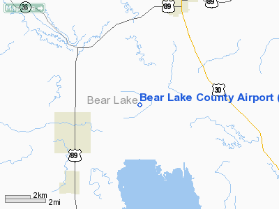
Location
& QuickFacts
|
FAA
Information Effective: |
2007-07-05 |
|
Airport
Identifier: |
1U7 |
|
Airport
Status: |
Operational |
|
Longitude/Latitude: |
111-20-17.7360W/42-14-49.7390N
-111.338260/42.247150 (Estimated) |
|
Elevation: |
5928 ft / 1806.85 m (Estimated) |
|
Land: |
1180 acres |
|
From
nearest city: |
3 nautical miles E of Paris, ID |
|
Location: |
Bear Lake County, ID |
|
Magnetic Variation: |
15E (1985) |
Owner
& Manager
|
Ownership: |
Publicly
owned |
|
Owner: |
Bear Lake County |
|
Address: |
Po Box 190
Paris, ID 83261 |
|
Phone
number: |
208-945-2212 |
|
Manager: |
Ob & Mary Toomer |
|
Address: |
P O Box 163
Montpelier, ID 83254 |
|
Phone number: |
208-847-1374 |
Airport Operations and Facilities
|
Airport
Use: |
Open
to public |
|
Wind
indicator: |
Yes |
|
Segmented Circle: |
No |
|
Control
Tower: |
No |
|
Lighting
Schedule: |
DUSK-DAWN |
|
Beacon
Color: |
Clear-Green (lighted land airport) |
|
Landing
fee charge: |
No |
|
Sectional chart: |
Salt Lake City |
|
Region: |
ANM - Northwest Mountain |
|
Boundary
ARTCC: |
ZLC - Salt Lake City |
|
Tie-in
FSS: |
BOI - Boise |
|
FSS
on Airport: |
No |
|
FSS
Phone: |
208-332-0200 |
|
FSS
Toll Free: |
1-800-WX-BRIEF |
|
NOTAMs
Facility: |
BOI (NOTAM-d service avaliable) |
|
Federal Agreements: |
NGY3 |
Airport Communications
|
CTAF: |
122.800 |
|
Unicom: |
122.800
|
Airport
Services
|
Fuel
available: |
100LL |
|
Airframe
Repair: |
NONE |
|
Power
Plant Repair: |
NONE |
|
Bottled
Oxygen: |
NONE |
|
Bulk
Oxygen: |
NONE |
|
Runway Information
Runway 10/28
|
Dimension: |
5730
x 75 ft / 1746.5 x 22.9 m |
|
Surface: |
ASPH, Good Condition |
|
Weight
Limit: |
Single wheel: 12500 lbs. |
|
Edge
Lights: |
Medium
RY 10/28 NSTD MIRL MOUNTED APRX 40 INCH ABOVE GND, 10' FM EDGE OF
PAVEMENT. |
|
|
Runway 10 |
Runway 28 |
|
Traffic
Pattern: |
Left |
Left |
|
Markings: |
Basic, Good Condition |
Basic, Good Condition |
|
Obstruction: |
60 ft pline, 2500.0 ft from runway, 38:1 slope
to clear |
12 ft road, 500.0 ft from runway, 25:1 slope
to clear |
|
Runway 16/34
|
Dimension: |
4590
x 70 ft / 1399.0 x 21.3 m |
|
Surface: |
ASPH, Good Condition |
|
Weight
Limit: |
Single wheel: 50000 lbs.
Dual wheel: 64000 lbs.
Dual tandem wheel: 102000 lbs. |
|
|
Runway 16 |
Runway 34 |
|
Longitude: |
111-20-48.6400W |
111-20-42.7913W |
|
Latitude: |
42-15-14.6600N |
42-14-29.5260N |
|
Elevation: |
5927.00 ft |
5926.00 ft |
|
Traffic
Pattern: |
Left |
Left |
|
Markings: |
Basic, Good Condition
RUNWAY 16/34 HAS RUNWAY SIDE STRIPE MARKING |
Basic, Good Condition |
|
Obstruction: |
19 ft road, 1000.0 ft from runway, 42:1 slope
to clear |
40 ft trees, 1000.0 ft from runway, 150 ft
right of centerline, 20:1 slope to clear |
|
Radio Navigation
Aids
|
ID |
Type |
Name |
Ch |
Freq |
Var |
Dist |
|
LGU |
VOR/DME |
Logan |
035X |
109.80 |
16E |
33.8 nm |
|
LHO |
VOR/DME |
Brigham City |
076X |
112.90 |
14E |
40.6 nm |
|
MLD |
VOR/DME |
Malad City |
121X |
117.40 |
17E |
49.6 nm |
Remarks
- BIRDS
ON & INVOF OF ARPT.
- REFLECTORS
ON TAXIWAY AND RAMP
- TAXIWAY
IS 40' WIDE.
- RADIO
CTLD MODEL ACFT ARE FLOWN FM DEP END RY 34.
- ESTABD
PRIOR TO 15 MAY 1959.
Based Aircraft
|
Aircraft
based on field: |
5 |
|
Single
Engine Airplanes: |
5 |
Operational Statistics
Time Period: 2003-05-08
- 2004-05-06
|
Aircraft
Operations: |
85/Week |
|
General
Aviation Local: |
9.1% |
|
General
Aviation Itinerant: |
90.9% |
Bear Lake County Airport
Address:
Bear Lake County, ID
Tel:
208-945-2212,
208-847-1374
Images
and information placed above are from
http://www.airport-data.com/airport/1U7/
We
thank them for the data!
| General
Info |
| Country |
United
States |
| State |
IDAHO
|
| FAA ID |
1U7 |
| Latitude |
42-14-49.739N
|
| Longitude |
111-20-17.736W
|
| Elevation |
5928 feet
|
| Near City |
PARIS
|
We don't guarantee the information is fresh and accurate. The data may
be wrong or outdated.
For more up-to-date information please refer to other sources.
|
|


