 |
|
| Atlanta Airport |
| IATA: none – ICAO: none – FAA LID: 55H |
| Summary |
| Airport type |
Public |
| Owner |
State of Idaho - ITD Division of Aeronautics |
| Serves |
Atlanta, Idaho |
| Elevation AMSL |
5,500 ft / 1,676 m |
| Coordinates |
43°48′49″N 115°08′06″W / 43.81361°N 115.135°W / 43.81361; -115.135 |
| Runways |
| Direction |
Length |
Surface |
| ft |
m |
| 16/34 |
2,460 |
750 |
Turf/Dirt |
| Statistics (2005) |
| Aircraft operations |
900 |
| Source: Federal Aviation Administration |
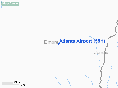
Atlanta Airport (FAA LID: 55H) is a public airport located one mile (2 km) northwest of the central business district of Atlanta, a town in Elmore County, Idaho, United States. It is owned by the State of Idaho, Idaho Transportation Department, Division of Aeronautics.
Facilities and aircraft
Atlanta Airport covers an area of 14 acres (6 ha) and had one runway designated 16/34 with a 2,460 by 75 ft (750 by 23 m) turf/dirt surface. For the 12-month period ending July 29, 2005, the airport had 900 aircraft operations, an average of 75 per month: 89% general aviation and 11% air taxi.
The above content comes from Wikipedia and is published under free licenses – click here to read more.
Location
& QuickFacts
|
FAA
Information Effective: |
2007-07-05 |
|
Airport
Identifier: |
55H |
|
Airport
Status: |
Operational |
|
Longitude/Latitude: |
115-08-06.2940W/43-48-48.6390N
-115.135082/43.813511 (Estimated) |
|
Elevation: |
5500 ft / 1676.40 m (Surveyed) |
|
Land: |
14 acres |
|
From
nearest city: |
1 nautical miles NW of Atlanta, ID |
|
Location: |
Elmore County, ID |
|
Magnetic Variation: |
17E (1985) |
Owner
& Manager
|
Ownership: |
Publicly
owned |
|
Owner: |
State Of Id Itd Div Aero |
|
Address: |
Box 7129
Boise, ID 83707-1129 |
|
Phone number: |
208-334-8775 |
|
Manager: |
Division Admin |
|
Address: |
Box 7129
Boise, ID 83707-1129 |
|
Phone number: |
208-334-8775 |
Airport
Operations and Facilities
|
Airport
Use: |
Open
to public |
|
Wind
indicator: |
Yes |
|
Segmented Circle: |
Yes |
|
Control
Tower: |
No |
|
Landing
fee charge: |
No |
|
Sectional chart: |
Salt Lake City |
|
Region: |
ANM - Northwest Mountain |
|
Boundary
ARTCC: |
ZLC - Salt Lake City |
|
Tie-in
FSS: |
BOI - Boise |
|
FSS
on Airport: |
No |
|
FSS
Phone: |
208-332-0200 |
|
FSS
Toll Free: |
1-800-WX-BRIEF |
|
NOTAMs
Facility: |
BOI (NOTAM-d service avaliable) |
Airport Communications
Airport Services
|
Airframe
Repair: |
NONE |
|
Power
Plant Repair: |
NONE |
|
Bottled
Oxygen: |
NONE |
|
Bulk
Oxygen: |
NONE |
|
Runway Information
Runway 16/34
|
Dimension: |
2460
x 75 ft / 749.8 x 22.9 m |
|
Surface: |
TURF-DIRT, Good Condition |
|
|
Runway 16 |
Runway 34 |
|
Traffic
Pattern: |
Left |
Right |
|
Obstruction: |
50 ft tree, 75 ft right of centerline |
45 ft trees, 0.0 ft from runway, 100L/ ft right
of centerline |
|
Radio Navigation
Aids
|
ID |
Type |
Name |
Ch |
Freq |
Var |
Dist |
|
STI |
NDB |
Sturgeon |
|
333.00 |
17E |
47.9 nm |
|
HLE |
NDB/DME |
Hailey |
025X |
220.00 |
16E |
48.6 nm |
|
BOI |
VORTAC |
Boise |
080X |
113.30 |
17E |
48.5 nm |
|
BOI |
VOT |
Boise |
|
116.70 |
|
49.8 nm |
Remarks
- RECOMMENDED
FOR USE BY MOUNTAIN PROFICIENT PILOTS USING HIGH PERFORMANCE AIRCRAFT.
ARPT IS LOCATED IN MOUNTAINOUS AREA; HIGH TIMBERED RIDGES LIMIT MANEUVERING
AREA. LAND RY 34, DEPART RY 16. APPROACH UP BOISE RIVER MAKING RIGHT
CIRCLING PATTERN OVER VALLEY TO CHECK TRAFFIC AT GREENE ARPT.
- DEPART
WITH A RIGHT TURNOUT DOWN BOISE RIVER. ANNOUNCE INTENTIONS ON 122.9.
NO GO-AROUND DUE TO RISING TERRAIN AND TREES.
- NO
WINTER MAINT.
- GROUND
VEHICLE TRAFFIC HAS ACCESS TO RY.
- NO
TELEPHONE AVBL AT ARPT.
- (E111-1)
SIGNS ARE POSTED AT BOTH ARPTS WHICH ADVISE PILOTS OF THE COMMUNICATIONS
REQUIRED TO ASSURE THE COMPATIBLE OPERATION OF BOTH AIRPORTS.
- PROVIDED
ARRIVAL/DEPARTURE PROCEDURES, INCLUDING RECOMMENDED COMMUNICATIONS PROCEDURES,
AS SPECIFIED IN THE GREENE/COOKE AGREEMENT BE PUBLISHED IN THE IDAHO
AIRPORT DIRECTORY; A WARNING NOTE ABOUT THE CLOSE PROXIMITY OF THE TWO
AIRPORTS SHOULD BE PUBLISHED.
Operational
Statistics
Time Period: 2004-07-30
- 2005-07-29
|
Aircraft
Operations: |
18/Week |
|
Air
Taxi: |
11.1% |
|
General
Aviation Itinerant: |
88.9% |
Atlanta Airport
Address:
Elmore County, ID
Tel:
208-334-8775
Images
and information placed above are from
http://www.airport-data.com/airport/55H/
We
thank them for the data!
| General
Info |
| Country |
United
States |
| State |
IDAHO
|
| FAA ID |
55H |
| Latitude |
43-48-48.639N
|
| Longitude |
115-08-06.294W
|
| Elevation |
5500 feet
|
| Near City |
ATLANTA
|
We don't guarantee the information is fresh and accurate. The data may
be wrong or outdated.
For more up-to-date information please refer to other sources.
|
|


