 |
|
| Kapalua Airport |
 |
| IATA: JHM – ICAO: PHJH – FAA LID: JHM
Location of airport in Hawaii
|
| Summary |
| Airport type |
Public |
| Operator |
Hawaii Department of Transportation |
| Serves |
Lahaina, Hawaii |
| Location |
Kapalua, Hawaii |
| Elevation AMSL |
256 ft / 78 m |
| Coordinates |
20°57′47″N 156°40′23″W / 20.96306°N 156.67306°W / 20.96306; -156.67306 (Kapalua Airport)Coordinates: 20°57′47″N 156°40′23″W / 20.96306°N 156.67306°W / 20.96306; -156.67306 (Kapalua Airport) |
| Website |
hawaii.gov/jhm |
| Runways |
| Direction |
Length |
Surface |
| ft |
m |
| 2/20 |
3,000 |
914 |
Asphalt |
| Statistics (2004) |
| Aircraft operations |
9,990 |
| Source: Federal Aviation Administration |
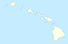
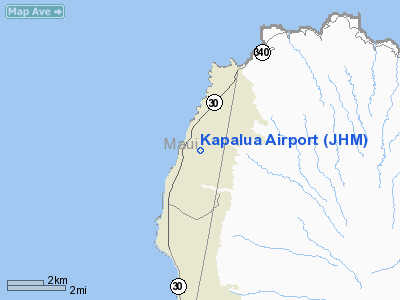
Kapalua Airport (IATA: JHM, ICAO: PHJH, FAA LID: JHM), also known as Kapalua West Maui Airport, is a regional airport on the west side of the island of Maui. It is located 5 NM (9.3 km; 5.8 mi) northwest of Lahaina, in Maui County, Hawaii, United States.
Most flights to Kapalua Airport originate from commuter airports on the other Hawaiian islands by commercial commuter services (Island Air), unscheduled air taxis, and general aviation. The airport code name JHM stands for John Henry Magoon, who was president of Hawaiian Airlines when that airline developed the airport. Facilities and aircraft
Kapalua Airport is governed by a special agreement made by the state with Maui County. A former, privately owned airport, major changes or improvements to Kapalua Airport cannot be made without the consent of the Maui County Council. The county insists on limiting development to preserve the Kapalua community from commercialization. Kapalua Airport is restricted to a single runway, a couple of terminal facilities and support facilities. There are no air cargo facilities. Operations are restricted to daytime hours only.
JTB Hawaii, an affiliate company of Japanese travel agent JTB Corporation, operates its customer service outlet located in the lobby.
The airport covers an area of 50 acres (20 ha) at an elevation of 256 feet (78 m) above mean sea level. It has one runway designated 2/20 with an asphalt surface measuring 3,000 by 100 feet (914 x 30 m). For the 12-month period ending December 31, 2004, the airport had 9,990 aircraft operations, an average of 27 per day: 51% scheduled commercial and 49% air taxi.
Airlines and destinations
| Airlines |
Destinations |
| Island Air |
Honolulu, Molokai |
Authority
Kapalua Airport is part of a centralized state structure governing all of the airports and seaports of Hawai'i. The official authority of Kapalua Airport is the Governor of Hawai'i. He or she appoints the Director of the Hawai'i State Department of Transportation who has jurisdiction over the Hawai'i Airports Administrator.
The Hawai'i Airports Administrator oversees six governing bodies: Airports Operations Office, Airports Planning Office, Engineering Branch, Information Technology Office, Staff Services Office, Visitor Information Program Office. Collectively, the six bodies have authority over the four airport districts in Hawai'i: Hawai'i District, Kaua'i District, Maui District and the principal O'ahu District. Kapalua Airport is a subordinate of the Maui District officials.
The above content comes from Wikipedia and is published under free licenses – click here to read more.
Location
& QuickFacts
|
FAA
Information Effective: |
2007-07-05 |
|
Airport
Identifier: |
JHM |
|
Airport
Status: |
Operational |
|
Longitude/Latitude: |
156-40-22.9140W/20-57-46.5710N
-156.673032/20.962936 (Estimated) |
|
Elevation: |
256 ft / 78.03 m (Surveyed) |
|
Land: |
50 acres |
|
From
nearest city: |
5 nautical miles NW of Lahaina, HI |
|
Location: |
Maui County, HI |
|
Magnetic Variation: |
11E (1990) |
Owner
& Manager
Islands of Maui, Molokai & Lanai
District Manager, Kahului Airport
1 Kahului Airport Road, Unit 5
Kahului, HI 96732-2327
(808) 872-3808
fax - (808) 872-3829
Airport
Operations and Facilities
|
Airport
Use: |
Private |
|
Wind
indicator: |
Yes |
|
Segmented Circle: |
Yes |
|
Control
Tower: |
No |
|
Sectional chart: |
Hawaiian Islands |
|
Region: |
AWP - Western-Pacific |
|
Boundary
ARTCC: |
ZHN - Honolulu Control Facility |
|
Tie-in
FSS: |
HNL - Honolulu |
|
FSS
Phone: |
808-836-8049 |
|
FSS
Toll Free: |
1-800-WX-BRIEF |
|
Certification type/date: |
I A S 02/1987
ARFF HRS: 0615-1815 |
|
Federal Agreements: |
N |
Airport Communications
|
CTAF: |
122.700 |
|
Unicom: |
122.700
UNICOM OPN 0600-1800 DAILY. TSNT ACFT MAL CALL FOR TFC ADVYS. |
|
Runway Information
Runway 02/20
|
Dimension: |
3000
x 100 ft / 914.4 x 30.5 m |
|
Surface: |
ASPH, Fair Condition |
|
Weight
Limit: |
Dual wheel: 44000 lbs. |
|
|
Runway 02 |
Runway 20 |
|
Longitude: |
156-40-30.3440W |
156-40-15.4840W |
|
Latitude: |
20-57-33.4440N |
20-57-59.6970N |
|
Elevation: |
241.00 ft |
256.00 ft |
|
Alignment: |
28 |
127 |
|
Traffic
Pattern: |
Left |
Right |
|
Markings: |
Non-precision instrument, Fair Condition |
|
Obstruction: |
, 50:1 slope to clear |
90 ft tree, 3500.0 ft from runway, 700 ft left
of centerline, 39:1 slope to clear |
|
Radio Navigation
Aids
|
ID |
Type |
Name |
Ch |
Freq |
Var |
Dist |
|
VYI |
NDB |
Valley Island |
|
327.00 |
11E |
13.8 nm |
|
LLD |
NDB |
Lanai |
|
353.00 |
11E |
20.4 nm |
|
OGG |
VORTAC |
Maui |
098X |
115.10 |
11E |
14.6 nm |
|
LNY |
VORTAC |
Lanai |
124X |
117.70 |
11E |
20.5 nm |
|
MKK |
VORTAC |
Molokai |
108X |
116.10 |
11E |
29.7 nm |
Remarks
- ARPT
RESTRICTED TO PART 121 & 135 FAR OPERATORS WITH PPR CTC KAHULUI
ARPT OPNS 808-872-3880 (24 HRS).
- NO
HELICOPTER OPNS PERMITTED.
- NO
JET POWERED ACFT ALLOWED.
- NO
PRACTICE & TRAINING FLTS PERMITTED.
- SPECIAL
NOISE LEVEL STANDARDS FOR ACFT OPER AT ARPT.
- RESTRICTION
ON NUMBER OF DAILY FLTS DEPENDING ON ACFT CAPACITY & SIZE.
- RAPIDLY
RISING TERRAIN UP TO 300 FT MSL ALONG THE FULL LENGTH OF RWY 02/20 APPROX
160 FT EAST OF CENTERLINE.
- VFR,PRIVATE
USE ONLY; TFC PTRNS ESTABLISHED TO AVOID CONFLICT WITH KAANOPALI ARPT.
Operational Statistics
Time Period: 2004-01-02 - 2004-12-31
|
Aircraft
Operations: |
193/Week |
|
Commerical: |
51.2% |
|
Air
Taxi: |
48.8% |
Kapalua Airport
Address:
Maui County, HI
Tel:
808-838-8701,
808-372-3830
Images
and information placed above are from
http://www.airport-data.com/airport/JHM/
We
thank them for the data!
| General
Info |
| Country |
United
States |
| State |
HAWAII
|
| FAA ID |
JHM |
| Latitude |
20-57-46.571N
|
| Longitude |
156-40-22.914W
|
| Elevation |
256 feet
|
| Near City |
LAHAINA
|
Thanks to: www.worldaerodata.com
We don't guarantee the information is fresh and accurate. The data may
be wrong or outdated.
For more up-to-date information please refer to other sources.
|
 |