|
 |
|
||||
|
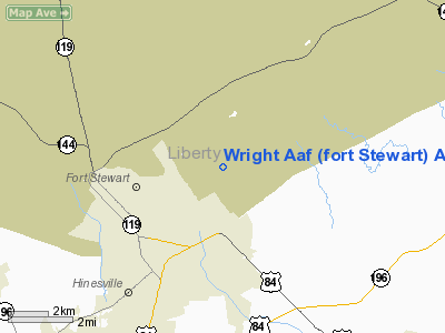
MidCoast Regional Airport at Wright Army Airfield (IATA: LIY, ICAO: KLHW, FAA LID: LHW) is a joint public and military use airport at Fort Stewart, a United States Army post located near the city of Hinesville in Liberty County, Georgia, United States. The airport's physical address is 1116 E. Lowe Circle, Fort Stewart, GA 31314 and its mailing address is P.O. Box 10, Hinesville, GA 31310. Wright Army Airfield became a joint-use facility in November 2007. The name MidCoast refers to its location on the Georgia coast between Savannah/Hilton Head International Airport and Brunswick Golden Isles Airport. The airport is managed by a Joint Management Board (JMB) consisting of the City of Hinesville, Liberty County (Board of Commissioners & Development Authority) and the U.S. Army. The JMB contracted with ABS Aviation Management Services to manage and operate the new facilities and the fixed base operator (FBO) for civilian operations. Although most U.S. airports use the same three-letter location identifier for the FAA and IATA, this airport is assigned LHW by the FAA and LIY by the IATA (which assigned LHW to Lanzhou, Gansu, China). HistoryIn early 1942, construction began on an airfield at Camp Stewart. Camp Stewart Army Airfield was also known as Liberty Airfield for its Georgia county location. The facility was quite small with two 5,000-ft. runways, approximately a dozen and a half hardstands, and barracks for 50 officers and 300 men. On 1 January 1943, the Air Technical Service Command 4th Tow Target Detachment moved to the newly completed airfield from Atlanta Army Airfield with a mission of towing aerial targets for anti-aircraft artillery training, with the airfield becoming a sub-base of Atlanta, with the 142d Army Air Force Base Unit being the host unit.. The Detachment's aircraft consisted of a mixture of aircraft, consisting of the Douglas A-20 Havoc, Beech C-43 Staggerwing, Taylorcraft L-2 Grasshopper, Beech AT-7, Douglas A-24 Dauntless, Curtiss A-25 Helldiver, and the B-34 Lexington. In October, 15 Women Army Service Pilots (WASP) began a 90-day course in the operation of radio controlled targets while piloting A-24 and A-25 aircraft.
The peak utilization of Stewart AAF took place in the spring of 1944, during the build up for the invasion of Europe when over 55,000 men were present. In addition to anti-aircraft artillery training, Stewart AAF also trained cooks and bakers as well as postal units. The camp also had a POW compound for Germans and Italians captured in North Africa. The POWs were put to work on the camp's construction projects and local farms. By the spring of 1945, the camp was virtually empty except for the POW compound. On March 25, 1945, the airfield deactivated and the Detachment transferred to Chatham AAF. Following the end of the war, the Army used Camp Stewart as a separation center for a short period of time before deactivating it on 30 September 1945. In the postwar years, the Army utilized the camp during the summer for the training of National Guard units. Camp Stewart re-opened during the Korean War for training of the 3rd Army's anti-aircraft artillery units. In 1953, the training of armor units was added. In 1959, the Army made the post a permanent United States Army facility, designated it as an Armor and Artillery Training Center, renaming it Fort Stewart. Camp Stewart Army Airfield was renamed Wright Army Airfield and used as a military airport within the Fort Stewart facility. During the Vietnam War, the airfield trained initial entry Army Fixed Wing Aviators and helicopter pilots. When the Air Force closed Hunter AFB in 1967, the Army took it over as a sub-base of Fort Stewart and established a Flight Training Center. With the end of the Vietnam War Fort Stewart became idle once again. That ended with the reactivation of the 24th Infantry Division at Stewart in 1974. In 1996, the 3rd Infantry Division activated and remains at Fort Stewart today, with Wright Army Airfield being an operational part of the facility.
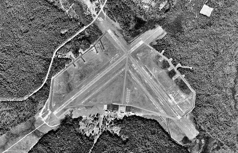
Facilities and aircraftThe airport covers an area of 429 acres (174 ha) at an elevation of 45 feet (14 m) above mean sea level. It has four asphalt paved runways: 6L/24R is 5,010 by 100 feet (1,527 x 30 m); 6R/24L is 2,605 by 100 feet (794 x 30 m); 15L/33R is 5,000 by 150 feet (1,524 x 46 m); 15R/33L is 2,518 by 100 feet (767 x 30 m) with an asphalt surface. A new 13,825-square-foot (1,284 m) terminal building contains a civilian fixed base operation (FBO) terminal and a military operations building which is leased to the Army Corps of Engineers. The airport has 12 T-hangars, 5 box hangars, and a 10,000-square-foot (929 m) bulk hangar with a 30-foot (9 m) door. The civilian general aviation part of the development also includes a large ramp, with plans for self-fueling and aircraft wash facilities. Over a 12-month period the airport had 5,600 aircraft operations, an average of 15 per day: 89% general aviation and 11% military. At that time there were 15 aircraft based at this airport: 86.7% single-engine, 6.7% multi-engine and 6.7% helicopter. The above content comes from Wikipedia and is published under free licenses – click here to read more.
Runway InformationRunway 06L/24R
Runway 06R/24L
Runway 15L/33R
Runway 15R/33L
Radio Navigation Aids
Remarks
Wright Aaf (fort Stewart) Airport Address: Liberty County, GA Tel: 912-767-4803 Images
and information placed above are from We thank them for the data!
We don't guarantee the information is fresh and accurate. The data may
be wrong or outdated.
|
||||||||||||||||||||||||||||||||||||||||||||||||||||||||||||||||||||||||||||||||||||||||||||||||||||||||||||||||||||||||||||||||||||||||||||||||||||||||||||||||||||||||||||||||||||||||||||||||||||||||||||||||||||||||||||||||||||||||||||||||||||||||||||||||||||||||||||||||||||||||||||||||||||||||||||||||||||||||||||||||||||||||||||||||||||||||||||||||||||||||||||

 |
|
|