 |
|
|
 |
(Click on the photo to enlarge) |
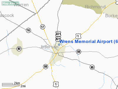
Location
& QuickFacts
|
FAA Information Effective: |
2007-07-05 |
|
Airport
Identifier: |
65J |
|
Airport
Status: |
Operational |
|
Longitude/Latitude: |
082-23-01.4500W/33-13-21.5220N
-82.383736/33.222645 (Estimated) |
|
Elevation: |
450 ft / 137.16 m (Estimated) |
|
Land: |
68 acres |
|
From
nearest city: |
1 nautical miles N of Wrens, GA |
|
Location: |
Jefferson County, GA |
|
Magnetic Variation: |
03W (1985) |
Owner
& Manager
|
Ownership: |
Publicly owned |
|
Owner: |
City Of Wrens |
|
Address: |
City Hall, Po Box 125
Wrens, GA 30833 |
|
Phone
number: |
706-547-3000 |
|
Manager: |
Donna Scott Johnson, City Administr |
|
Address: |
City Hall, Po Box 125
Wrens, GA 30833 |
|
Phone number: |
706-547-3000 |
Airport
Operations and Facilities
|
Airport Use: |
Open to public |
|
Wind
indicator: |
Yes |
|
Segmented
Circle: |
Yes |
|
Control
Tower: |
No |
|
Lighting
Schedule: |
DUSK-DAWN
ACTVT MIRL RY 11/29 - CTAF. |
|
Beacon
Color: |
Clear-Green (lighted land airport)
ROTG BCN OTS INDEFLY. |
|
Landing
fee charge: |
No |
|
Sectional
chart: |
Atlanta |
|
Region: |
ASO - Southern |
|
Boundary
ARTCC: |
ZTL - Atlanta |
|
Tie-in
FSS: |
MCN - Macon |
|
FSS
on Airport: |
No |
|
FSS
Toll Free: |
1-800-WX-BRIEF |
|
NOTAMs
Facility: |
MCN (NOTAM-d service avaliable) |
|
Federal Agreements: |
NY1 |
Airport
Communications
|
CTAF: |
122.700 |
|
Unicom: |
122.700 |
Airport
Services
|
Bottled
Oxygen: |
NONE |
|
Bulk
Oxygen: |
NONE |
|
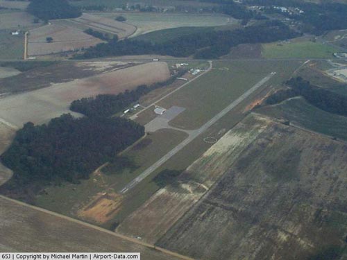
Runway Information
Runway 11/29
|
Dimension: |
3000 x 50 ft / 914.4 x 15.2 m |
|
Surface: |
ASPH, Fair Condition |
|
Weight
Limit: |
Single wheel: 20000 lbs. |
|
Edge
Lights: |
Medium |
|
|
Runway 11 |
Runway 29 |
|
Traffic
Pattern: |
Left |
Left |
|
Markings: |
Basic, Fair Condition |
Basic, Fair Condition |
|
Obstruction: |
15 ft road, 425.0 ft from runway, 15:1 slope
to clear |
15 ft road, 425.0 ft from runway, 15:1 slope
to clear |
|
Radio Navigation
Aids
|
ID |
Type |
Name |
Ch |
Freq |
Var |
Dist |
|
HQU |
NDB |
Thomson-mcduffie |
|
333.00 |
04W |
19.5 nm |
|
BXG |
NDB |
Burke County |
|
356.00 |
04W |
21.9 nm |
|
AA |
NDB |
Cedar |
|
341.00 |
04W |
22.0 nm |
|
EMR |
NDB |
Emory |
|
385.00 |
04W |
24.2 nm |
|
LNH |
NDB |
Millen |
|
205.00 |
05W |
28.8 nm |
|
HIT |
NDB |
Kaolin |
|
360.00 |
05W |
30.6 nm |
|
EEX |
NDB |
Emanuel County |
|
309.00 |
04W |
33.6 nm |
|
UMB |
NDB |
Culvr |
|
380.00 |
04W |
39.3 nm |
|
IIY |
NDB |
Washington/wilkes County |
|
435.00 |
03W |
39.6 nm |
|
VV |
NDB |
Junne |
|
353.00 |
05W |
40.9 nm |
|
AIK |
NDB |
Aiken |
|
347.00 |
04W |
43.8 nm |
|
BKO |
NDB |
Barnwell |
|
392.00 |
06W |
48.8 nm |
|
IRQ |
VORTAC |
Colliers |
086X |
113.90 |
04W |
31.2 nm |
|
DBN |
VORTAC |
Dublin |
078X |
113.10 |
01W |
45.8 nm |
Remarks
Based
Aircraft
|
Aircraft
based on field: |
6 |
|
Single
Engine Airplanes: |
6 |
Operational Statistics
Time Period: 2005-04-12 - 2006-04-11
|
Aircraft
Operations: |
39/Week |
|
General
Aviation Local: |
60.0% |
|
General
Aviation Itinerant: |
40.0% |
Wrens Memorial Airport
Address:
Jefferson County, GA
Tel:
706-547-3000
Images
and information placed above are from
http://www.airport-data.com/airport/65J/
We
thank them for the data!
| General
Info |
| Country |
United
States |
| State |
GEORGIA
|
| FAA ID |
65J
|
| Latitude |
33-13-21.522N
|
| Longitude |
082-23-01.450W
|
| Elevation |
450 feet
|
| Near City |
WRENS
|
We don't guarantee the information is fresh and accurate. The data may
be wrong or outdated.
For more up-to-date information please refer to other sources.
|
|


