 |
|
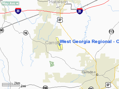
West Georgia Regional - O V Gray Field Airport |
West Georgia Regional Airport
O. V. Gray Field |
| IATA: none â ICAO: KCTJ â FAA LID: CTJ |
| Summary |
| Airport type |
Public |
| Owner/Operator |
West Georgia Airport Authority |
| Serves |
Carrollton, Georgia |
| Elevation AMSL |
1,161 ft / 354 m |
| Coordinates |
33°37â²54â³N 085°09â²08â³W / 33.63167°N 85.15222°W / 33.63167; -85.15222 |
| Runways |
| Direction |
Length |
Surface |
| ft |
m |
| 17/35 |
5,503 |
1,677 |
Asphalt |
| Statistics (2008) |
| Aircraft operations |
24,500 |
| Based aircraft |
43 |
| Source: Federal Aviation Administration |
West Georgia Regional Airport (ICAO: KCTJ, FAA LID: CTJ), also known as O. V. Gray Field, is a public use airport located five nautical miles (9 km) northwest of the central business district of Carrollton, in Carroll County, Georgia, United States. It is owned by the West Georgia Airport Authority.
Although most U.S. airports use the same three-letter location identifier for the FAA and IATA, this airport is assigned CTJ by the FAA but has no designation from the IATA.
Facilities and aircraft
The airport covers an area of 396 acres (160 ha) at an elevation of 1,161 feet (354 m) above mean sea level. It has one asphalt paved runway designated 17/35 which measures 5,503 by 100 feet (1,677 x 30 m).
For the 12-month period ending April 30, 2008, the airport had 24,500 aircraft operations, an average of 67 per day: 98% general aviation and 2% military. At that time there were 43 aircraft based at this airport: 91% single-engine, 5% multi-engine, 2% jet and 2% helicopter.
The above content comes from Wikipedia and is published under free licenses – click here to read more.
Location
& QuickFacts
|
FAA Information Effective: |
2007-07-05 |
|
Airport
Identifier: |
CTJ |
|
Airport
Status: |
Operational |
|
Longitude/Latitude: |
085-09-08.3950W/33-37-54.8150N
-85.152332/33.631893 (Estimated) |
|
Elevation: |
1161 ft / 353.87 m (Surveyed) |
|
Land: |
396 acres |
|
From
nearest city: |
5 nautical miles NW of Carrollton, GA |
|
Location: |
Carroll County, GA |
|
Magnetic Variation: |
04W (2005) |
Owner
& Manager
|
Ownership: |
Publicly owned |
|
Owner: |
West Ga Arpt Auth |
|
Address: |
64 Lynnwood Ct.
Temple, GA 30179 |
|
Phone
number: |
678-722-8924 |
|
Manager: |
John Howard |
|
Address: |
64 Lynnwood Ct.
Temple, GA 30179 |
|
Phone number: |
678-722-8924 |
Airport
Operations and Facilities
|
Airport Use: |
Open to public |
|
Wind
indicator: |
Yes |
|
Segmented
Circle: |
Yes |
|
Control
Tower: |
No |
|
Lighting
Schedule: |
DUSK-DAWN
MIRL RY 17/35 PRESET MED INTST DUSK-2200, AFT 2200 ACTVT
- CTAF.
ACTVT PAPI RYS 17 & 35 - CTAF. |
|
Beacon
Color: |
Clear-Green (lighted land airport) |
|
Landing
fee charge: |
No |
|
Sectional
chart: |
Atlanta |
|
Region: |
ASO - Southern |
|
Boundary
ARTCC: |
ZTL - Atlanta |
|
Tie-in
FSS: |
MCN - Macon |
|
FSS
on Airport: |
No |
|
FSS
Toll Free: |
1-800-WX-BRIEF |
|
NOTAMs
Facility: |
MCN (NOTAM-d service avaliable) |
|
Federal Agreements: |
NGY |
Airport
Communications
|
CTAF: |
122.700 |
|
Unicom: |
122.700 |
Airport
Services
|
Fuel available: |
100LLA1 |
|
Airframe Repair: |
MAJOR |
|
Power Plant Repair: |
MAJOR |
|
Bottled
Oxygen: |
NONE |
|
Bulk
Oxygen: |
HIGH |
|
Runway Information
Runway 17/35
|
Dimension: |
5652 x 100 ft / 1722.7 x 30.5 m |
|
Surface: |
ASPH, Good Condition |
|
Weight
Limit: |
Single wheel: 43000 lbs.
Dual wheel: 56000 lbs.
Dual
tandem wheel: 83000 lbs. |
|
Edge
Lights: |
Medium |
|
|
Runway 17 |
Runway 35 |
|
Longitude: |
085-09-17.7000W |
085-08-59.0900W |
|
Latitude: |
33-38-21.6700N |
33-37-27.9600N |
|
Elevation: |
1160.00
ft |
1110.00
ft |
|
Alignment: |
127 |
127 |
|
ILS
Type: |
|
LOC/GS |
|
Traffic
Pattern: |
Left |
Left |
|
Markings: |
Precision instrument, Good Condition |
Precision instrument, Good Condition |
|
Crossing
Height: |
33.00
ft |
35.00
ft |
|
VASI: |
4-light PAPI on left side |
4-light PAPI on left side |
|
Visual
Glide Angle: |
3.00° |
3.00° |
|
Obstruction: |
94 ft trees, 2268.0 ft from runway, 22:1 slope
to clear |
27 ft trees, 956.0 ft from runway, 425 ft left
of centerline, 28:1 slope to clear |
|
Radio Navigation
Aids
|
ID |
Type |
Name |
Ch |
Freq |
Var |
Dist |
|
GPQ |
NDB |
Carrollton |
|
278.00 |
02W |
4.1 nm |
|
FT |
NDB |
Flanc |
|
344.00 |
02W |
26.8 nm |
|
EQQ |
NDB |
Coweta County |
|
234.00 |
03W |
31.5 nm |
|
EVZ |
NDB |
Cartersville |
|
308.00 |
04W |
37.4 nm |
|
FF |
NDB |
Pecat |
|
316.00 |
02W |
38.9 nm |
|
OYD |
NDB |
Floyd |
|
388.00 |
02W |
40.1 nm |
|
BR |
NDB |
Redan |
|
266.00 |
02W |
42.1 nm |
|
OUK |
NDB |
Calhoun |
|
323.00 |
02W |
47.6 nm |
|
PIM |
NDB |
Pine Mountain |
|
272.00 |
03W |
49.5 nm |
|
DJD |
NDB |
Canton |
|
415.00 |
04W |
49.9 nm |
|
DOB |
TACAN |
Dobbins |
077X |
|
01W |
36.4 nm |
|
TDG |
VOR/DME |
Talladega |
025X |
108.80 |
02E |
44.7 nm |
|
PDK |
VOR/DME |
Peachtree |
113X |
116.60 |
02W |
45.1 nm |
|
RMG |
VORTAC |
Rome |
101X |
115.40 |
01E |
31.9 nm |
|
LGC |
VORTAC |
Lagrange |
103X |
115.60 |
01E |
35.1 nm |
|
ATL |
VORTAC |
Atlanta |
116X |
116.90 |
00W |
35.9 nm |
|
ATL |
VOT |
Atlanta Muni |
|
111.00 |
|
36.4 nm |
Remarks
- UNLGTD
RWY DISTANCE MARKERS W SIDE OF RWY.
- DEER
ON & NEAR RWYS AT ALL TIMES.
Based
Aircraft
|
Aircraft
based on field: |
100 |
|
Single
Engine Airplanes: |
92 |
|
Multi
Engine Airplanes: |
6 |
|
Jet Engine
Airplanes: |
2 |
Operational Statistics
Time Period: 2004-11-09
- 2005-11-08
|
Aircraft
Operations: |
96/Day |
|
Air Taxi: |
1.4% |
|
General
Aviation Local: |
34.3% |
|
General
Aviation Itinerant: |
62.9% |
|
Military: |
1.4% |
West Georgia Regional - O V Gray Field
Airport
Address:
Carroll County, GA
Tel:
678-722-8924
Images
and information placed above are from
http://www.airport-data.com/airport/CTJ/
We
thank them for the data!
| General
Info |
| Country |
United
States |
| State |
GEORGIA
|
| FAA ID |
CTJ
|
| Latitude |
33-37-51.700N
|
| Longitude |
085-09-07.300W
|
| Elevation |
1161 feet
|
| Near City |
CARROLLTON
|
We don't guarantee the information is fresh and accurate. The data may
be wrong or outdated.
For more up-to-date information please refer to other sources.
|
|


