 |
|
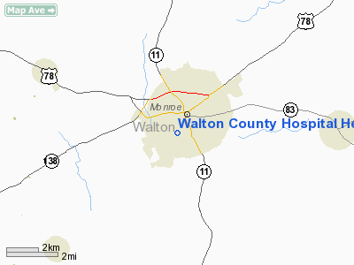
Walton County Hospital Heliport |
Location
& QuickFacts
|
FAA Information Effective: |
2007-07-05 |
|
Airport
Identifier: |
GA38 |
|
Airport
Status: |
Operational |
|
Longitude/Latitude: |
083-43-04.6260W/33-46-59.4110N
-83.717952/33.783170 (Estimated) |
|
Elevation: |
880 ft / 268.22 m (Estimated) |
|
Land: |
0
acres |
|
From
nearest city: |
0 nautical miles SW of Monroe, GA |
|
Location: |
Walton County, GA |
|
Magnetic Variation: |
02W (1985) |
Owner
& Manager
|
Ownership: |
Publicly owned |
|
Owner: |
Walton County Hospital |
|
Address: |
330 Alcove St.
Monroe, GA 30655 |
|
Phone number: |
404-267-8461 |
|
Manager: |
Walton County Hospital |
|
Address: |
330 Alcove St.
Monroe, GA 30655 |
|
Phone number: |
404-267-8461 |
Airport
Operations and Facilities
|
Airport Use: |
Private
MEDICAL USE |
|
Segmented
Circle: |
No |
|
Control
Tower: |
No |
|
Sectional
chart: |
Atlanta |
|
Region: |
ASO - Southern |
|
Boundary
ARTCC: |
ZTL - Atlanta |
|
Tie-in
FSS: |
MCN - Macon |
|
FSS
Toll Free: |
1-800-WX-BRIEF |
|
Runway Information
Helipad H1
|
Dimension: |
30
x 30 ft / 9.1 x 9.1 m |
|
Surface: |
CONC, |
|
|
Runway H1 |
Runway |
|
Traffic
Pattern: |
Left |
Left |
|
Radio Navigation
Aids
|
ID |
Type |
Name |
Ch |
Freq |
Var |
Dist |
|
JNM |
NDB |
Monroe |
|
392.00 |
03W |
2.8 nm |
|
VOF |
NDB |
Alcovy |
|
370.00 |
03W |
9.8 nm |
|
BMW |
NDB |
Barrow County |
|
404.00 |
03W |
11.2 nm |
|
DDA |
NDB |
Commerce |
|
244.00 |
03W |
19.4 nm |
|
BJT |
NDB |
Bulldog |
|
221.00 |
03W |
26.9 nm |
|
FKV |
NDB |
Flowery Branch |
|
365.00 |
03W |
26.9 nm |
|
BR |
NDB |
Redan |
|
266.00 |
02W |
30.8 nm |
|
VV |
NDB |
Junne |
|
353.00 |
05W |
35.8 nm |
|
AJR |
NDB |
Habersham |
|
347.00 |
03W |
44.0 nm |
|
JHH |
NDB |
Griffin |
|
412.00 |
04W |
44.1 nm |
|
IIY |
NDB |
Washington/wilkes County |
|
435.00 |
03W |
45.2 nm |
|
FT |
NDB |
Flanc |
|
344.00 |
02W |
46.0 nm |
|
UMB |
NDB |
Culvr |
|
380.00 |
04W |
47.2 nm |
|
DJD |
NDB |
Canton |
|
415.00 |
04W |
47.6 nm |
|
FF |
NDB |
Pecat |
|
316.00 |
02W |
48.2 nm |
|
DOB |
TACAN |
Dobbins |
077X |
|
01W |
40.2 nm |
|
PDK |
VOR/DME |
Peachtree |
113X |
116.60 |
02W |
29.5 nm |
|
AHN |
VORTAC |
Athens |
33 |
109.60 |
00E |
22.0 nm |
|
ATL |
VORTAC |
Atlanta |
116X |
116.90 |
00W |
37.0 nm |
|
ATL |
VOT |
Atlanta Muni |
|
111.00 |
|
36.2 nm |
Remarks
- VFR;
PRIVATE USE; APCH/DEP ROUTES ARE FROM 005 DEGRESS TO 025 DEGREES &
FROM 210 DEGREES TO 250 DEGREES; AREA IS MARKED; WIND INDECATOR IS MAINTAINED
Walton County Hospital Heliport
Address:
Walton County, GA
Tel:
404-267-8461
Images
and information placed above are from
http://www.airport-data.com/airport/GA38/
We
thank them for the data!
| General
Info |
| Country |
United
States |
| State |
GEORGIA
|
| FAA ID |
GA38
|
| Latitude |
33-46-59.411N
|
| Longitude |
083-43-04.626W
|
| Elevation |
880 feet
|
| Near City |
MONROE
|
We don't guarantee the information is fresh and accurate. The data may
be wrong or outdated.
For more up-to-date information please refer to other sources.
|
|


