 |
|
| W. H. 'Bud' Barron Airport |
 |
| IATA: DBN â ICAO: KDBN â FAA LID: DBN |
| Summary |
| Airport type |
Public |
| Owner |
Laurens County |
| Serves |
Dublin, Georgia |
| Elevation AMSL |
309 ft / 94 m |
| Coordinates |
32°33â²52â³N 082°59â²07â³W / 32.56444°N 82.98528°W / 32.56444; -82.98528 |
| Runways |
| Direction |
Length |
Surface |
| ft |
m |
| 2/20 |
6,002 |
1,829 |
Asphalt |
| 14/32 |
5,004 |
1,525 |
Asphalt |
| Statistics (2009) |
| Aircraft operations |
24,950 |
| Based aircraft |
32 |
| Source: Federal Aviation Administration |
W. H. 'Bud' Barron Airport (IATA: DBN, ICAO: KDBN, FAA LID: DBN) is a county-owned public-use airport in Laurens County, Georgia, United States. It is located three nautical miles (6 km) northwest of the central business district of Dublin, Georgia.
Facilities and aircraft
W. H. 'Bud' Barron Airport covers an area of 905 acres (366 ha) at an elevation of 309 feet (94 m) above mean sea level. It has two asphalt paved runways: 2/20 is 6,002 by 150 feet (1,829 x 46 m) and 14/32 is 5,004 by 100 feet (1,525 x 30 m).
For the 12-month period ending March 17, 2009, the airport had 24,950 aircraft operations, an average of 68 per day: 99% general aviation and 1% military. At that time there were 32 aircraft based at this airport: 75% single-engine, 22% multi-engine and 3% jet.
The above content comes from Wikipedia and is published under free licenses – click here to read more.
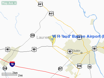
Location
& QuickFacts
|
FAA Information Effective: |
2007-07-05 |
|
Airport
Identifier: |
DBN |
|
Airport
Status: |
Operational |
|
Longitude/Latitude: |
082-59-07.0000W/32-33-51.9000N
-82.985278/32.564417 (Estimated) |
|
Elevation: |
309 ft / 94.18 m (Estimated) |
|
Land: |
905 acres |
|
From
nearest city: |
3 nautical miles NW of Dublin, GA |
|
Location: |
Laurens County, GA |
|
Magnetic Variation: |
04W (2000) |
Owner
& Manager
|
Ownership: |
Publicly owned |
|
Owner: |
Laurens County |
|
Address: |
P O Box 2011
Dublin, GA 31040 |
|
Phone number: |
478-272-4755 |
|
Manager: |
Brian Rogers, County Adm |
|
Address: |
Po Box 2011
Dublin, GA 31040 |
|
Phone number: |
478-272-4755 |
Airport
Operations and Facilities
|
Airport Use: |
Open to public |
|
Wind
indicator: |
Yes |
|
Segmented
Circle: |
Yes |
|
Control
Tower: |
No |
|
Lighting
Schedule: |
DUSK-DAWN
ACTVT MALSR RY 02 - CTAF. HIRL RY 02/20 OPER CONT DUSK-2200;
AFTER 2200 ACTVT - CTAF. |
|
Beacon
Color: |
Clear-Green (lighted land airport) |
|
Landing
fee charge: |
No |
|
Sectional
chart: |
Atlanta |
|
Region: |
ASO - Southern |
|
Boundary
ARTCC: |
ZTL - Atlanta |
|
Tie-in
FSS: |
MCN - Macon |
|
FSS
on Airport: |
No |
|
FSS
Toll Free: |
1-800-WX-BRIEF |
|
NOTAMs
Facility: |
MCN (NOTAM-d service avaliable) |
|
Federal Agreements: |
NGY3 |
Airport
Communications
|
CTAF: |
122.700 |
|
Unicom: |
122.700 |
Airport
Services
|
Fuel available: |
100LLA1+
SELF-SERVICE FUEL AVBL 24 HRS WITH CREDIT CARD. |
|
Airframe Repair: |
MAJOR |
|
Power Plant Repair: |
MAJOR |
|
Bottled
Oxygen: |
NONE |
|
Bulk
Oxygen: |
NONE |
|
Runway Information
Runway 02/20
|
Dimension: |
6002 x 150 ft / 1829.4 x 45.7 m |
|
Surface: |
ASPH, Good Condition |
|
Weight
Limit: |
Single wheel: 30000 lbs.
Dual wheel: 53000 lbs. |
|
Edge
Lights: |
High |
|
|
Runway 02 |
Runway 20 |
|
Longitude: |
082-59-05.7002W |
082-58-46.0112W |
|
Latitude: |
32-33-26.2545N |
32-34-23.2508N |
|
Elevation: |
291.00
ft |
309.00
ft |
|
Alignment: |
16 |
127 |
|
ILS
Type: |
ILS/DME |
|
|
Traffic
Pattern: |
Left |
Left |
|
Markings: |
Precision instrument, Good Condition |
Precision instrument, Good Condition |
|
Crossing
Height: |
48.00
ft |
0.00 ft |
|
VASI: |
2-light PAPI on left side |
2-light PAPI on left side |
|
Visual
Glide Angle: |
3.00° |
0.00° |
|
Approach
lights: |
MALSR |
|
|
Obstruction: |
46 ft trees, 890.0 ft from runway, 550 ft left
of centerline, 15:1 slope to clear |
32 ft trees, 1256.0 ft from runway, 550 ft
left of centerline, 33:1 slope to clear |
|
Runway 14/32
|
Dimension: |
5004 x 100 ft / 1525.2 x 30.5 m |
|
Surface: |
ASPH, Fair Condition |
|
Weight
Limit: |
Single wheel: 28000 lbs.
Dual wheel: 44000 lbs. |
|
|
Runway 14 |
Runway 32 |
|
Longitude: |
082-59-40.4609W |
082-59-00.0999W |
|
Latitude: |
32-34-06.2917N |
32-33-30.4754N |
|
Elevation: |
304.00
ft |
292.00
ft |
|
Alignment: |
127 |
127 |
|
Traffic
Pattern: |
Left |
Left |
|
Markings: |
Basic, Fair Condition |
Basic, Fair Condition |
|
Obstruction: |
56 ft trees, 536.0 ft from runway, 250 ft right
of centerline, 6:1 slope to clear |
59 ft trees, 1852.0 ft from runway, 350 ft
left of centerline, 28:1 slope to clear |
|
Radio Navigation
Aids
|
ID |
Type |
Name |
Ch |
Freq |
Var |
Dist |
|
DB |
NDB |
Creke |
|
251.00 |
04W |
5.0 nm |
|
EZM |
NDB |
Eastman |
|
366.00 |
04W |
27.2 nm |
|
HIT |
NDB |
Kaolin |
|
360.00 |
05W |
27.3 nm |
|
EEX |
NDB |
Emanuel County |
|
309.00 |
04W |
27.7 nm |
|
MQW |
NDB |
Mc Rae |
|
280.00 |
03W |
28.7 nm |
|
UMB |
NDB |
Culvr |
|
380.00 |
04W |
36.4 nm |
|
BEP |
NDB |
Bay Creek |
|
350.00 |
03W |
40.1 nm |
|
UQN |
NDB |
Onyun |
|
372.00 |
04W |
40.5 nm |
|
AZE |
NDB |
Hazlehurst |
|
414.00 |
03W |
44.6 nm |
|
MHP |
NDB |
Metter |
|
432.00 |
03W |
47.1 nm |
|
DBN |
VORTAC |
Dublin |
078X |
113.10 |
01W |
7.7 nm |
|
VNA |
VORTAC |
Vienna |
112X |
116.50 |
01E |
33.5 nm |
|
MCN |
VORTAC |
Macon |
089X |
114.20 |
01E |
34.4 nm |
Remarks
Based
Aircraft
|
Aircraft
based on field: |
32 |
|
Single
Engine Airplanes: |
25 |
|
Multi
Engine Airplanes: |
6 |
|
Jet Engine
Airplanes: |
1 |
Operational Statistics
Time Period: 2006-02-21
- 2007-02-20
|
Aircraft
Operations: |
69/Day |
|
General
Aviation Local: |
75.2% |
|
General
Aviation Itinerant: |
24.0% |
|
Military: |
0.8% |
W H 'bud' Barron Airport
Address:
Laurens County, GA
Tel:
478-272-4755
Images
and information placed above are from
http://www.airport-data.com/airport/DBN/
We
thank them for the data!
| General
Info |
| Country |
United
States |
| State |
GEORGIA
|
| FAA ID |
DBN
|
| Latitude |
32-33-52.049N
|
| Longitude |
082-59-06.920W
|
| Elevation |
310 feet
|
| Near City |
DUBLIN
|
We don't guarantee the information is fresh and accurate. The data may
be wrong or outdated.
For more up-to-date information please refer to other sources.
|
|


