 |
|
| Vidalia Regional Airport |
 |
| IATA: VDI â ICAO: KVDI â FAA LID: VDI |
| Summary |
| Airport type |
Public |
| Owner |
City of Vidalia |
| Serves |
Vidalia, Georgia |
| Location |
Vidalia, Georgia |
| Elevation AMSL |
275 ft / 84 m |
| Coordinates |
32°11â²34â³N 082°22â²16â³W / 32.19278°N 82.37111°W / 32.19278; -82.37111 |
| Runways |
| Direction |
Length |
Surface |
| ft |
m |
| 6/24 |
6,003 |
1,830 |
Concrete |
| 13/31 |
5,000 |
1,524 |
Concrete |
| Statistics (2007) |
| Aircraft operations |
17,000 |
| Based aircraft |
21 |
| Source: Federal Aviation Administration |
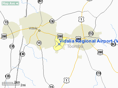
Vidalia Regional Airport (IATA: VDI, ICAO: KVDI, FAA LID: VDI) is a city-owned public-use airport located three nautical miles (6 km) southeast of the central business district of the city Vidalia, in Toombs County, Georgia, United States. Facilities and aircraft
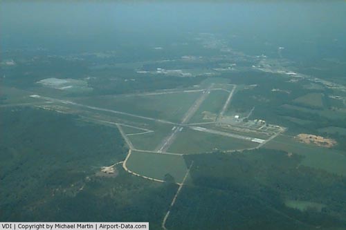
Vidalia Regional Airport covers an area of 1,245 acres (504 ha) at an elevation of 275 feet (84 m) above mean sea level. It has two concrete paved runways: 6/24 measuring 6,003 by 100 feet (1,830 x 30 m) and 13/31 measuring 5,000 by 150 feet (1,524 x 46 m).
For the 12-month period ending April 2, 2007, the airport had 17,000 aircraft operations, an average of 46 per day: 94% general aviation and 6% military. At that time there were 21 aircraft based at this airport: 86% single-engine, 10% multi-engine and 5% helicopter.
History
The airfield was opened to the public on 12 August 1940. In May 1943, during World War II, the airport was requisitioned by the United States Army Air Force, and was known as Vidalia-Lyons Army Airfield. Also known as Turner AAF Auxiliary Airfield No. 8, the airfield supported the elementary & advanced training in two-engine aircraft being conducted at Turner AAF.
The airfield inactivated on 28 December 1944, and was declared surplus in 1946.
The above content comes from Wikipedia and is published under free licenses – click here to read more.
|
 |
(Click on the photo to enlarge) |
Location
& QuickFacts
|
FAA Information Effective: |
2007-07-05 |
|
Airport
Identifier: |
VDI |
|
Airport
Status: |
Operational |
|
Longitude/Latitude: |
082-22-16.1840W/32-11-33.8160N
-82.371162/32.192727 (Estimated) |
|
Elevation: |
275 ft / 83.82 m (Surveyed) |
|
Land: |
1245 acres |
|
From
nearest city: |
3 nautical miles SE of Vidalia, GA |
|
Location: |
Toombs County, GA |
|
Magnetic Variation: |
04W (1990) |
Owner
& Manager
|
Ownership: |
Publicly owned |
|
Owner: |
City Of Vidalia |
|
Address: |
City Hall Po Box 280
Vidalia, GA 30474 |
|
Phone
number: |
912-537-7661 |
|
Manager: |
William D. Torrance, Cty Mgr |
|
Address: |
City Hall Po Box 280
Vidalia, GA 30474 |
|
Phone number: |
912-537-7661
AIRPORT PHONE 912-537-3979. |
Airport
Operations and Facilities
|
Airport Use: |
Open to public |
|
Wind
indicator: |
Yes |
|
Segmented
Circle: |
Yes |
|
Control
Tower: |
No |
|
Lighting
Schedule: |
DUSK-DAWN
HIRL RY 06/24 PRESET MED INTS DUSK-2300. AFTER 2300+ CTAF.
ACTVT MALSR RWY 24, PAPI RYS 06 & 24 - CTAF. |
|
Beacon
Color: |
Clear-Green (lighted land airport) |
|
Landing
fee charge: |
No |
|
Sectional
chart: |
Atlanta |
|
Region: |
ASO - Southern |
|
Boundary
ARTCC: |
ZJX - Jacksonville |
|
Responsible
ARTCC: |
ZJX - Jacksonville |
|
Tie-in
FSS: |
MCN - Macon |
|
FSS
on Airport: |
No |
|
FSS
Toll Free: |
1-800-WX-BRIEF |
|
NOTAMs
Facility: |
VDI (NOTAM-d service avaliable) |
|
Federal Agreements: |
NGP |
Airport
Communications
|
CTAF: |
122.800 |
|
Unicom: |
122.800 |
Airport
Services
|
Fuel available: |
100LLA1+
SELF-SERVE 100LL AVBL 24 HRS WITH CREDIT CARD. PPR FOR JET
A1+ AFTER HRS CALL 912-537-3979 OR 912-538-0871. |
|
Airframe Repair: |
MAJOR |
|
Power Plant Repair: |
MAJOR |
|
Bottled
Oxygen: |
NONE |
|
Bulk
Oxygen: |
NONE |
|
Runway Information
Runway 06/24
|
Dimension: |
6003 x 100 ft / 1829.7 x 30.5 m |
|
Surface: |
CONC, Good Condition |
|
Weight
Limit: |
Single wheel: 30000 lbs.
Dual wheel: 48000 lbs.
Dual
tandem wheel: 85000 lbs. |
|
Edge
Lights: |
High |
|
|
Runway 06 |
Runway 24 |
|
Longitude: |
082-22-45.3220W |
082-21-43.2020W |
|
Latitude: |
32-11-15.4160N |
32-11-42.5740N |
|
Elevation: |
272.00
ft |
269.00
ft |
|
Alignment: |
63 |
127 |
|
ILS
Type: |
|
ILS |
|
Traffic
Pattern: |
Left |
Left |
|
Markings: |
Precision instrument, Good Condition |
Precision instrument, Good Condition |
|
Crossing
Height: |
40.00
ft |
40.00
ft |
|
VASI: |
4-light PAPI on left side |
4-light PAPI on left side |
|
Visual
Glide Angle: |
3.00° |
3.00° |
|
Approach
lights: |
|
MALSR |
|
Runway
End Identifier: |
Yes |
Yes |
|
Obstruction: |
40 ft trees, 200.0 ft from runway, 250 ft left
of centerline |
, 50:1 slope to clear |
|
Decleard
distances: |
Take off run available 5000.00 ft
Take off distance available 5000.00 ft
Actual stop distance available 5000.00 ft
Landing distance available 5000.00 ft |
|
|
Runway 13/31
|
Dimension: |
5000 x 150 ft / 1524.0 x 45.7 m |
|
Surface: |
CONC, Fair Condition |
|
Weight
Limit: |
Single wheel: 30000 lbs.
Dual wheel: 48000 lbs.
Dual
tandem wheel: 85000 lbs. |
|
|
Runway 13 |
Runway 31 |
|
Longitude: |
082-22-40.2500W |
082-21-56.7300W |
|
Latitude: |
32-11-56.0400N |
32-11-23.1600N |
|
Elevation: |
272.00
ft |
272.00
ft |
|
Alignment: |
127 |
127 |
|
Traffic
Pattern: |
Left |
Left |
|
Markings: |
Basic, Poor Condition
RY 13 MARKINGS BADLY FADED. |
Basic, Poor Condition
RY 31 MARKINGS BADLY FADED. |
|
Obstruction: |
28 ft trees, 816.0 ft from runway, 300 ft left
of centerline, 22:1 slope to clear |
39 ft trees, 980.0 ft from runway, 300 ft right
of centerline, 20:1 slope to clear |
|
Radio Navigation
Aids
|
ID |
Type |
Name |
Ch |
Freq |
Var |
Dist |
|
UQN |
NDB |
Onyun |
|
372.00 |
04W |
4.1 nm |
|
RVJ |
NDB |
Prison |
|
424.00 |
03W |
13.8 nm |
|
MHP |
NDB |
Metter |
|
432.00 |
03W |
18.2 nm |
|
AZE |
NDB |
Hazlehurst |
|
414.00 |
03W |
23.5 nm |
|
CWV |
NDB |
Claxton |
|
395.50 |
04W |
25.0 nm |
|
MQW |
NDB |
Mc Rae |
|
280.00 |
03W |
26.7 nm |
|
EEX |
NDB |
Emanuel County |
|
309.00 |
04W |
28.8 nm |
|
BHC |
NDB |
Baxley |
|
376.00 |
04W |
28.9 nm |
|
DB |
NDB |
Creke |
|
251.00 |
04W |
36.9 nm |
|
BZ |
NDB |
Bullo |
|
407.00 |
05W |
38.3 nm |
|
EZM |
NDB |
Eastman |
|
366.00 |
04W |
40.0 nm |
|
JES |
NDB |
Slover |
|
340.00 |
04W |
45.7 nm |
|
LNH |
NDB |
Millen |
|
205.00 |
05W |
46.9 nm |
|
JYL |
NDB |
Sylvania |
|
245.00 |
04W |
48.0 nm |
|
MOQ |
NDB |
Mc Intosh |
|
263.00 |
04W |
49.0 nm |
|
DBN |
VORTAC |
Dublin |
078X |
113.10 |
01W |
32.2 nm |
|
AMG |
VORTAC |
Alma |
098X |
115.10 |
00E |
40.1 nm |
Remarks
- GCO
AVBL ON FREQ 121.725 THRU FLT SVCS.
Based
Aircraft
|
Aircraft
based on field: |
21 |
|
Single
Engine Airplanes: |
18 |
|
Multi
Engine Airplanes: |
2 |
|
Helicopters: |
1 |
Operational Statistics
Time Period: 2006-04-03
- 2007-04-02
|
Aircraft
Operations: |
47/Day |
|
General
Aviation Local: |
64.7% |
|
General
Aviation Itinerant: |
29.4% |
|
Military: |
5.9% |
Vidalia Regional Airport
Address:
Toombs County, GA
Tel:
912-537-7661
Images
and information placed above are from
http://www.airport-data.com/airport/VDI/
We
thank them for the data!
| General
Info |
| Country |
United
States |
| State |
GEORGIA
|
| FAA ID |
VDI
|
| Latitude |
32-11-33.200N
|
| Longitude |
082-22-19.000W
|
| Elevation |
274 feet
|
| Near City |
VIDALIA
|
We don't guarantee the information is fresh and accurate. The data may
be wrong or outdated.
For more up-to-date information please refer to other sources.
|
|


