 |
|
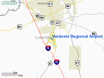
Valdosta Regional Airport |
| Valdosta Regional Airport |
| IATA: VLD â ICAO: KVLD â FAA LID: VLD |
| Summary |
| Airport type |
Public |
| Owner |
Valdosta-Lowndes County Airport Authority |
| Serves |
Valdosta, Georgia |
| Elevation AMSL |
203 ft / 62 m |
| Coordinates |
30°46â²53â³N 083°16â²34â³W / 30.78139°N 83.27611°W / 30.78139; -83.27611 |
| Website |
www.FlyValdosta.com |
| Runways |
| Direction |
Length |
Surface |
| ft |
m |
| 17/35 |
8,002 |
2,439 |
Asphalt |
| 4/22 |
5,598 |
1,706 |
Asphalt |
| 13/31 |
3,636 |
1,108 |
Asphalt |
| Statistics (2007) |
| Aircraft operations |
73,565 |
| Based aircraft |
53 |
| Source: Federal Aviation Administration |
Valdosta Regional Airport (IATA: VLD, ICAO: KVLD, FAA LID: VLD) is a public-use airport located three nautical miles (6 km) south of the central business district of Valdosta, a city in Lowndes County, Georgia, United States. It is owned by the Valdosta-Lowndes County Airport Authority. The airport is mostly used for general aviation, but is also served by one commercial airline. Facilities and aircraft
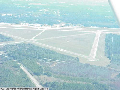
Valdosta Regional Airport covers an area of 760 acres (308 ha) at an elevation of 203 feet (62 m) above mean sea level. It has three asphalt paved runways: 17/35 measuring 8,002 x 150 ft. (2,439 x 46 m), 4/22 measuring 5,598 x 100 ft. (1,706 x 30 m), and 13/31 measuring 3,636 x 75 ft. (1,108 x 23 m).
After the completion of runway 17/35 in the summer of 2007, Valdosta now has the third longest runway in the state of Georgia (excluding military bases). The longest runway is at Hartsfield-Jackson Atlanta International Airport and the second longest is at the Savannah/Hilton Head International Airport.
For the 12-month period ending May 31, 2007, the airport had 73,565 aircraft operations, an average of 201 per day: 55% general aviation, 41% military, 3% air taxi and 1% scheduled commercial. At that time there were 53 aircraft based at this airport: 68% single-engine, 28% multi-engine and 4% jet.
Airlines and destinations
| Airlines |
Destinations |
| Delta Connection operated by Atlantic Southeast Airlines |
Atlanta |
The above content comes from Wikipedia and is published under free licenses – click here to read more.
|
 |
(Click on the photo to enlarge) |
Location
& QuickFacts
|
FAA Information Effective: |
2007-07-05 |
|
Airport
Identifier: |
VLD |
|
Airport
Status: |
Operational |
|
Longitude/Latitude: |
083-16-36.2000W/30-46-57.0000N
-83.276722/30.782500 (Estimated) |
|
Elevation: |
203 ft / 61.87 m (Surveyed) |
|
Land: |
760 acres |
|
From
nearest city: |
3 nautical miles S of Valdosta, GA |
|
Location: |
Lowndes County, GA |
|
Magnetic Variation: |
02W (1985) |
Owner
& Manager
|
Ownership: |
Publicly owned |
|
Owner: |
Valdosta-lowndes Cty Apt Auth |
|
Address: |
1750 Arpt Rd
Valdosta, GA 31601 |
|
Phone number: |
229-333-1833 |
|
Manager: |
Mr. Robert H. Holliway |
|
Address: |
1750 Arpt Rd
Valdosta, GA 31601 |
|
Phone number: |
229-333-1833 |
Airport
Operations and Facilities
|
Airport Use: |
Open to public |
|
Wind
indicator: |
Yes |
|
Segmented
Circle: |
Yes |
|
Control
Tower: |
Yes |
|
Lighting
Schedule: |
DUSK-DAWN
WHEN ATCT CLSD ACTVT HIRL RY 17/35, PAPI RYS 17 & 35,
REIL RY 17 & MALSR RY 35 - CTAF. MIRL RYS 04/22 &
13/31, PAPI RYS 04 & 22, AND REIL RYS 04 & 22 UNAVBL
WHEN ATCT CLSD. |
|
Beacon
Color: |
Clear-Green (lighted land airport) |
|
Landing
fee charge: |
No |
|
Sectional
chart: |
Jacksonville |
|
Region: |
ASO - Southern |
|
Boundary
ARTCC: |
ZJX - Jacksonville |
|
Tie-in
FSS: |
MCN - Macon |
|
FSS
on Airport: |
No |
|
FSS
Toll Free: |
1-800-WX-BRIEF |
|
NOTAMs
Facility: |
VLD (NOTAM-d service avaliable) |
|
Certification
type/date: |
I A S 05/1973
CLSD TO UNSKED ACR OPNS WITH MORE THAN 30 PSGR SEATS EXCP
24 HR PPR CALL AMGR 229-333-1833. |
|
Federal Agreements: |
NGRY3 |
Airport
Communications
|
CTAF: |
120.900 |
|
Unicom: |
122.950 |
Airport
Services
|
Fuel available: |
100LLA1+ |
|
Airframe Repair: |
MAJOR |
|
Power Plant Repair: |
MAJOR |
|
Bottled
Oxygen: |
NONE |
|
Bulk
Oxygen: |
NONE |
|
Runway Information
Runway 04/22
|
Dimension: |
5598 x 100 ft / 1706.3 x 30.5 m |
|
Surface: |
ASPH, Good Condition |
|
Surface
Treatment: |
Saw-cut or plastic Grooved |
|
Weight
Limit: |
Single wheel: 24000 lbs.
Dual wheel: 95000 lbs. |
|
Edge
Lights: |
Medium |
|
|
Runway 04 |
Runway 22 |
|
Longitude: |
083-17-06.6220W |
083-16-29.0660W |
|
Latitude: |
30-46-40.3870N |
30-47-25.3120N |
|
Elevation: |
199.00
ft |
196.00
ft |
|
Alignment: |
36 |
127 |
|
Traffic
Pattern: |
Left |
Left |
|
Markings: |
Basic, Good Condition |
Basic, Good Condition |
|
Crossing
Height: |
46.00
ft |
51.00
ft |
|
VASI: |
4-light PAPI on left side |
4-light PAPI on left side |
|
Visual
Glide Angle: |
3.25° |
3.25° |
|
Runway
End Identifier: |
Yes |
Yes |
|
Centerline
Lights: |
No |
No |
|
Touchdown
Lights: |
No |
No |
|
Obstruction: |
7 ft trees, 300.0 ft from runway, 70 ft right
of centerline, 14:1 slope to clear |
48 ft trees, 1175.0 ft from runway, 320 ft
left of centerline, 20:1 slope to clear |
|
Runway 13/31
|
Dimension: |
3636 x 75 ft / 1108.3 x 22.9 m |
|
Surface: |
ASPH, Fair Condition |
|
Weight
Limit: |
Single wheel: 24000 lbs.
Dual wheel: 155000 lbs. |
|
Edge
Lights: |
Medium |
|
|
Runway 13 |
Runway 31 |
|
Longitude: |
083-16-54.6370W |
083-16-20.8410W |
|
Latitude: |
30-47-02.2200N |
30-46-41.1500N |
|
Elevation: |
201.00
ft |
196.00
ft |
|
Alignment: |
126 |
127 |
|
Traffic
Pattern: |
Left |
Left |
|
Markings: |
Basic, Good Condition |
Basic, Good Condition |
|
Runway
End Identifier: |
No |
No |
|
Centerline
Lights: |
No |
No |
|
Touchdown
Lights: |
No |
No |
|
Obstruction: |
56 ft trees, 1325.0 ft from runway, 175 ft
right of centerline, 20:1 slope to clear |
40 ft trees, 1320.0 ft from runway, 175 ft
right of centerline, 20:1 slope to clear |
|
Runway 17/35
|
Dimension: |
6302 x 150 ft / 1920.8 x 45.7 m |
|
Surface: |
ASPH, Good Condition |
|
Surface
Treatment: |
Saw-cut or plastic Grooved |
|
Weight
Limit: |
Single wheel: 60000 lbs.
Dual wheel: 98000 lbs.
Dual
tandem wheel: 180000 lbs. |
|
Edge
Lights: |
High |
|
|
Runway 17 |
Runway 35 |
|
Longitude: |
083-16-30.7780W |
083-16-19.2560W |
|
Latitude: |
30-47-25.6650N |
30-46-24.0910N |
|
Elevation: |
196.00
ft |
198.00
ft |
|
Alignment: |
127 |
127 |
|
ILS
Type: |
|
ILS |
|
Traffic
Pattern: |
Left |
Left |
|
Markings: |
Precision instrument, Good Condition |
Precision instrument, Good Condition |
|
Crossing
Height: |
51.00
ft |
51.00
ft |
|
VASI: |
4-light PAPI on left side |
4-light PAPI on left side |
|
Visual
Glide Angle: |
3.00° |
3.00° |
|
Approach
lights: |
|
MALSR |
|
Runway
End Identifier: |
Yes |
No |
|
Centerline
Lights: |
No |
No |
|
Touchdown
Lights: |
No |
No |
|
Obstruction: |
55 ft trees, 1875.0 ft from runway, 60 ft right
of centerline, 25:1 slope to clear |
56 ft trees, 3000.0 ft from runway, 875 ft
left of centerline, 50:1 slope to clear |
|
Radio Navigation
Aids
|
ID |
Type |
Name |
Ch |
Freq |
Var |
Dist |
|
GTP |
NDB |
Patten |
|
245.00 |
02W |
30.3 nm |
|
HOE |
NDB |
Homerville |
|
209.00 |
03W |
30.8 nm |
|
TM |
NDB |
Tifto |
|
409.00 |
03W |
36.0 nm |
|
OWC |
NDB |
Coffee County |
|
390.00 |
03W |
41.6 nm |
|
CYR |
NDB |
Caidy |
|
338.00 |
01W |
46.0 nm |
|
FPY |
NDB |
Foley |
|
254.00 |
03W |
49.9 nm |
|
SUR |
NDB |
Fitzgerald |
|
362.00 |
03W |
49.9 nm |
|
IFM |
VOR |
Tift Myers |
|
112.50 |
01W |
40.3 nm |
|
OTK |
VOR/DME |
Valdosta |
095X |
114.80 |
02W |
0.2 nm |
|
MGR |
VOR/DME |
Moultrie |
025X |
108.80 |
02W |
32.6 nm |
|
VAD |
VORTAC |
Moody |
080X |
113.30 |
03W |
11.5 nm |
|
GEF |
VORTAC |
Greenville |
027X |
109.00 |
01E |
29.6 nm |
|
TAY |
VORTAC |
Taylor |
076X |
112.90 |
03W |
41.0 nm |
|
AYS |
VORTAC |
Waycross |
039X |
110.20 |
00E |
47.3 nm |
Remarks
- RY
04/22 HAS 25 FT PAVED SHOULDERS WITH VEGETATION; RY 13/31 HAS 37.5 FT
PAVED SHOULDERS.
- RY
13/31 CLSD TO ACR OPNS WITH MORE THAN 30 PSGR SEATS.
- CONTRACT
JET A FUEL AVAILABLE FROM FBO FOR MIL ACFT.
- RY
13/31 NW 860 FT NOT VISIBLE FROM THE TWR DUE TO TREES.
Based
Aircraft
|
Aircraft
based on field: |
53 |
|
Single
Engine Airplanes: |
36 |
|
Multi
Engine Airplanes: |
15 |
|
Jet Engine
Airplanes: |
2 |
Major Carriers
Serving This Airport
| Atlantic Southeast Airlines |
100.0% |
Most Popular Destinations
|
Hartsfield
- Jackson Atlanta Intl (ATL) |
100.0% |
Most Popular Aircraft
|
N633AS |
3.8% |
|
N632AS |
3.4% |
|
N642AS |
3.1% |
|
N636AS |
3.1% |
|
N643AS |
3.1% |
|
N637AS |
3.1% |
|
N641AS |
2.7% |
|
N634AS |
2.7% |
|
N640AS |
2.3% |
|
N848AS |
1.9% |
Operational Statistics
Time Period: 2005-06-01
- 2006-05-31
|
Aircraft
Operations: |
200/Day |
|
Commerical: |
0.9% |
|
Air Taxi: |
3.0% |
|
General
Aviation Local: |
22.1% |
|
General
Aviation Itinerant: |
28.4% |
|
Military: |
45.5% |
Valdosta Regional Airport
Address:
Lowndes County, GA
Tel:
229-333-1833
Images
and information placed above are from
http://www.airport-data.com/airport/VLD/
We
thank them for the data!
| General
Info |
| Country |
United
States |
| State |
GEORGIA
|
| FAA ID |
VLD
|
| Latitude |
30-46-57.000N
|
| Longitude |
083-16-36.200W
|
| Elevation |
203 feet
|
| Near City |
VALDOSTA
|
We don't guarantee the information is fresh and accurate. The data may
be wrong or outdated.
For more up-to-date information please refer to other sources.
|
|


