 |
|
Toccoa Regional Letourneau Field Airport |
Toccoa Airport
R.G. LeTourneau Field |
 |
| IATA: TOC â ICAO: KTOC â FAA LID: TOC |
| Summary |
| Airport type |
Public |
| Owner |
Toccoa-Stephens County Authority |
| Serves |
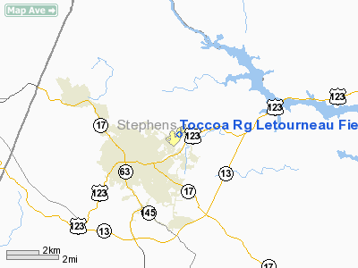
Toccoa, Georgia |
| Elevation AMSL |
996 ft / 304 m |
| Coordinates |
34°35â²34â³N 083°17â²47â³W / 34.59278°N 83.29639°W / 34.59278; -83.29639 |
| Runways |
| Direction |
Length |
Surface |
| ft |
m |
| 2/20 |
5,008 |
1,526 |
Asphalt |
| 9/27 |
2,951 |
899 |
Asphalt |
| Statistics (2009) |
| Aircraft operations |
26,000 |
| Based aircraft |
32 |
| Source: Federal Aviation Administration |
Toccoa Airport (IATA: TOC, ICAO: KTOC, FAA LID: TOC), also known as R.G. LeTourneau Field, is a public use airport located two nautical miles (3.7 km) northeast of the central business district of Toccoa, a city in Stephens County, Georgia, United States. It is owned by the Toccoa-Stephens County Authority. According to the FAA's National Plan of Integrated Airport Systems for 2009â2013, it is categorized as a general aviation airport.
Facilities and aircraft
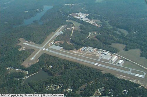
The airport covers an area of 285 acres (115 ha) at an elevation of 996 feet (304 m) above mean sea level. It has two asphalt paved runways: 2/20 is 5,008 by 100 feet (1,526 x 30 m) and 9/27 is 2,951 by 50 feet (899 x 15 m).
For the 12-month period ending May 26, 2009, the airport had 26,000 general aviation aircraft operations, an average of 71 per day. At that time there were 32 aircraft based at this airport: 72% single-engine and 28% multi-engine.
The above content comes from Wikipedia and is published under free licenses – click here to read more.
|
 |
(Click on the photo to enlarge) |
Location
& QuickFacts
|
FAA Information Effective: |
2007-07-05 |
|
Airport
Identifier: |
TOC |
|
Airport
Status: |
Operational |
|
Longitude/Latitude: |
083-17-46.9380W/34-35-34.1220N
-83.296372/34.592812 (Estimated) |
|
Elevation: |
996 ft / 303.58 m (Surveyed) |
|
Land: |
285 acres |
|
From
nearest city: |
2 nautical miles NE of Toccoa, GA |
|
Location: |
Stephens County, GA |
|
Magnetic Variation: |
05W (2000) |
Owner
& Manager
|
Ownership: |
Publicly owned |
|
Owner: |
Toccoa-stephens Co Auth |
|
Address: |
Po Box 494
Toccoa, GA 30577 |
|
Phone number: |
706-886-5632 |
|
Manager: |
John K. Taylor |
|
Address: |
Po Box 494
Toccoa, GA 30577 |
|
Phone number: |
706-886-5632 |
Airport
Operations and Facilities
|
Airport Use: |
Open to public |
|
Wind
indicator: |
Yes |
|
Segmented
Circle: |
Yes |
|
Control
Tower: |
No |
|
Lighting
Schedule: |
DUSK-DAWN
AFT 2200 ACTVT MIRL RY 02/20, REIL RYS 02 AND 20, AND PAPI
RYS 02 AND 20 - CTAF. |
|
Beacon
Color: |
Clear-Green (lighted land airport) |
|
Landing
fee charge: |
No |
|
Sectional
chart: |
Atlanta |
|
Region: |
ASO - Southern |
|
Boundary
ARTCC: |
ZTL - Atlanta |
|
Tie-in
FSS: |
MCN - Macon |
|
FSS
on Airport: |
No |
|
FSS
Toll Free: |
1-800-WX-BRIEF |
|
NOTAMs
Facility: |
MCN (NOTAM-d service avaliable) |
|
Federal Agreements: |
NGY |
Airport
Communications
|
CTAF: |
122.800 |
|
Unicom: |
122.800 |
Airport
Services
|
Fuel available: |
100LLA |
|
Airframe Repair: |
MAJOR |
|
Power Plant Repair: |
MAJOR |
|
Bottled
Oxygen: |
NONE |
|
Bulk
Oxygen: |
NONE |
|
Runway Information
Runway 02/20
|
Dimension: |
5008 x 100 ft / 1526.4 x 30.5 m |
|
Surface: |
ASPH, Good Condition |
|
Weight
Limit: |
Single wheel: 30000 lbs. |
|
Edge
Lights: |
Medium |
|
|
Runway 02 |
Runway 20 |
|
Longitude: |
083-18-03.5507W |
083-17-42.2256W |
|
Latitude: |
34-35-05.5324N |
34-35-51.8209N |
|
Elevation: |
996.00
ft |
968.00
ft |
|
Alignment: |
21 |
127 |
|
Traffic
Pattern: |
Left |
Left |
|
Markings: |
Non-precision instrument, Good Condition |
Non-precision instrument, Good Condition |
|
Crossing
Height: |
30.00
ft |
32.00
ft |
|
VASI: |
2-light PAPI on left side
RY 02 PAPI OTS INDEFLY. |
2-light PAPI on left side |
|
Visual
Glide Angle: |
3.00° |
3.00° |
|
Runway
End Identifier: |
|
Yes |
|
Obstruction: |
39 ft trees, 980.0 ft from runway, 265 ft left
of centerline, 20:1 slope to clear |
37 ft trees, 755.0 ft from runway, 330 ft left
of centerline, 15:1 slope to clear |
|
Runway 09/27
|
Dimension: |
2951 x 50 ft / 899.5 x 15.2 m |
|
Surface: |
ASPH, Good Condition |
|
Weight
Limit: |
Single wheel: 20000 lbs. |
|
|
Runway 09 |
Runway 27 |
|
Longitude: |
083-17-54.5340W |
083-17-19.2450W |
|
Latitude: |
34-35-42.8630N |
34-35-43.7170N |
|
Elevation: |
972.00
ft |
948.00
ft |
|
Alignment: |
88 |
127 |
|
Traffic
Pattern: |
Left |
Left |
|
Markings: |
Basic, Good Condition |
Basic, Good Condition |
|
Obstruction: |
10 ft tree, 450.0 ft from runway, 120 ft right
of centerline, 25:1 slope to clear |
9 ft trees, 362.0 ft from runway, 18:1 slope
to clear |
|
Radio Navigation
Aids
|
ID |
Type |
Name |
Ch |
Freq |
Var |
Dist |
|
AJR |
NDB |
Habersham |
|
347.00 |
03W |
13.7 nm |
|
CEU |
NDB |
Clemson |
|
257.00 |
05W |
20.8 nm |
|
AND |
NDB |
Anderson County |
|
230.00 |
04W |
29.7 nm |
|
LQK |
NDB |
Lake Keowee |
|
408.00 |
04W |
32.1 nm |
|
DDA |
NDB |
Commerce |
|
244.00 |
03W |
33.8 nm |
|
FKV |
NDB |
Flowery Branch |
|
365.00 |
03W |
38.3 nm |
|
BJT |
NDB |
Bulldog |
|
221.00 |
03W |
38.7 nm |
|
BMW |
NDB |
Barrow County |
|
404.00 |
03W |
42.1 nm |
|
GY |
NDB |
Dyana |
|
338.00 |
03W |
42.6 nm |
|
TTQ |
NDB |
Tomotla |
|
335.00 |
01W |
45.3 nm |
|
ODF |
VORTAC |
Foothills |
081X |
113.40 |
00E |
6.2 nm |
|
ELW |
VORTAC |
Electric City |
023X |
108.60 |
00E |
27.4 nm |
|
HRS |
VORTAC |
Harris |
035X |
109.80 |
00E |
37.1 nm |
|
AHN |
VORTAC |
Athens |
33 |
109.60 |
00E |
38.8 nm |
Remarks
- GCO
AVBL ON FREQ 121.725 THRU FLT SVCS.
Based
Aircraft
|
Aircraft
based on field: |
57 |
|
Single
Engine Airplanes: |
48 |
|
Multi
Engine Airplanes: |
8 |
|
Helicopters: |
1 |
Operational Statistics
Time Period: 2005-08-10
- 2006-08-09
|
Aircraft
Operations: |
83/Day |
|
General
Aviation Local: |
40.0% |
|
General
Aviation Itinerant: |
60.0% |
Toccoa Regional Letourneau Field Airport
Address:
Stephens County, GA
Tel:
706-886-5632
Images
and information placed above are from
http://www.airport-data.com/airport/TOC/
We
thank them for the data!
| General
Info |
| Country |
United
States |
| State |
GEORGIA
|
| FAA ID |
TOC
|
| Latitude |
34-35-37.552N
|
| Longitude |
083-17-44.880W
|
| Elevation |
994 feet
|
| Near City |
TOCCOA
|
We don't guarantee the information is fresh and accurate. The data may
be wrong or outdated.
For more up-to-date information please refer to other sources.
|
|


