|
|
Thomasville Regional Airport |
| Thomasville Regional Airport |
 |
| IATA: TVI â ICAO: KTVI |
| Summary |
| Airport type |
Public |
| Owner |
Public |
| Operator |
City of Thomasville |
| Serves |
Thomasville, Georgia |
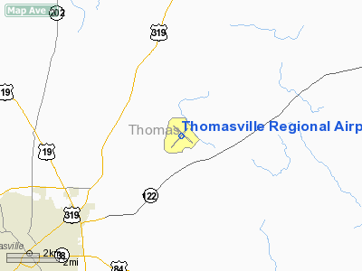
| Location |
Thomas County, near Thomasville, Georgia |
| Elevation AMSL |
264 ft / 80 m |
| Coordinates |
30°54â²06.4515â³N 083°52â²52.0625â³W / 30.901792083°N 83.881128472°W / 30.901792083; -83.881128472Coordinates: 30°54â²06.4515â³N 083°52â²52.0625â³W / 30.901792083°N 83.881128472°W / 30.901792083; -83.881128472 |
| Runways |
| Direction |
Length |
Surface |
| ft |
m |
| 4/22 |
5,496 |
1,675 |
Asphalt |
| 14/32 |
5,000 |
1,524 |
Asphalt |
Thomasville Regional Airport (IATA: TVI, ICAO: KTVI) is a public airport located 4 miles northeast of Thomasville, Georgia. The airport serves the general aviation community, with no scheduled commercial airline service. History
During World War II, Thomasville Army Airfield was a United States Army Air Forces Third Air Force training base for reconnaissance and later fighter pilots.
The 59th Reconnaissance Group flew P-39 Aircobras and P-40 Warhawks from the airfield from 30 March 1943-1 May 1944, providing combat training for replacement pilots before their deployment to the overseas combat theaters. Support organizations included the 1333rd Guard Sq and 493rd Sub Depot. In 1944 all these units were replaced by the 339th AAF Base Unit (Combat Crew Training School, Fighter) which flew the P-51 Mustang.
The military use of the airfield ended on 30 September 1945.
The above content comes from Wikipedia and is published under free licenses – click here to read more.
|
 |
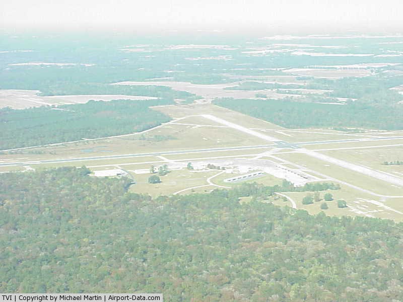
(Click on the photo to enlarge) |
Location
& QuickFacts
|
FAA Information Effective: |
2007-07-05 |
|
Airport
Identifier: |
TVI |
|
Airport
Status: |
Operational |
|
Longitude/Latitude: |
083-52-52.0625W/30-54-06.4515N
-83.881128/30.901792 (Estimated) |
|
Elevation: |
264 ft / 80.47 m (Estimated) |
|
Land: |
1301 acres |
|
From
nearest city: |
6 nautical miles NE of Thomasville, GA |
|
Location: |
Thomas County, GA |
|
Magnetic Variation: |
02W (1985) |
Owner
& Manager
|
Ownership: |
Publicly owned |
|
Owner: |
City Of Thomasville
AND THOMAS COUNTY. |
|
Address: |
Po Box 1540
Thomasville, GA 31799 |
|
Phone number: |
229-227-3262 |
|
Manager: |
Mike Woodham |
|
Address: |
882 Airport Rd
Thomasville, GA 31757 |
|
Phone number: |
912-225-4313 |
Airport
Operations and Facilities
|
Airport Use: |
Open to public |
|
Wind
indicator: |
Yes |
|
Segmented
Circle: |
No |
|
Control
Tower: |
No |
|
Lighting
Schedule: |
DUSK-DAWN
MIRL RY 04/22 PRESET LOW INTST; TO INCR INTST & ACTVT
MALSF - CTAF. ACTVT PAPI RYS 04 & 22 DURG DALGT HRS
- CTAF, AFTER DUSK PAPI RYS 04 & 22 OPER CONT. |
|
Beacon
Color: |
Clear-Green (lighted land airport) |
|
Landing
fee charge: |
No |
|
Sectional
chart: |
Jacksonville |
|
Region: |
ASO - Southern |
|
Boundary
ARTCC: |
ZJX - Jacksonville |
|
Tie-in
FSS: |
MCN - Macon |
|
FSS
on Airport: |
No |
|
FSS
Toll Free: |
1-800-WX-BRIEF |
|
NOTAMs
Facility: |
MCN (NOTAM-d service avaliable) |
|
Federal Agreements: |
NGRY3 |
Airport
Communications
|
CTAF: |
123.075 |
|
Unicom: |
123.075 |
Airport
Services
|
Fuel available: |
100LLA |
|
Airframe Repair: |
MAJOR |
|
Power Plant Repair: |
MAJOR |
|
Bottled
Oxygen: |
NONE |
|
Bulk
Oxygen: |
NONE |
|
Runway Information
Runway 04/22
|
Dimension: |
5496 x 100 ft / 1675.2 x 30.5 m |
|
Surface: |
ASPH, Good Condition |
|
Weight
Limit: |
Single wheel: 30000 lbs. |
|
Edge
Lights: |
Medium |
|
|
Runway 04 |
Runway 22 |
|
Longitude: |
083-53-15.1500W |
083-52-34.7200W |
|
Latitude: |
30-53-42.7900N |
30-54-24.5500N |
|
Elevation: |
238.00
ft |
230.00
ft |
|
Alignment: |
40 |
127 |
|
ILS
Type: |
|
ILS/DME |
|
Traffic
Pattern: |
Left |
Left |
|
Markings: |
Non-precision instrument, Fair Condition |
Non-precision instrument, Fair Condition |
|
Crossing
Height: |
51.00
ft |
59.00
ft |
|
VASI: |
2-light PAPI on left side |
2-light PAPI on left side |
|
Visual
Glide Angle: |
3.00° |
3.00° |
|
Approach
lights: |
|
MALSF |
|
Runway
End Identifier: |
No |
Yes |
|
Obstruction: |
111 ft trees, 1865.0 ft from runway, 400 ft
right of centerline, 15:1 slope to clear |
27 ft trees, 362.0 ft from runway, 490 ft right
of centerline, 6:1 slope to clear |
|
Runway 14/32
|
Dimension: |
5000 x 100 ft / 1524.0 x 30.5 m |
|
Surface: |
ASPH, Good Condition |
|
Weight
Limit: |
Single wheel: 20000 lbs. |
|
Edge
Lights: |
Low |
|
|
Runway 14 |
Runway 32 |
|
Longitude: |
083-53-09.8330W |
083-52-27.9770W |
|
Latitude: |
30-54-26.4280N |
30-53-52.5900N |
|
Elevation: |
264.00
ft |
250.00
ft |
|
Alignment: |
127 |
127 |
|
Traffic
Pattern: |
Left |
Left |
|
Markings: |
Non-precision instrument, Poor Condition
RY MARKINGS BADLY FADED RY 14/32 |
Non-precision instrument, Poor Condition |
|
Obstruction: |
43 ft trees, 1275.0 ft from runway, 25:1 slope
to clear |
48 ft trees, 1256.0 ft from runway, 22:1 slope
to clear |
|
Radio Navigation
Aids
|
ID |
Type |
Name |
Ch |
Freq |
Var |
Dist |
|
GTP |
NDB |
Patten |
|
245.00 |
02W |
4.4 nm |
|
CYR |
NDB |
Caidy |
|
338.00 |
01W |
14.4 nm |
|
CXU |
NDB |
Camilla |
|
369.00 |
02W |
26.3 nm |
|
LYZ |
NDB |
Willis |
|
359.00 |
01W |
33.5 nm |
|
TM |
NDB |
Tifto |
|
409.00 |
03W |
35.7 nm |
|
AB |
NDB |
Putny |
|
227.00 |
02W |
39.0 nm |
|
TL |
NDB |
Wakul |
|
379.00 |
01W |
42.5 nm |
|
IFM |
VOR |
Tift Myers |
|
112.50 |
01W |
37.5 nm |
|
MGR |
VOR/DME |
Moultrie |
025X |
108.80 |
02W |
11.5 nm |
|
OTK |
VOR/DME |
Valdosta |
095X |
114.80 |
02W |
31.9 nm |
|
GEF |
VORTAC |
Greenville |
027X |
109.00 |
01E |
21.7 nm |
|
SZW |
VORTAC |
Seminole |
122X |
117.50 |
02E |
32.9 nm |
|
VAD |
VORTAC |
Moody |
080X |
113.30 |
03W |
35.6 nm |
|
PZD |
VORTAC |
Pecan |
108X |
116.10 |
02W |
50.0 nm |
|
TLH |
VOT |
Tallahassee Muni |
|
111.00 |
|
38.9 nm |
Remarks
- GLIDER
ACTIVITY ON & INVOF ARPT.
- EXISTED
PRIOR TO 1959.
Based
Aircraft
|
Aircraft
based on field: |
64 |
|
Single
Engine Airplanes: |
38 |
|
Multi
Engine Airplanes: |
14 |
|
Jet Engine
Airplanes: |
5 |
|
Gliders: |
5 |
|
Ultralights: |
2 |
Operational Statistics
Time Period: 2005-06-07
- 2006-06-06
|
Aircraft
Operations: |
235/Week |
|
General
Aviation Local: |
57.4% |
|
General
Aviation Itinerant: |
41.0% |
|
Military: |
1.6% |
Thomasville Regional Airport
Address:
Thomas County, GA
Tel:
229-227-3262, 912-225-4313
Images
and information placed above are from
http://www.airport-data.com/airport/TVI/
We
thank them for the data!
| General
Info |
| Country |
United
States |
| State |
GEORGIA
|
| FAA ID |
TVI
|
| Latitude |
30-54-05.587N
|
| Longitude |
083-52-52.808W
|
| Elevation |
264 feet
|
| Near City |
THOMASVILLE
|
We don't guarantee the information is fresh and accurate. The data may
be wrong or outdated.
For more up-to-date information please refer to other sources.
|
|