 |
|
Statesboro - Bulloch County Airport |
Coordinates: 32°28â²58â³N 081°44â²13â³W / 32.48278°N 81.73694°W / 32.48278; -81.73694
| Statesboro-Bulloch County Airport |
 |
| IATA: TBR â ICAO: KTBR â FAA LID: TBR |
| Summary |
| Airport type |
Public |
| Owner |
City of Statesboro & Bulloch County |
| Serves |
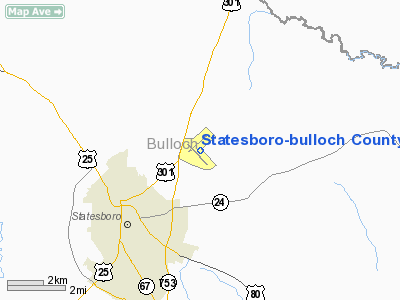
Statesboro, Georgia |
| Location |
Bulloch County, near Statesboro, Georgia |
| Elevation AMSL |
187 ft / 57 m |
| Runways |
| Direction |
Length |
Surface |
| ft |
m |
| 14/32 |
6,000 |
1,829 |
Asphalt |
| 5/23 |
4,383 |
1,336 |
Asphalt |
| Statistics (2007) |
| Aircraft operations |
18,500 |
| Based aircraft |
48 |
| Source: Federal Aviation Administration |
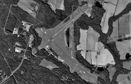
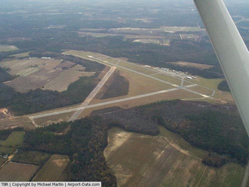
Statesboro-Bulloch County Airport (IATA: TBR, ICAO: KTBR, FAA LID: TBR) is a public airport located three miles (5 km) northeast of the central business district of Statesboro, a city in Bulloch County, Georgia, United States. It is owned by the City of Statesboro and Bulloch County. Currently, there is no commercial service to the airport. Facilities and Aircraft
Statesboro-Bulloch County Airport covers an area of 834 acres (338 ha) which contains two asphalt paved runways: 14/32 measuring 6,000 x 100 ft (1,829 x 30 m) and 5/23 measuring 4,383 x 100 ft (1,336 x 30 m).
Statesboro-Bulloch County Airport is home to the Southeast Georgia Eagle Composite Squadron (GA451) of the Civil Air Patrol.
For the 12-month period ending June 27, 2007, the airport had 18,500 aircraft operations, an average of 51 per day: 54% local general aviation, 43% transient general aviation and 3% military. There are 48 aircraft based at this airport: 94% single-engine and 6% multi-engine.
History
During World War II the airport was used by the United States Army Air Force Third Air Force for antisubmarine patrols and training.
The above content comes from Wikipedia and is published under free licenses – click here to read more.
|
 |
(Click on the photo to enlarge) |
Location
& QuickFacts
|
FAA Information Effective: |
2007-07-05 |
|
Airport
Identifier: |
TBR |
|
Airport
Status: |
Operational |
|
Longitude/Latitude: |
081-44-12.9830W/32-28-57.8580N
-81.736940/32.482738 (Estimated) |
|
Elevation: |
187 ft / 57.00 m (Surveyed) |
|
Land: |
834 acres |
|
From
nearest city: |
3 nautical miles NE of Statesboro, GA |
|
Location: |
Bulloch County, GA |
|
Magnetic Variation: |
05W (2000) |
Owner
& Manager
|
Ownership: |
Publicly owned |
|
Owner: |
Statesboro City & Bulloch County |
|
Address: |
Po Box 347
Statesboro, GA 30458 |
|
Phone number: |
912-764-6245 |
|
Manager: |
Grady Dean |
|
Address: |
601 Airport Blvd
Statesboro, GA 30458 |
|
Phone number: |
912-764-9083 |
Airport
Operations and Facilities
|
Airport Use: |
Open to public |
|
Wind
indicator: |
Yes |
|
Segmented
Circle: |
Yes |
|
Control
Tower: |
No |
|
Lighting
Schedule: |
DUSK-DAWN
HIRL RY 14/32 PRESET ON MED INTST DUSK-2300; TO INCR INTST
& ACTVT MIRL AFTER 2300 - CTAF. ACTVT MALSR RY 32 AND PAPI RYS 14 & 32 - CTAF. |
|
Beacon
Color: |
Clear-Green (lighted land airport) |
|
Landing
fee charge: |
No |
|
Sectional
chart: |
Atlanta |
|
Region: |
ASO - Southern |
|
Boundary
ARTCC: |
ZJX - Jacksonville |
|
Tie-in
FSS: |
MCN - Macon |
|
FSS
on Airport: |
No |
|
FSS
Toll Free: |
1-800-WX-BRIEF |
|
NOTAMs
Facility: |
TBR (NOTAM-d service avaliable) |
|
Federal Agreements: |
NGRY3 |
Airport
Communications
|
CTAF: |
122.800 |
|
Unicom: |
122.800 |
Airport
Services
|
Fuel available: |
100LLA1
24 HR SELF-SERVE FUEL AVBL. |
|
Airframe Repair: |
MAJOR |
|
Power Plant Repair: |
MAJOR |
|
Bottled
Oxygen: |
NONE |
|
Bulk
Oxygen: |
HIGH/LOW |
|
Runway Information
Runway 05/23
|
Dimension: |
4383 x 100 ft / 1335.9 x 30.5 m |
|
Surface: |
ASPH, Good Condition |
|
|
Runway 05 |
Runway 23 |
|
Longitude: |
081-44-34.1499W |
081-43-55.2049W |
|
Latitude: |
32-28-58.5004N |
32-29-26.6238N |
|
Elevation: |
178.00
ft |
187.00
ft |
|
Alignment: |
50 |
127 |
|
Traffic
Pattern: |
Left |
Left |
|
Markings: |
Basic, Fair Condition |
Basic, Fair Condition |
|
Obstruction: |
42 ft trees, 1040.0 ft from runway, 225 ft
left of centerline, 20:1 slope to clear |
55 ft trees, 1740.0 ft from runway, 50 ft right
of centerline, 28:1 slope to clear |
|
Runway 14/32
|
Dimension: |
6000 x 100 ft / 1828.8 x 30.5 m |
|
Surface: |
ASPH, Good Condition |
|
Weight
Limit: |
Single wheel: 27000 lbs.
Dual wheel: 40000 lbs. |
|
Edge
Lights: |
High |
|
|
Runway 14 |
Runway 32 |
|
Longitude: |
081-44-36.4960W |
081-43-46.9960W |
|
Latitude: |
32-29-08.1317N |
32-28-26.1100N |
|
Elevation: |
181.00
ft |
158.00
ft |
|
Alignment: |
127 |
127 |
|
ILS
Type: |
|
ILS |
|
Traffic
Pattern: |
Left |
Left |
|
Markings: |
Precision instrument, Fair Condition |
Precision instrument, Fair Condition |
|
Crossing
Height: |
40.00
ft |
31.00
ft |
|
Displaced
threshold: |
0.00 ft |
300.00
ft |
|
VASI: |
2-light PAPI on left side |
2-light PAPI on left side |
|
Visual
Glide Angle: |
4.00° |
3.00° |
|
Approach
lights: |
|
MALSR |
|
Obstruction: |
91 ft trees, 2202.0 ft from runway, 22:1 slope
to clear |
15 ft trees, 0.0 ft from runway, 400 ft left
of centerline
APCH SLOPE TO DSPLCD THHLD IS 34:1; TREES 650 FT FM DSPLCD
THSHLD 400 FT L. |
|
Radio Navigation
Aids
|
ID |
Type |
Name |
Ch |
Freq |
Var |
Dist |
|
BZ |
NDB |
Bullo |
|
407.00 |
05W |
5.5 nm |
|
JYL |
NDB |
Sylvania |
|
245.00 |
04W |
12.3 nm |
|
CWV |
NDB |
Claxton |
|
395.50 |
04W |
18.7 nm |
|
MHP |
NDB |
Metter |
|
432.00 |
03W |
18.8 nm |
|
LNH |
NDB |
Millen |
|
205.00 |
05W |
27.4 nm |
|
UQN |
NDB |
Onyun |
|
372.00 |
04W |
32.5 nm |
|
RVJ |
NDB |
Prison |
|
424.00 |
03W |
33.1 nm |
|
BXG |
NDB |
Burke County |
|
356.00 |
04W |
36.3 nm |
|
EEX |
NDB |
Emanuel County |
|
309.00 |
04W |
37.9 nm |
|
MOQ |
NDB |
Mc Intosh |
|
263.00 |
04W |
40.9 nm |
|
ALD |
VOR |
Allendale |
|
116.70 |
01W |
39.0 nm |
|
SVN |
VOR/DME |
Hunter |
53X |
111.60 |
02W |
41.5 nm |
|
SAV |
VORTAC |
Savannah |
106Y |
115.95 |
06W |
34.0 nm |
|
SAV |
VOT |
Savannah Travis Fld |
|
111.00 |
|
34.6 nm |
Remarks
- DEER
ON & INVOF ARPT.
- EXISTED
PRIOR TO 1959.
Based
Aircraft
|
Aircraft
based on field: |
40 |
|
Single
Engine Airplanes: |
35 |
|
Multi
Engine Airplanes: |
5 |
Operational Statistics
Time Period: 2004-03-22
- 2005-03-21
|
Aircraft
Operations: |
46/Day |
|
General
Aviation Local: |
48.5% |
|
General
Aviation Itinerant: |
48.5% |
|
Military: |
3.0% |
Statesboro-bulloch County Airport
Address:
Bulloch County, GA
Tel:
912-764-6245, 912-764-9083
Images
and information placed above are from
http://www.airport-data.com/airport/TBR/
We
thank them for the data!
| General
Info |
| Country |
United
States |
| State |
GEORGIA
|
| FAA ID |
TBR
|
| Latitude |
32-28-57.858N
|
| Longitude |
081-44-12.983W
|
| Elevation |
187 feet
|
| Near City |
STATESBORO
|
We don't guarantee the information is fresh and accurate. The data may
be wrong or outdated.
For more up-to-date information please refer to other sources.
|
|


