 |
|
| St. Marys Airport |
| IATA: none – ICAO: none – FAA LID: 4J6 |
| Summary |
| Airport type |
Public |
| Owner |
St. Marys Airport Authority |
| Serves |
St. Marys, Georgia |
| Elevation AMSL |
24 ft / 7 m |
| Coordinates |
30°45′11″N 081°33′32″W / 30.75306°N 81.55889°W / 30.75306; -81.55889 |
| Runways |
| Direction |
Length |
Surface |
| ft |
m |
| 4/22 |
5,000 |
1,524 |
Asphalt |
| 13/31 |
4,000 |
1,219 |
Asphalt |
| Statistics (2007) |
| Aircraft operations |
13,200 |
| Based aircraft |
35 |
| Source: Federal Aviation Administration |
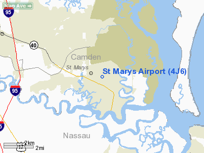
St. Marys Airport (FAA LID: 4J6) is a public-use airport located two nautical miles (4 km) north of the central business district of St. Marys, a city in Camden County, Georgia, United States. It is owned by the St. Marys Airport Authority. Facilities and aircraft
St. Marys Airport covers an area of 286 acres (116 ha) at an elevation of 24 feet (7 m) above mean sea level. It has two asphalt paved runways: 4/22 is 5,000 by 100 feet (1,524 x 30 m); 13/31 is 4,000 by 75 feet (1,219 x 23 m).
For the 12-month period ending August 7, 2007, the airport had 13,200 aircraft operations, an average of 36 per day: 98% general aviation and 2% military. At that time there were 35 aircraft based at this airport: 69% single-engine, 3% multi-engine and 29% ultralight.
Restricted Airspace and Relocation Controversy
The airport and the local government has faced controversy in recent years regarding the possible relocation of the airport in response to national security concerns.
The airport was closed for three months following the September 11, 2001 terrorist attacks, as a result of its position approximately one mile south of Naval Submarine Base Kings Bay. The Federal Aviation Administration created a Temporary Flight Restriction below 5,000 feet and a radius of five miles from the base, effectively eliminating all traffic. Aircraft based at that field were eventually allowed to leave under special permission of air traffic control, but the existing Fixed Base Operator suffered substantial financial difficulties during this time.
The airport was reopened on December 3, 2001, with the creation of a smaller temporary flight restriction located approximately one half mile from the departure end of runway 4. That restriction became permanent on February 16, 2006, with the creation of Prohibited Airspace P-50, an airspace encompassing all airspace below 3,000 feet within a three mile radius of the submarine base's waterfront operations.
Almost immediately after the September 2001 temporary flight restriction was created, the Navy pressed for a permanent closure of the airport for national security reasons. As a result, in April 2004 the city received a grant of $236,538 from the Department of Transportation for an airport relocation study. Nine possible sites were studied by Reynolds, Smith and Hills, a contracted consultant, with a final site approved on February 17, 2005. The new airport location will be south of Woodbine, Georgia, on 500 acres of donated land. The anticipated cost is $29 million, with 90% of the construction costs paid by the Department of Transportation.
The approval for the airport was not without controversy. In February 2007, the St. Marys city council and the St. Marys Airport Authority entered disputes over both airport ownership and whether the airport should even be moved. This eventually led to litigation. On October 2, 2008, the court ruled that the city and not the airport authority had legal control over the property, allowing the move to proceed.
The above content comes from Wikipedia and is published under free licenses – click here to read more.
|
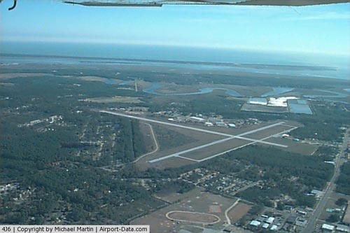 |
(Click on the photo to enlarge) |
Location
& QuickFacts
|
FAA Information Effective: |
2007-07-05 |
|
Airport
Identifier: |
4J6 |
|
Airport
Status: |
Operational |
|
Longitude/Latitude: |
081-33-31.8070W/30-45-10.8370N
-81.558835/30.753010 (Estimated) |
|
Elevation: |
24
ft / 7.32 m (Surveyed) |
|
Land: |
286 acres |
|
From
nearest city: |
2 nautical miles N of St Marys, GA |
|
Location: |
Camden County, GA |
|
Magnetic Variation: |
06W (2005) |
Owner
& Manager
|
Ownership: |
Publicly owned |
|
Owner: |
St Mary's Airport Authority |
|
Address: |
City Hall, 418 Osborne St.
St Marys, GA 31558 |
|
Phone
number: |
912-882-4221 |
|
Manager: |
Dick Russell, Arpt Auth Chair
CHAIRMAN ARPT AUTHORITY. |
|
Address: |
418 Osborne Street
St Marys, GA 31558 |
|
Phone number: |
912-673-6989 |
Airport
Operations and Facilities
|
Airport Use: |
Open to public |
|
Wind
indicator: |
Yes |
|
Segmented
Circle: |
Yes |
|
Control
Tower: |
No |
|
Lighting
Schedule: |
DUSK-DAWN
MIRL RY 04/22 PRESET LOW INTST; TO INCR INTST ACTVT - CTAF. |
|
Beacon
Color: |
Clear-Green (lighted land airport) |
|
Landing
fee charge: |
No |
|
Sectional
chart: |
Jacksonville |
|
Region: |
ASO - Southern |
|
Boundary
ARTCC: |
ZJX - Jacksonville |
|
Tie-in
FSS: |
MCN - Macon |
|
FSS
on Airport: |
No |
|
FSS
Toll Free: |
1-800-WX-BRIEF |
|
NOTAMs
Facility: |
MCN (NOTAM-d service avaliable) |
|
Federal Agreements: |
NGY3 |
Airport
Communications
|
CTAF: |
122.800 |
|
Unicom: |
122.800 |
Airport
Services
|
Fuel available: |
100LLA1+ |
|
Bottled
Oxygen: |
NONE |
|
Bulk
Oxygen: |
NONE |
|
Runway Information
Runway 04/22
|
Dimension: |
5000 x 100 ft / 1524.0 x 30.5 m |
|
Surface: |
ASPH, Good Condition |
|
Weight
Limit: |
Single wheel: 20000 lbs. |
|
Edge
Lights: |
Medium |
|
|
Runway 04 |
Runway 22 |
|
Longitude: |
081-33-43.8000W |
081-33-12.1700W |
|
Latitude: |
30-44-55.1000N |
30-45-36.3700N |
|
Elevation: |
23.00 ft |
21.00 ft |
|
Alignment: |
34 |
127 |
|
Traffic
Pattern: |
Left |
Left |
|
Markings: |
Non-precision instrument, Fair Condition |
Non-precision instrument, Fair Condition |
|
Displaced
threshold: |
290.00
ft |
240.00
ft |
|
Obstruction: |
69 ft trees, 821.0 ft from runway, 300 ft right
of centerline, 9:1 slope to clear
RWY 04 APCH RATIO 0:1 TO DSPLCD THLD; +34 FT TREES 200 FT
FM DSPLCD THLD 350 FT L. |
30 ft trees, 200.0 ft from runway, 250 ft left
of centerline
RWY 22 APCH RATIO 9:1 TO DSPLCD THLD; +42 FT TREES 578 FT
FM DSPLCD THLD AND 300 RIGHT.
RWY 22 +15 FT TREES & BRUSH 180FT OUT FROM RWY END 250
FT L. |
|
Runway 13/31
|
Dimension: |
4000 x 75 ft / 1219.2 x 22.9 m |
|
Surface: |
ASPH, Good Condition |
|
|
Runway 13 |
Runway 31 |
|
Longitude: |
081-33-55.0000W |
081-33-18.1700W |
|
Latitude: |
30-45-16.5000N |
30-44-52.9300N |
|
Elevation: |
24.00
ft |
21.00 ft |
|
Alignment: |
127 |
127 |
|
Traffic
Pattern: |
Left |
Left |
|
Markings: |
Basic, Good Condition |
Basic, Good Condition |
|
Obstruction: |
80 ft trees, 680.0 ft from runway, 250 ft left
of centerline, 6:1 slope to clear |
80 ft trees, 680.0 ft from runway, 275 ft right
of centerline, 6:1 slope to clear |
|
Radio Navigation
Aids
|
ID |
Type |
Name |
Ch |
Freq |
Var |
Dist |
|
EYA |
NDB |
Eastport |
|
357.00 |
03W |
20.0 nm |
|
JA |
NDB |
Dinns |
|
344.00 |
03W |
21.4 nm |
|
JUK |
NDB |
Mc Kinnon |
|
353.00 |
05W |
25.6 nm |
|
HEG |
NDB |
Herlong |
|
332.00 |
02W |
31.4 nm |
|
NRB |
TACAN |
Mayport |
051X |
|
03W |
23.0 nm |
|
NIP |
TACAN |
Jacksonville |
19X |
|
04W |
31.7 nm |
|
NZC |
TACAN |
Cecil/dcmsnd |
088X |
|
04W |
35.9 nm |
|
VQQ |
VOR |
Cecil |
|
117.90 |
03W |
36.7 nm |
|
SGJ |
VOR/DME |
St Augustine |
031X |
109.40 |
06W |
49.3 nm |
|
SSI |
VORTAC |
Brunswick |
035X |
109.80 |
04W |
18.8 nm |
|
CRG |
VORTAC |
Craig |
092X |
114.50 |
03W |
25.0 nm |
|
JAX |
VOT |
Jacksonville Intl |
|
111.00 |
|
17.0 nm |
|
BQK |
VOT |
Brunswick |
|
111.00 |
|
31.7 nm |
Remarks
- (A40-02)
LIGHTING DOES NOT INDICATE DSPLCD THLD.
- RECOMMEND
TWO-WAY RADIO COMMUNICATIONS BE UTILIZED WITH THE CONTROLLING AGENCIES,
WHILE FLYING IN THE VICINITY OF ST. MARY'S ARPT DUE TO A FLIGHT RESTRICTION
1/2 TO 2-1/2 MI N, NE OF ARPT (SEE NOTAMS/TFR).
Based
Aircraft
|
Aircraft
based on field: |
31 |
|
Single
Engine Airplanes: |
18 |
|
Multi
Engine Airplanes: |
3 |
|
Ultralights: |
10 |
Operational Statistics
Time Period: 2004-04-26
- 2005-04-25
|
Aircraft
Operations: |
255/Week |
|
General
Aviation Local: |
37.7% |
|
General
Aviation Itinerant: |
60.4% |
|
Military: |
1.9% |
St Marys Airport
Address:
Camden County, GA
Tel:
912-882-4221,
912-673-6989
Images
and information placed above are from
http://www.airport-data.com/airport/4J6/
We
thank them for the data!
| General
Info |
| Country |
United
States |
| State |
GEORGIA
|
| FAA ID |
4J6
|
| Latitude |
30-45-16.849N
|
| Longitude |
081-33-26.349W
|
| Elevation |
24 feet
|
| Near City |
ST MARYS
|
We don't guarantee the information is fresh and accurate. The data may
be wrong or outdated.
For more up-to-date information please refer to other sources.
|
|


