|
 |
|
||||
|
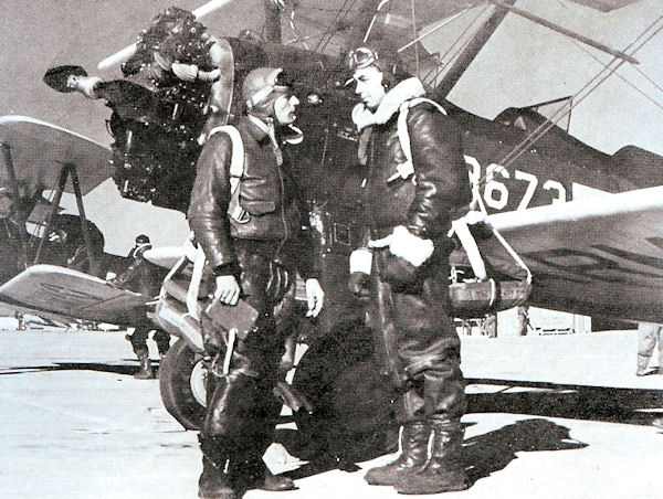
PT-17s on the ramp at Souther Field, 1943
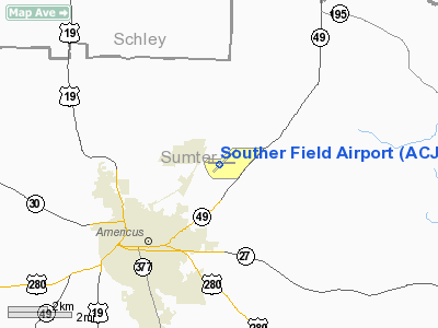
Jimmy Carter Regional Airport (ICAO: KACJ, FAA LID: ACJ) is a public airport located four miles (6 km) northeast of the central business district of Americus, in Sumter County, Georgia, United States. It owned by the City of Americus. Although most U.S. airports use the same three-letter location identifier for the FAA and IATA, Souther Field is assigned ACJ by the FAA but has no designation from the IATA. Facilities and aircraftJimmy Carter Regional Airport covers an area of 378 acres (153 ha) which contains two asphalt paved runways: 5/23 measuring 6,021 x 100 ft (1,835 x 30 m) and 9/27 measuring 3,787 x 75 ft (1,154 x 23 m). For the 12-month period ending June 7, 2006, the airport had 5,600 aircraft operations, an average of 15 per day: 98% general aviation and 2% military. HistoryOriginally named Souther Field, aviation began in 1918, when on 19 January, the War Department leased 407 acres 4.5 miles north of the center of Americus, Georgia from Sumter County for a primary training airfield and an aviation supply depot. The Air Service named the facility Souther Field in honor of Major Henry Souther who served as consulting engineer on many of the World War I aviation projects. Major Souther had been killed earlier in the line of duty at Fort Monroe, Virginia. When completed, the base consisted of warehouses, accommodations for 2,000 officers and men, 15 wooden hangars, and a hospital plus other structures. The first aircraft to land on the field were Standard J-1s powered by Hall Scott motors from Maxwell Field, Alabama. However, Curtiss Jennys, manufactured in Canada, became the first aircraft assigned to the field. Shortly thereafter, 71 more Jennys from the Curtiss factory in Buffalo, New York also arrived. The first 25 cadets reported on 29 May 1918. An additional class of 25 cadets arrived every week until the signing of the armistice. The high-water mark saw 125 officers, 1,400 men, and 147 aircraft at the field. Souther logged more flying hours than any other Army airfield during the war. After the end of the conflict, the War Department deactivated the field and sold its surplus airplanes to the public. One of the surplus aircraft buyers was none other than Charles Lindbergh. In May 1923, Lindbergh paid $500 for a Jenny with a brand-new OX-5 engine, a new paint job, and an extra 20 gal. gasoline tank. He had over 100 Jenny airframes to choose from. Lindbergh aborted his first takeoff attempt on a windy day with his completed Jenny. Lindbergh spent a week practicing at Souther before he finally departed for the barnstorming circuit. In 1928, Sumter County purchased the property. William J. Graham of Pittsburgh, Pennsylvania founded the Graham Aviation Company in April 1938. By the end of 1940, Graham Aviation managed eight airports in western Pennsylvania and operated several pilot schools as well as one flight instructor school. The Army Air Corps asked Graham if he would consider establishing a Contract Pilot School. A pilot, who had trained at Souther during World War I, suggested the former airfield to Graham for his school. Graham and his staff came to Americus and inspected the site. Finding it satisfactory, he leased the property from Sumter County. Construction of the new contract training field began in December 1940 initially consisting of one barracks, a mess hall, a workshop hangar, and a 138 x 204-ft. steel hangar. The necessity of removing the concrete foundations of the World War I buildings slowed construction. The Instructor training program began on 1 February 1941 with five St. Louis Steel Car Company PT-15s. The PT-15 is virtually indistinguishable from the PT-17 Stearman except by the trained eye. The Air Corps bought a total of 14 for evaluation purposes. On 15 March the school received its first 10 PT-17 Stearmans. Officially the 56th Army Air Forces Flying Training Detachment, the school's contract called for training classes of 50 students. The first class began ground school on March 22, 1941. Meanwhile, the Army Air Corps modified Graham's contract for the training of British Royal Air Force cadets. The first class of RAF students arrived from Canada on a train in early June. Local citizens warmly greeted the Brits as they bused through Americus to the school. With the United States entry into the war, the Defense Plant Corporation bought Graham's investment in Souther. An enlargement of the school facilities also got underway for the planned increase in training. Ultimately, the school occupied 644 acres with three hangars. The cantonment area contained two two-story barracks, a recreational ball, an exchange, administration building, Link trainer building, ground school building, mess hall, cold storage plant and a hospital. The school had two auxiliary fields. The British cadets departed Souther in the fall of 1942 with the training of American cadets resuming on September 13, 1942. By the end of 1942, the number of PT-17s present had increased to 107. From January 1, 1943 to January 31, 1944, 2,073 students trained at Souther. The school reached its peak in the winter of 1943/44 with 600 cadets on board and over 450 civil employees that included over 100 flight instructors. Aircraft present reached its zenith with 122 PT-17s, four Fairchild PT-19s, and one BT-13 Valiant, used by the instructors and staff. When the last class graduated in October 1944, the school closed. In 1944 Souther Army Airfield became a site for German prisoners of war, who worked on the farms in the area. The army deactivated Souther Field at the end of World War II and deeded the land to Americus. In 1948 a portion of Souther Field was chartered for the South Georgia Trade and Vocational School (later South Georgia Technical College). Two of the three World War II hangars built by Graham Aviation are still standing, one on the college's campus. The warehouse that had served the field since 1918 is privately owned and stands at the western edge of the campus. Souther Field's World War IIâera concrete apron (in which are embedded iron tie-downs that secured the Stearman biplane trainers) today is used for campus parking. Opposite the college campus and separated by a stand of trees, today's modernized Souther Field is a public-use airport. In 1978 Griffin Bell, an Americus native, presented a memorial plaque to Souther Field Airport to commemorate Charles Lindbergh's 1927 solo flight across the Atlantic Ocean. In 1992 a seven-foot bronze statue of Lindbergh, made by University of Georgia art professor and sculptor William J. Thompson, was dedicated. The statue, commissioned by the Sumter County Historic Preservation Society, stands at Souther Field as part of the airport's Lindbergh Monument. Americus celebrated "Lindbergh Days" in 1985 with a public festival and the installation of a state historical marker. Lindbergh's original JN-4 Jenny biplane, purchased and built at Souther Field, is on display at the Cradle of Aviation Museum in Nassau County, New York. On October 11, 2009, the Americus and Sumter County Airport Authority approved Souther Field's renaming as Jimmy Carter Regional Airport. The new name was initially proposed jointly by the Sumter County Board of Commissioners and the Americus City Council. The above content comes from Wikipedia and is published under free licenses – click here to read more.
Runway InformationRunway 05/23
Runway 09/27
Radio Navigation Aids
Remarks
Based Aircraft
Operational StatisticsTime Period: 2005-06-08 - 2006-06-07
Souther Field Airport Address: Sumter County, GA Tel: 229-924-3090, 229-924-2944 Images
and information placed above are from We thank them for the data!
We don't guarantee the information is fresh and accurate. The data may
be wrong or outdated.
|
||||||||||||||||||||||||||||||||||||||||||||||||||||||||||||||||||||||||||||||||||||||||||||||||||||||||||||||||||||||||||||||||||||||||||||||||||||||||||||||||||||||||||||||||||||||||||||||||||||||||||||||||||||||||||||||||||||||||||||||||||||||||||||||||||||||||||||||||||||||||||||||||||||||||||||||||||||||||||||||||||||||||||||||||||||||||||||||||||||||||||||||||||||||||||||||

 |
|
|