|
 |
|
||||
|
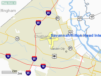
"Savannah/Hilton Head International Airport' (IATA: SAV, ICAO: KSAV, FAA LID: SAV), formerly Savannah International Airport, Travis Field and Chatham Field, is a joint civil-military airport located 7 miles (11 km) northwest of Savannah, Georgia just off Interstate 95, between Savannah and the city of Pooler, Georgia. It is the chief commercial airport for the three-county Savannah metropolitan area, although nearly 40 percent of the airport's total passenger traffic is bound for Hilton Head Island, South Carolina, located approximately 38.5 miles (approx. 42 minutes) away by car. Despite the airport's name, there are currently no scheduled commercial international flights outside the United States from Savannah/Hilton Head. However, U.S. Customs facilities are on the field and the airport is part of a Foreign Trade Zone. As of 2003, Savannah/Hilton Head had 96,816 annual operations (takeoffs and landings) and 887,095 passenger enplanements, making it second only to Hartsfield-Jackson Atlanta International Airport as Georgia's busiest commercial airport. A terminal expansion project was completed in July 2007, adding five departure gates (for a total of fifteen). A $35 million parking garage was completed in October of the same year, which added 1,700 parking spaces and uses an electronic program to alert drivers to the number of available spaces on each garage level. Savannah/Hilton Head is served by Delta (along with Delta Connection carriers ASA and Comair), Continental Express, United Express, US Airways, and American Eagle. An information counter provides local information regarding not only tourist attractions in Savannah and Hilton Head but most other coastal areas of Georgia and southern South Carolina. The airport serves as world headquarters for Gulfstream Aerospace. The Georgia Air National Guard's 165th Airlift Wing is also based at Savannah/Hilton Head International. FacilitiesSavannah/Hilton Head International Airport covers 3,650 acres (14.8 km) and has two runways:
Airlines and destinations
HistoryOriginsSavannah/Hilton Head International Airport was originally named Chatham Field and developed as a Works Progress Administration project at Cherokee Hill, one of the highest elevations in Chatham County, Georgia. In 1939 Congress had instituted a program to improve the nation's airport infrastructure in the interest of National Defense. If local governments provided the land, the Federal Government would fund construction of the airport. The City then approached the Civil Aeronautics Administration (CAA) about the possibility of building a an airport at Cherokee Hill. The CAA accepted this proposal informing the City that as much as $400,000 would be allocated for construction of three 4,000-ft. runways. The City purchased 600 acres at the CAA approved site seven miles northwest of town center for $20,000. By the time the project got underway in 1941, the United States was on an unalterable road to war and the Army Air Corps as well as the Navy took an interest in the strategically located coastal airport. The United States Navy, looking for a blimp base in the area, attempted to gain control of the airfield. The Air Corps, on the other hand, wanted the airfield for an auxiliary of Hunter Field, located 8 miles south. The Interdepartmental Air Traffic Control Board, consisting of members of the Army, Navy and CAA to resolve conflicts such as this between the services, sided with the Air Corps. The Navy eventually built a blimp base at Brunswick, Georgia, 75 miles to the south. With the Air Corps established already in the Savannah area at Hunter Field, work on Chatam proceeded at a slow pace. The construction project involved improving runways and airplane hangars, with three concrete runways, several taxiways and a large parking apron and a control tower being built. Several large hangars were also constructed. Buildings were ultimately utilitarian and quickly assembled. Most base buildings, not meant for long-term use, were constructed of temporary or semi-permanent materials. Although some hangars had steel frames and the occasional brick or tile brick building could be seen, most support buildings sat on concrete foundations but were of frame construction clad in little more than plywood and tarpaper. Chatam Army Airfield, named for its Georgia county location, finally activated on 19 September 1943, over two years since construction began. World War II
Initially a sub-base of Hunter Field, the Air Force intended Chatham AAF for use by Third Air Force, III Reconnaissance Command and the Army Air Forces Antisubmarine Command. In June 1943, the 100th Bombardment Squadron (Medium), was assigned to the airfield flying B-25 Mitchell bombers on antisubmarine patrols. However, in August, the antisubmarine patrol mission was transferred to the United States Navy. Two days after the base's activation, First Air Force took over command and made Chatham a sub-base of Jacksonville AAF. First Air Force used Chatham for B-24 operational training. Although Chatham had an adequate airfield, the cantonment area was deemed lacking with accommodations for only a reduced station complement and one tactical squadron. This presented a major problem since insufficient facilities existed to accommodate a B-24 group scheduled to arrive in the latter part of October. Hard work by base personnel provided necessary facilities when the 460th Bombardment Group, consisting of the 760th , 761st, 762nd, and the 763rd Bombardment Squadrons, arrived on 29 October 1943. After the 460th BG deployed to Fifteenth Air Force in Italy during January 1944. First Air Force changed Chatham's mission to replacement training. The 302d Bombardment Group (355th, 356th, 357th and 420th) flying B-24s as the Operational Training Units, training replacement B-24 aircrews. The 460th was replaced by squadrons of the 302d Bombardment Group (355th, 356th, 357th and 420th) flying B-24s as Operational Training Units, training replacement B-24 aircrews. On 1 May 1945, Chatham AAF was transferred from the First to the Third Air Force. Among the eight generals present for the ceremony was Major General Frank Hunter, commander of the First Air Force, a Savannah native, and the namesake of nearby Hunter Field. Among his acts that day, Hunter decorated eleven of Chatham's men. Chatham's new mission under Third Air Force was a training base for the B-29 Superfortress. By July, 29 B-29s were on hand. However, with the end of the war in 1945, Chatam AAF was no longer needed and it was placed on inactive status on 10 January 1946, with the 324 Army Air Force Base Unit (Standby) assuming caretaker duties over the facility. Cold WarThe reconstituted Georgia Air National Guard stationed its 158th Fighter Squadron at Chatham Field on 13 October 1946, flying its P-47 Thunderbolts until 1949 when it moved to Hunter AFB to accommodate the active-duty Air Force. On 17 July 1947, the United States Air Force reactivated the Airfield. Chatam was assigned to Strategic Air Command, with the 380th Bombardment Group being assigned to jurisdiction of the base, and work was begun to modernize the airfield from its World War II wartime configuration into a permanent Air Force Base with modern facilities. Although Chatham had an adequate airfield for B-29 operations, the cantonment area was in poor condition. Constructed to last for five years, the buildings had reached the end of their life expectancy. In addition, the buildings' shortcomings also included outside latrines and potbellied stoves for heating. In January 1948, the base was renamed Chatam Air Force Base. On 1 November 1948 Boeing B-50 Superfortress aircraft were assigned to the base from the 307th Bombardment Group, with a mission being transition training of B-29 bomber crews to the new B-50. On 1 March 1949, Chatam was reassigned to Eighth Air Force and the 2d Bombardment Group was reassigned from Davis-Monthan AFB, Arizona to Chatam, with B-50s. The inadequacies of the support facilities at Chatham caused the Air Force to make the decision to leave Chatham and move to Hunter or leave Savannah. The facilities at Hunter AFB were built in the 1930s to permanent specifications and made Hunter much more desirable than Chatham. The City of Savannah interceded with the Air Force and offered to trade the larger Hunter Field, then a municipal airport, for the smaller Chatham AFB to keep SAC and the USAF in Savannah. This arrangement was agreed to and on 29 September 1950, the 2d Bomb Group moved to Hunter AFB and Chatam was turned over to the City of Savannah. Post-military useOnce back under civil control, the airport was renamed Travis Field, in honor of Savannah natives Brigadier General. Robert F. Travis, killed in the crash of a B-29 near Fairfield-Suisun AFB, California, and his brother, Colonel William Travis. To accommodate the airlines, Travis Field received a new control tower and an airline terminal in the former base theater. In 1953, when the Air National Guard 158th Fighter Squadron returned from activation during the Korean War, it based at Travis Field. This required the extension of Travis's east/west runway to 8,000 ft. for the Guard's F-84 Thunderjets. In 1958, work began on a new airline terminal. In 1962, an additional extension brought the east/west runway's length to 9,000 ft. Jet service by Delta Air Lines began in 1965 using the Douglas DC-9. Grumman Aircraft opened a $7.5 million Gulfstream manufacturing plant at Travis in 1967. In 1991, Delta Air Lines celebrated 50 years of service to Savannah. A new $21 million terminal building was built on the northwest corner of the airport in 1994. A six-gate terminal built in 1960 was replaced in 1994 by the current facility. Although the airport has no direct international flights, it was renamed Savannah International in 1983, then Savannah/Hilton Head International in 2003. Some 3,680 feet (1,120 m) from the west end of Runway 10 (the main east-west runway) are two concrete grave markers. A runway extension project placed the runway through a small family plot and the graves of the airport property's two original owners. Because the family did not want to remove and relocate the graves, the markers were placed in the asphalt runway. Runway 10 is thought to be the only airport runway in the United States with marked gravestones in it. Federal law generally prohibits the moving of a grave without the permission of the next of kin. In this case, two graves of the Dotson Family, the earliest grave dating backed to 1857, were encountered during the construction of the runway. Since the next of kin could not be located, the graves were left undisturbed. Two additional graves are located off the runway surface. Savannah Air National Guard BaseSavannah ANGB at Savannah/Hilton Head International Airport is home to the 165th Airlift Wing (165 AW), an Air Mobility Command (AMC)-gained unit of the Georgia Air National Guard, currently flying the C-130H Hercules tactical airlift aircraft. The wing consists of over 900 full-time Active Guard and Reserve (AGR), Air Reserve Technician (ART) and part-time "traditional" air national guardsmen, available for domestic operations as an Air National Guard unit or world-wide deployment in support of the U.S. Air Force and unified combatant commanders. Savannah ANGB also hosts the Combat Readiness Training Center (CRTC). Located at Savannah/Hilton Head International Airport/Savannah ANGB, the CRTC is one of four such training facilities in the nation. The CRTC provides airspace and ranges, aircraft parking, aircraft ground equipment (AGE), maintenance areas, training facilities, dormitories and other support functions for regular U.S. Air Force, Air Force Reserve Command, Air National Guard, U.S. Navy, Navy Reserve, U.S. Marine Corps and Marine Corps Reserve tactical jet aviation units. The above content comes from Wikipedia and is published under free licenses – click here to read more.
Runway InformationRunway 09/27
Runway 18/36
Radio Navigation Aids
Remarks
Based Aircraft
Major Carriers Serving This Airport
Most Popular Destinations
Most Popular Aircraft
Operational StatisticsTime Period: 2005-07-01 - 2006-06-30
Savannah/hilton Head International Airport Address: Chatham County, GA Tel: 912-964-0514 Images
and information placed above are from We thank them for the data!
We don't guarantee the information is fresh and accurate. The data may
be wrong or outdated.
|
|||||||||||||||||||||||||||||||||||||||||||||||||||||||||||||||||||||||||||||||||||||||||||||||||||||||||||||||||||||||||||||||||||||||||||||||||||||||||||||||||||||||||||||||||||||||||||||||||||||||||||||||||||||||||||||||||||||||||||||||||||||||||||||||||||||||||||||||||||||||||||||||||||||||||||||||||||||||||||||||||||||||||||||||||||||||||||||||||||||||||||||||||||||||||||||||||||||||||||||||||||||||||||||||||||||||||||||||||||||||||||||||||||||||||||||||||||||||||||||||||||||||||||||||||||||||||||||

 |
|
|