 |
|
Richard B Russell Airport |
| Richard B. Russell Airport |
 |
| USGS aerial image - 8 February 1999 |
| IATA: RMG â ICAO: KRMG â FAA LID: RMG |
| Summary |
| Airport type |
Public |
| Owner |
Floyd County |
| Serves |
Rome, Georgia |
| Elevation AMSL |
644 ft / 196 m |
| Coordinates |
34°21â²03â³N 085°09â²31â³W / 34.35083°N 85.15861°W / 34.35083; -85.15861 |
| Website |
www.floydcountyga.org/... |
| Runways |
| Direction |
Length |
Surface |
| ft |
m |
| 1/19 |
6,006 |
1,831 |
Asphalt |
| 7/25 |
4,497 |
1,371 |
Asphalt |
| Statistics (2007) |
| Aircraft operations |
36,703 |
| Based aircraft |
775 |
| Source: Federal Aviation Administration |
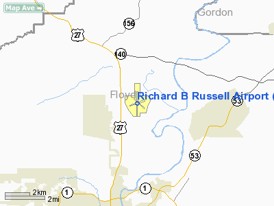
Richard B. Russell Airport (IATA: RMG, ICAO: KRMG, FAA LID: RMG) is a county-owned public-use airport in Floyd County, Georgia, United States. The airport is located six nautical miles (11 km) north of the central business district of Rome, Georgia. It is also known as Richard B. Russell Regional Airport and J.H. Towers Field.
This airport is included in the FAA's National Plan of Integrated Airport Systems (2009-2013), which categorizes it as a general aviation facility.
The Rome Composite Squadron of the Civil Air Patrol is located at the airport. Stationed at the squadron are a Maule MT-7-235 tow plane and three Blanik gliders.
On the second Saturday of each month, the Experimental Aircraft Association hosts a fly-in breakfast at the EAA campgrounds located off the Old Dalton Road. History
Floyd County purchased 670 acres (271 ha) of land for the airport in 1942. The county turned the land over to the U.S. Navy which built three asphalt runways for a Naval Auxiliary Air Base. It was deeded back to the county in 1945, after the Navy discontinued its use of the site. The airport was then named for Richard B. Russell, Jr., who represented Georgia in the U.S. Senate from 1933 until his death in 1971. In 2004, the terminal building was named for Admiral John H. Towers, a pioneer of naval aviation.
Facilities and aircraft
The airport covers an area of 985 acres (399 ha) at an elevation of 644 feet (196 m) above mean sea level. It has two asphalt paved runways: 1/19 measures 6,006 by 143 feet (1,831 x 44 m) and 7/25 is 4,497 by 100 feet (1,371 x 30 m). A former third runway which was designated 14/32 is closed.
For the 12-month period ending August 31, 2007, the airport had 36,703 aircraft operations, an average of 100 per day: 98% general aviation and 2% military. At that time there were 775 aircraft based at this airport: 88% military, 9% single-engine, 1% multi-engine, 1% ultralight, <1% glider, <1% jet and <1% helicopter.
The above content comes from Wikipedia and is published under free licenses – click here to read more.
|
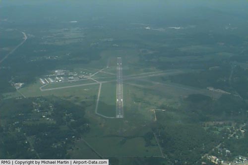 |
(Click on the photo to enlarge) |
|
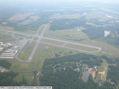 |
(Click on the photo to enlarge) |
Location
& QuickFacts
|
FAA Information Effective: |
2007-07-05 |
|
Airport
Identifier: |
RMG |
|
Airport
Status: |
Operational |
|
Longitude/Latitude: |
085-09-28.8500W/34-21-02.1640N
-85.158014/34.350601 (Estimated) |
|
Elevation: |
644 ft / 196.29 m (Surveyed) |
|
Land: |
985 acres |
|
From
nearest city: |
6 nautical miles N of Rome, GA |
|
Location: |
Floyd County, GA |
|
Magnetic Variation: |
02W (1985) |
Owner
& Manager
|
Ownership: |
Publicly owned |
|
Owner: |
Floyd County |
|
Address: |
County Courthouse
Rome, GA 30161 |
|
Phone number: |
706-295-7835 |
|
Manager: |
Mike Mathews |
|
Address: |
304 Russell Fld
Rome, GA 30161 |
|
Phone number: |
706-295-7835 |
Airport
Operations and Facilities
|
Airport Use: |
Open to public |
|
Wind
indicator: |
Yes |
|
Segmented
Circle: |
Yes |
|
Control
Tower: |
No |
|
Lighting
Schedule: |
DUSK-DAWN
ACTVT HIRL RY 01/19, PAPI RY 01 PVASI RY 19 & MALSR
RY 01 - CTAF. |
|
Beacon
Color: |
Clear-Green (lighted land airport) |
|
Landing
fee charge: |
No |
|
Sectional
chart: |
Atlanta |
|
Region: |
ASO - Southern |
|
Boundary
ARTCC: |
ZTL - Atlanta |
|
Tie-in
FSS: |
MCN - Macon |
|
FSS
on Airport: |
No |
|
FSS
Toll Free: |
1-800-WX-BRIEF |
|
NOTAMs
Facility: |
RMG (NOTAM-d service avaliable) |
|
Certification
type/date: |
IV A U 12/197
CLSD TO UNSKED ACR OPNS WITH MORE THAN 30 PSGR SEATS EXCP
24 HRS PPR CALL AMGR 706-295-7835. |
|
Federal Agreements: |
NGY3 |
Airport
Communications
|
CTAF: |
123.000 |
|
Unicom: |
123.000 |
Airport
Services
|
Fuel available: |
100 A |
|
Airframe Repair: |
MAJOR |
|
Power Plant Repair: |
MAJOR |
|
Bottled
Oxygen: |
NONE |
|
Bulk
Oxygen: |
NONE |
|
Runway Information
Runway 01/19
|
Dimension: |
6000 x 150 ft / 1828.8 x 45.7 m |
|
Surface: |
ASPH, Fair Condition |
|
Surface
Treatment: |
Saw-cut or plastic Grooved |
|
Weight
Limit: |
Single wheel: 52000 lbs.
Dual wheel: 57000 lbs.
Dual
tandem wheel: 114000 lbs. |
|
Edge
Lights: |
High |
|
|
Runway 01 |
Runway 19 |
|
Longitude: |
085-09-34.0330W |
085-09-27.8640W |
|
Latitude: |
34-20-33.9750N |
34-21-33.1020N |
|
Elevation: |
632.00 ft |
624.00 ft |
|
Alignment: |
5 |
127 |
|
ILS
Type: |
ILS/DME |
|
|
Traffic
Pattern: |
Left |
Left |
|
Markings: |
Precision instrument, Poor Condition
RY 01 MARKINGS FADED AND OBSCURED. |
Precision instrument, Poor Condition
RY 19 MARKINGS FADED AND OBSCURED. |
|
Crossing
Height: |
46.00 ft |
39.00 ft |
|
VASI: |
4-light PAPI on left side |
pulsating/steady burning on left side
PVASI OTS INDEFLY. |
|
Visual
Glide Angle: |
3.00° |
3.50° |
|
Approach
lights: |
MALSR |
|
|
Runway
End Identifier: |
|
No |
|
Obstruction: |
17 ft tree, 800.0 ft from runway, 150 ft left
of centerline, 34:1 slope to clear
GROUND ON EXTNDD CNTRLN.
37:1 TO GROUND 8 FT ABV RY ELEV 500 FT OUT. |
55 ft tree, 2300.0 ft from runway, 100 ft left
of centerline, 38:1 slope to clear
TREE 250' LEFT. |
|
Runway 07/25
|
Dimension: |
4497 x 100 ft / 1370.7 x 30.5 m |
|
Surface: |
ASPH, Fair Condition |
|
Weight
Limit: |
Single wheel: 16000 lbs.
Dual wheel: 30000 lbs. |
|
|
Runway 07 |
Runway 25 |
|
Longitude: |
085-09-56.7490W |
085-09-06.3710W |
|
Latitude: |
34-20-54.2160N |
34-21-09.4720N |
|
Elevation: |
644.00 ft |
626.00 ft |
|
Alignment: |
70 |
127 |
|
Traffic
Pattern: |
Left |
Left |
|
Markings: |
Basic, Good Condition |
Basic, Good Condition |
|
Displaced
threshold: |
249.00 ft |
0.00 ft |
|
Obstruction: |
53 ft tree, 999.0 ft from runway, 193 ft right
of centerline, 15:1 slope to clear
TREES FROM EXTNDD CNTRLN TO 190' RIGHT.
APCH RATIO 20:1 AT DSPLCD THLD; +54 FT TREES 1425 FT FM DSPLCD
THLD 100 FT L |
56 ft tree, 2110.0 ft from runway, 225 ft right
of centerline, 20:1 slope to clear
TREE ON EXTNDD CNTRLN. |
|
Radio Navigation
Aids
|
ID |
Type |
Name |
Ch |
Freq |
Var |
Dist |
|
OYD |
NDB |
Floyd |
|
388.00 |
02W |
3.1 nm |
|
OUK |
NDB |
Calhoun |
|
323.00 |
02W |
11.9 nm |
|
EVZ |
NDB |
Cartersville |
|
308.00 |
04W |
18.1 nm |
|
FTP |
NDB |
Fort Payne |
|
426.00 |
01W |
27.5 nm |
|
UWI |
NDB |
Whitfield |
|
400.00 |
03W |
28.4 nm |
|
DJD |
NDB |
Canton |
|
415.00 |
04W |
33.8 nm |
|
JZP |
NDB |
Pickens County |
|
285.00 |
04W |
35.2 nm |
|
FT |
NDB |
Flanc |
|
344.00 |
02W |
43.8 nm |
|
GPQ |
NDB |
Carrollton |
|
278.00 |
02W |
47.2 nm |
|
APT |
NDB |
Jasper |
|
382.00 |
02W |
47.5 nm |
|
CQN |
NDB |
Daisy |
|
341.00 |
02W |
49.0 nm |
|
HDI |
NDB |
Hardwick |
|
369.00 |
01W |
49.9 nm |
|
DOB |
TACAN |
Dobbins |
077X |
|
01W |
41.7 nm |
|
RMG |
VORTAC |
Rome |
101X |
115.40 |
01E |
11.5 nm |
|
GQO |
VORTAC |
Choo Choo |
105X |
115.80 |
01E |
36.7 nm |
Remarks
- ULTRALIGHT
ACTIVITY ON & INVOF ARPT.
- DEER
ON INVOF ARPT.
- MIL
AIR CARGO DROP (C130 ACFT) IN PROGRESS 1830-2030 TUE AND THU AT NE END
OF RY 07/25.
- BARRELS
ON RAMP AREA SW OF TERMINAL BLDG.
Based
Aircraft
|
Aircraft
based on field: |
139 |
|
Single
Engine Airplanes: |
117 |
|
Multi
Engine Airplanes: |
10 |
|
Jet Engine
Airplanes: |
2 |
|
Gliders: |
3 |
|
Ultralights: |
7 |
Operational Statistics
Time Period: 2004-10-01 - 2005-09-30
|
Aircraft
Operations: |
93/Day |
|
General
Aviation Local: |
46.8% |
|
General
Aviation Itinerant: |
51.0% |
|
Military: |
2.2% |
Richard B Russell Airport
Address:
Floyd County, GA
Tel:
706-295-7835
Images
and information placed above are from
http://www.airport-data.com/airport/RMG/
We
thank them for the data!
| General
Info |
| Country |
United
States |
| State |
GEORGIA
|
| FAA ID |
RMG
|
| Latitude |
34-21-02.164N
|
| Longitude |
085-09-28.850W
|
| Elevation |
644 feet
|
| Near City |
ROME
|
We don't guarantee the information is fresh and accurate. The data may
be wrong or outdated.
For more up-to-date information please refer to other sources.
|
|


