 |
|
|
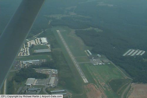 |
(Click on the photo to enlarge) |
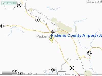
Location
& QuickFacts
|
FAA Information Effective: |
2007-07-05 |
|
Airport
Identifier: |
JZP |
|
Airport
Status: |
Operational |
|
Longitude/Latitude: |
084-27-26.0000W/34-27-12.5000N
-84.457222/34.453472 (Estimated) |
|
Elevation: |
1535 ft / 467.87 m (Surveyed) |
|
Land: |
114 acres |
|
From
nearest city: |
2 nautical miles SW of Jasper, GA |
|
Location: |
Pickens County, GA |
|
Magnetic Variation: |
04W (2000) |
Owner
& Manager
|
Ownership: |
Publicly owned |
|
Owner: |
Pickens County |
|
Address: |
52 North Main Street, Suite 201
Jasper, GA 30143 |
|
Phone number: |
706-253-8817 |
|
Manager: |
Howard Ray |
|
Address: |
193 Airport Road
Jasper, GA 30143 |
|
Phone number: |
706-253-8830 |
Airport
Operations and Facilities
|
Airport Use: |
Open to public |
|
Wind
indicator: |
Yes |
|
Segmented
Circle: |
Yes |
|
Control
Tower: |
No |
|
Lighting
Schedule: |
DUSK-DAWN
MIRL RY 16/34 PRESET ON LOW INTST DUSK-0000; TO INCR INTST
& ACTVT AFTER 0000 - CTAF. |
|
Beacon
Color: |
Clear-Green (lighted land airport) |
|
Landing
fee charge: |
No |
|
Sectional
chart: |
Atlanta |
|
Region: |
ASO - Southern |
|
Boundary
ARTCC: |
ZTL - Atlanta |
|
Tie-in
FSS: |
MCN - Macon |
|
FSS
on Airport: |
No |
|
FSS
Toll Free: |
1-800-WX-BRIEF |
|
NOTAMs
Facility: |
MCN (NOTAM-d service avaliable) |
|
Federal Agreements: |
NGY |
Airport
Communications
|
CTAF: |
122.800 |
|
Unicom: |
122.800 |
Airport
Services
|
Fuel available: |
100LL |
|
Airframe Repair: |
NONE |
|
Power Plant Repair: |
NONE |
|
Bottled
Oxygen: |
NONE |
|
Bulk
Oxygen: |
NONE |
|
Runway Information
Runway 16/34
|
Dimension: |
5000 x 100 ft / 1524.0 x 30.5 m |
|
Surface: |
ASPH, Good Condition |
|
Weight
Limit: |
Single wheel: 14000 lbs. |
|
Edge
Lights: |
Medium |
|
|
Runway 16 |
Runway 34 |
|
Longitude: |
084-27-36.8074W |
084-27-15.0831W |
|
Latitude: |
34-27-35.5721N |
34-26-49.5053N |
|
Elevation: |
1500.00
ft |
1535.00
ft |
|
Alignment: |
127 |
127 |
|
Traffic
Pattern: |
Left |
Left |
|
Markings: |
Non-precision instrument, Fair Condition |
Non-precision instrument, Fair Condition |
|
Crossing
Height: |
25.00
ft |
29.00
ft |
|
VASI: |
2-light PAPI on right side |
2-light PAPI on left side |
|
Visual
Glide Angle: |
3.00° |
3.00° |
|
Obstruction: |
49 ft trees, 1180.0 ft from runway, 350 ft
left of centerline, 20:1 slope to clear |
, 50:1 slope to clear |
|
Radio Navigation
Aids
|
ID |
Type |
Name |
Ch |
Freq |
Var |
Dist |
|
JZP |
NDB |
Pickens County |
|
285.00 |
04W |
0.2 nm |
|
DJD |
NDB |
Canton |
|
415.00 |
04W |
12.2 nm |
|
OUK |
NDB |
Calhoun |
|
323.00 |
02W |
23.5 nm |
|
EVZ |
NDB |
Cartersville |
|
308.00 |
04W |
24.5 nm |
|
FKV |
NDB |
Flowery Branch |
|
365.00 |
03W |
31.2 nm |
|
UWI |
NDB |
Whitfield |
|
400.00 |
03W |
31.5 nm |
|
OYD |
NDB |
Floyd |
|
388.00 |
02W |
36.3 nm |
|
FT |
NDB |
Flanc |
|
344.00 |
02W |
42.5 nm |
|
AJR |
NDB |
Habersham |
|
347.00 |
03W |
45.1 nm |
|
TTQ |
NDB |
Tomotla |
|
335.00 |
01W |
46.9 nm |
|
HDI |
NDB |
Hardwick |
|
369.00 |
01W |
47.6 nm |
|
BR |
NDB |
Redan |
|
266.00 |
02W |
49.1 nm |
|
DOB |
TACAN |
Dobbins |
077X |
|
01W |
32.5 nm |
|
PDK |
VOR/DME |
Peachtree |
113X |
116.60 |
02W |
35.6 nm |
|
RMG |
VORTAC |
Rome |
101X |
115.40 |
01E |
37.2 nm |
|
HRS |
VORTAC |
Harris |
035X |
109.80 |
00E |
39.8 nm |
|
GQO |
VORTAC |
Choo Choo |
105X |
115.80 |
01E |
46.0 nm |
|
ATL |
VORTAC |
Atlanta |
116X |
116.90 |
00W |
49.6 nm |
|
ATL |
VOT |
Atlanta Muni |
|
111.00 |
|
47.8 nm |
Remarks
- EXTENSIVE
STUDENT TRNG ATL340045-ATL355049; 3000-9000 FT; 1200-1730.
- GCO
AVBL ON FREQ 121.725 THRU FLT SVCS.
- VFR
OPERATIONS ONLY.
Based
Aircraft
|
Aircraft
based on field: |
46 |
|
Single
Engine Airplanes: |
42 |
|
Multi
Engine Airplanes: |
2 |
|
Ultralights: |
2 |
Operational Statistics
Time Period: 2004-05-05
- 2005-05-04
|
Aircraft
Operations: |
212/Week |
|
General
Aviation Local: |
54.5% |
|
General
Aviation Itinerant: |
45.5% |
Pickens County Airport
Address:
Pickens County, GA
Tel:
706-253-8817, 706-253-8830
Images
and information placed above are from
http://www.airport-data.com/airport/JZP/
We
thank them for the data!
| General
Info |
| Country |
United
States |
| State |
GEORGIA
|
| FAA ID |
JZP
|
| Latitude |
34-27-12.145N
|
| Longitude |
084-27-26.520W
|
| Elevation |
1535 feet
|
| Near City |
JASPER
|
We don't guarantee the information is fresh and accurate. The data may
be wrong or outdated.
For more up-to-date information please refer to other sources.
|
|


